Gippel
| Gippel | ||
|---|---|---|
|
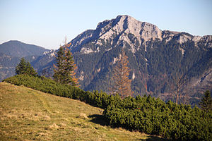
View of the Gippel from the west (Göllerwiese) |
||
| height | 1669 m above sea level A. | |
| location | Lower Austria , Austria | |
| Mountains | Göller-Gippel-Zug , Mürzsteg Alps | |
| Dominance | 6.3 km → Göller | |
| Notch height | 403 m ↓ Waldhüttsattel | |
| Coordinates | 47 ° 47 '55 " N , 15 ° 34' 50" E | |
|
|
||
| rock | Banked Dachstein limestone | |
| Age of the rock | Upper Carnium - Rhaetium | |
The Gippel is a 1669 m above sea level. A. high mountain in the Mürzsteg Alps in southern Lower Austria .
Location and character of the mountain
The very distinctive mountain range of the Gippel , characterized in the upper third by banked Dachstein limestone , is one of the popular tour destinations in the vicinity of Vienna, together with the neighboring Göller ( 1766 m ) to the west . It rises about 6 kilometers south of the market town of St. Aegyd am Neuwalde . The peripheral valleys of the approximately 50 km² mountain range belong orographically to the Traisen , Schwarza and Mürz rivers .
The Gippel is "a mountain with many faces". If you look from Kernhof to its north face, it looks almost like a rugged three-thousand-meter peak. On the ascent to the summit, about 1100 meters of altitude must be overcome, which is quite comparable to many tours in the Central Alps. In clear contrast to the rocky north flank, which stretches as a 300 m high Gippel wall 3–4 km east to the Schwarzauer Gippel ( 1605 m ), the meadow-covered south side has an almost lovely character.
The Gippel offers an impressive panorama of large parts of the Styrian-Lower Austrian Limestone Alps .
The Gippel from the northwest ( Tirolerkogel ), in the far back Rax and Schneeberg
Paths & climbs
Two regional long-distance hiking trails lead over the Gippel, the Traisentaler Rundwanderweg 655 and the Waldmarkweg 622 .
From the north (Sankt Aegyd)
This popular ascent, which takes 2-3 hours, begins at the Zögernitzer homestead (640 m) in the Weißenbachtal , 4 km to St. Aegyd. A forest road soon leads to the driving path , which was expanded in 1930 and which owes its name to its use for driving up and down the mountain pastures. In spring it is usually only accessible from May / June due to residual snow fields. A few serpentines lead under the steep north face to the Gippeltörl , a narrow notch with an alpine gate and a view of the Sonnleitstein group and the Schneealpe . A few minutes further south-west are the halter huts of the Gippelalm ( 1500 m , refreshment stops on weekends). The path now climbs west on the ridge to the Gippel with its summit cross . For the way back, after the descent over the upper part of the ascent path, branching off from the Treibsteig, a round tour to the west to the Reintaler Alm ( Lage ) is recommended . About 350 meters in altitude below the Gippeltörl you follow a forest road to the west to the Alm under the northern slopes of the Gippelmauer. A short distance without a path to the marked path over the Luegerberg . On this north-east down into the Weißenbachtal and via the Knollnhof farm to the starting point.
From the east
A hiking trail leads from Obersberg (Ahornberg) over the Preineckkogel to the Preinecksattel (which can also be reached from St. Aegyd or the Preintal (community of Schwarzau im Gebirge )). A forest road then continues under the north side of the Gippels to the Treibsteig . An alternative is a steep climb from the Preinecksattel to the Schwarzauer Gippel and through narrow Latschengassen of the Gippelmauer to the Gippeltörl.
From the west
The Kammweg from the Waldhüttsattel ( 1266 m ), which is best accessible from Kernhof in the north or from Donaudörfl in the south, approaches the Gippel via the Hofalm and the Gamsmauer . The Roman-Majevski-Steig initially bypasses the Gippel on its south side; the summit can then be reached via the marked path from the east. A direct connection from the ridge path near the Pollwischalm to the summit is the mountain rescue trail , which was renovated in 2008 (places with steel cable protection and step pins; surefootedness and a head for heights required).
Ski tour
In winter, the Gippel is a rarely visited and therefore a quiet destination for ski tours . The best starting point is at the former Triebl inn in the Preintal. The Gippel can be reached via the saddle of the Gscheidl and the Perschkogel .
literature
- Franz Hauleitner: Ötscher. Mariazell - Türnitz - Traisentaler Berge , Bergverlag Rudolf Rother , Munich 2010, 4th edition. ISBN 978-3-7633-4026-2
- Adi Mokrejs: Bergwanderatlas Niederösterreich , Schall-Verlag, Alland 2012, 2nd edition. ISBN 978-3-900533-66-3
Remarks
- ↑ This is the title of the tour description on www.BergNews.com
- ↑ See the route description on www.bergstieg.at.
Web links
- Camels and a mountain with many faces : route description on www.BergNews.com
- Perschkogel - Gippelgraben : Description of ski tours on www.berghaben.at


