Schwarza (Leitha)
The Schwarza is a river in Lower Austria . It is a source river of the Leitha .
geography
course
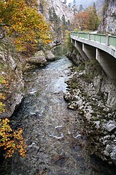
It arises south of the Kalten Kuchl in the Tiefental in the municipality of Rohr im Gebirge through the confluence of the source streams Dürre Schwarza and Grüne Schwarza . After a short walk westwards it swings into its upper main valley, the area . A little way to Schwarzau Markt it flows through the Höllental , between the Rax and Schneeberg massifs .
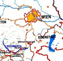
At Hirschwang it reaches its densely populated and strongly regulated middle course, the actual Schwarzatal , and goes south-east, then north-east via Reichenau and Gloggnitz to Ternitz , where it enters the Vienna Basin .
In the lower reaches, it crosses the larger cities of Ternitz and Neunkirchen to the east and is largely canalised. At the eastern edge of Neunkirchen, the Kehrbach is diverted to the Warmen Fischa . The last kilometers of the river are free-flowing floodplains , then at Haderswörth in the municipality of Lanzenkirchen it joins the Pitten coming from the right (south) and forms the Leitha , which already flows into the Danube in Hungary.
To the sources of the Schwarza
From ancient times it was customary to see the sources of the Schwarza on the Rohrer Sattel , which would result in a length of 78 kilometers. This is probably due to the fact that Rohr and Schwarzau belonged to the rule since the 13th century , then to the Gutenstein district court and the "Rohrerberg" was the access - the road through the Höllental was a footpath that was only made mobile in 1832. The channel coming from the Rohrer Sattel is called Mausgraben today .
The question of the Schwarza springs was discussed in the early 19th century. There is also the statement that it originated near the village of Rohr as the confluence of the Klausbach and cell brooks (Güttenberger gave the sources "at the foot of the Unter - and Winsaberges ", so Rainbach- Klausbach and cell brook from Handlesberg in the valleys north and south of the Rohrer saddle ), probably because the main valley, the area , runs from Markt Schwarzau to the village of Rohr and the localities cells Bach are only from Rohr into the valley.
The brooks in the Schwarzauer Trauch were then given (three springs at Trauchbach and in the Wassertal , pastor May around 1830).
As a result, the Schwarzaursprung was then pragmatically moved to the Gschaiderwirt area on the Rohr – Schwarzau municipality border, with cells Bach, Trauchbach and Paxbach as source streams, or the course in the Tiefental Tiefentalerbach is called source stream. This name can be found until the late 20th century.
One of the first to name the sources in the sense of the current official hydrography is a senior teacher Schmatzberger around 1830: "The Green Schwarza in Naglreut and the Dürre Schwarza in Hochreit ". The second is still valid today, the first, from the foot of the Hegerberg , is led as a brook from Werasöd , the Green Schwarza comes west of the Tettenhengst on the other side of Hochreith.
Hydrography
character
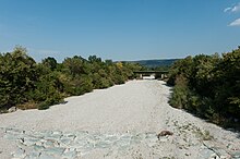
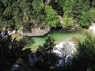
The Schwarza is characterized in the upper reaches by impinging slopes , high bank rocks, gravel banks , pools and deep gullies. The lower reaches to Schwarzau am Steinfeld is heavily regulated. Only between Schwarzau am Steinfeld and Bad Erlach can the Schwarza spread out again in wide meanders . From Loipersbach the Schwarza has an infiltration stretch where most of the water seeps into the gravelly subsoil of the stone field .
The river bed below the Dunkelsteiner Weir in the municipality of Ternitz is usually only water-bearing when the snow melts and when it rains heavily. The water flows through several works canals through the city of Neunkirchen. Some small hydropower plants are driven here.
At the Peischinger (land) weir , most of the water from the Schwarza (max. 7,000 liters per second) is discharged into the Kehrbach , which feeds the Wiener Neustädter Canal.
In heavy rain, when the snow melts and during thunderstorms , the Schwarza can quickly swell into a torrent.
Importance for economy, building
The river was initially of economic importance in the context of logging. The wood of the forests on both sides of Schwarza was from 1803 on the Schwarza and Kehrbach to Wiener Neustadt getriftet , loaded onto barges and the Wiener Neustadt Canal to Vienna brought.
Before that, it was processed into charcoal in large piles at the wind bridge . From the beginning to the middle of the 19th century, numerous factories, especially paper mills , set up shop in the region. Of the once important paper mills, only Mayr-Melnhof Karton (MM Karton) in Hirschwang is in operation today . Numerous plant closings shaped the working and social life of the region in particular. After the closure of the paper mill in Schlöglmühl, a television documentary with the name Postal address 2640 Schlöglmühl was made about the decay of the former paper stronghold.
The Schwarza is also used to generate electricity . For this purpose, several factory canals were built along the Schwarza , through which a large part of the water of the Schwarza flows today. If there is a prolonged lack of precipitation on the lower reaches from the Kehrbach diversion, the Schwarza always falls completely dry . This violates the EU directive on the continuity of rivers ( WFD ), the ecology collapses again and again, but the extraction quotas of the power plants are fixed, so that there is little prospect of improvement. The problem has existed at the Leitha since the 19th century.
Water from the Schwarza catchment area has also been used to supply Vienna with drinking water since the first Viennese spring water pipeline was built from 1869–1873 .
traffic
In the entire course of the river, the B 27 Höllental Straße uses the Schwarzatal. Between Payerbach and Neunkirchen , the Semmering Railway follows the course of the Schwarza. The Lower Austrian Höllentalbahn (now a museum railway) runs between Payerbach and Hirschwang an der Rax .
Natural space
Typical animal species for the Schwarza are: otters , gray wagtails , gray herons , wall creepers , dipper , grayling , brown trout , Koppe (fish) and, recently, the kingfisher again .
It is also noteworthy that in the area of the Schwarza near Kaiserbrunn, the fishing industry has been converted from conventional stocking measures to supporting natural resources. The stock of domestic brown trout in particular is supported by “cocooning” and “artificial nests”. The aim of this project is to build a native and reproductive fish fauna . In particular, the use of “artificial nests” ( spawning beds placed directly in the substrate ) supports the natural occurrence of brown trout.
The Schwarzatalungen from Gschaiderwirt near Rohr and Schwarzau in the mountains down to Gloggnitz are part of the Natura 2000 area of the Northeast Rim Alps: Hohe Wand - Schneeberg - Rax ( FFH area ), which extends to Ternitz in the mountains. Up to Gloggnitz is the whole catchment area and the conservation area Rax-Schneeberg .
Web links
Individual evidence
- ↑ a b c d e f g h Lower Austria Atlas (NÖGIS) → Topics Water Book → Catchment Areas (WLV) and NPG (National Water Management Plan ) → Water bodies ; as well as BMLFUW: Area directory Leitha, Rabnitz and Raab area
- ↑ a b c d The three detailed water body number ranges correspond to the upper, middle and lower reaches: Exact numbers are: 100010-0018 in the Tiefental , -0024 at Gschaiderwirt to Jagerhof, -0024 to Voitsmaut , -0016 to Höllental , -0002 in Höllental to Abbrennbrücke, -0002 to above Hirschwang paper mill ; 100080-0004 to the mouth of the Auebach in Gloggnitz , -0003 to the mouth of the Saubachgraben near Ternitz - Wimpassing ; 100052-0044 to Rohrbach - Dunkelstein , -0043 Neunkirchen to the Kehrbach diversion , -0029 to the mouth.
- ↑ BMLFUW (ed.) : List of areas of the river areas: Leitha, Rabnitz and Raab areas. In: Contributions to Austria's hydrography, issue No. 63, Vienna 2014, pp. 11/29. PDF download , accessed July 7, 2018.
- ↑ For example, "The Schwarza rises on the west side of the Rohrerberg, initially directs its course to the northwest, but bends to the south at the village of Rohr and then flows through an open spring valley, the Schwarzau, ...". Aug. Neilreich: Supplements to the flora of Vienna: an enumeration of the vascular plants growing wild in the surroundings of Vienna or in large vascular plants, together with a plant-geographical overview. Verlag Fr. Beck, 1851, p. 44 ( Google eBook, full view )
- ^ History , schwarzauimgebirge.at
- ↑ a b c d Gustav A. Witt: From the diary of a peasant painter (Johann Ritter). = Volume 10 of the Association for Regional Studies and Heritage Protection of Lower Austria and Vienna (ed.): Our home . New series No. 10/11, 1937 (pp. 282-388); there p. 286
- ↑ 3. Land survey , around 1870; see A. Bittner: From the area around Schwarzau in the mountains. Report of July 31 [1893]. In: Negotiations of the Geol. Ges. No. 10, 1893, pp. 245–247 ( PDF on ZOBODAT ); there p. 246: "The Schwarza River arises near north above Schwarzau through the union of the Rohrer cell stream with the Trauchbach and the Paxwasser."
- ↑ For example the delimitation of the Obersberggruppe (group no. 1843) to Reisalpe – Hegerberg (1399) in the mountain group breakdown according to Trimmel : “Wassertal - Trauchbach - Tiefentalbach - Gschaiderwirt”. Information in Lukas Plan: Verbal description of the delimitation of the subgroups of the Austrian cave directory . Status: Jan 08 2008. Ed .: Association of Austrian Speleologists. ( hoehle.org [PDF; 321 kB ; accessed on May 15, 2018]).
- ↑ a b Schwarza dry: the EU interferes. Thomas Santrucek on mein district.at, August 24, 2015.
- ↑ D. Stur: On the drinking water issue of Neunkirchen. In: Yearbook of the Imperial Royal Geological Institute 39 (1889), pp. 259–280. ( Article, pdf , geologie.ac.at).
