
Unterberg (Gutenstein Alps)
| Unterberg | ||
|---|---|---|
 View to the Unterberg from west-northwest ( Reisalpe ) |
||
| height | 1342 m above sea level A. | |
| location | Lower Austria , Austria | |
| Mountains | Gutenstein Alps | |
| Dominance | 11.5 km → Reisalpe | |
| Notch height | 564 m ↓ Haselrast | |
| Coordinates | 47 ° 56 '18 " N , 15 ° 49' 9" E | |
|
||

The Unterberg is with a height of 1342 m above sea level. A. a striking summit in the Gutenstein Alps in southern Lower Austria . The mountain, which is also popular as a ski area for the Viennese and for ski tours, is located 50 km southwest of Vienna in a mountain range between Triesting and Piestingtal .
Location and landscape
The Unterberg stands about 10 km south of Hainfeld as the westernmost and highest summit of a loose mountain range that comes from the Hocheck ( 1037 m ) and the Kieneck ( 1106 m ). This ridge then continues to the Jochart ( 1266 m ) and then in a row to the Göller-Gippel-Zug and forms the main Alpine ridge here . The Unterberg – Jochart mountain group is demarcated from Unterberg to Jochart . The Unterberg is the north-easternmost mountain in the Alps, which still has a high montane character, and forms the center of the Gutenstein Alps, although it is not their highest mountain, which is the slightly higher Reisalpe to the northwest.
The ridge to the southwest continues, albeit less high, to the Brunntaler Höhe ( 1090 m ) and the ladder walls ( 1025 m ). This ridge leads to the Schneeberg . About 8 km south of the Unterberg lies the Rohrer Sattel ( 864 m ), an important road connection from the Vienna Basin and Piestingtal to the Rax region and the Traisental .
The mountain is made of limestone and has a steep , wooded slope criss-crossed by rock faces on the northwest side , while it slopes much more gently to the southeast.
The Myralucke of the Myrabach rises on the southeast flank of the Unterberg . It forms the picturesque Myra Falls just above Muggendorf and then goes to the Piesting via Muggendorf and Pernitz . To the southwest, the Rohrer Rainbach drains further to the Schwarza . The north side approaches the Kleinzeller Gampmannsgraben on the upper Gölsen . The summit thus belongs to the main Alpine ridge in its northwestern extension.
Big caves are the gold mine and the ridge shaft .
Culture and Development
The Unterberg refuge of the Austrian Tourist Club is located about 150 meters south of the summit . The neighboring Maria Einsiedl chapel houses a copy of the Mariazell statue of Our Lady. The earliest visitors to the Unterberg were pilgrims on the way to Mariazell , but they almost never climbed the summit.
Today the Unterberg is a local winter sports center with three tow lifts and several ski slopes. The ski lifts lead to the summit on the southeast flank; they can be reached from Pernitz in the Piestingtal via Muggendorf. The Unterberg is also very popular as a destination for ski tours .
History of forest use
About the life of the forest farmers on the Unterberg and the trees as their silent witnesses
“The Muggendorf farmers are a good breed of people. They feed on woodwork, coal burning and blacksmith work, ”reports Joseph August Schultes of his wanderings at the beginning of the 19th century.
Early uses of wood
Vienna and the surrounding area had a great need for wood, the Unterberg was not far away, but difficult to access and, not least because of its border location, was planted with primeval forests for a long time. Above all, the lack of suitable means of transport made the use of wood difficult. The wood could not be washed away and, after the Muggendorf office belonged to the Hernstein / Merkenstein lordship, it was even supposed to be brought to Pottenstein via a pass to be 'deposited' there, i.e. to be sold. If the wood was brought through the Myra and Piestingtal valleys anyway, it could only be transported by horse and cart.
Up until the late 19th century there were no passable roads on the mountain, only pilgrim paths. The wood was brought from the forest itself by means of the muscle power of wood chippers, horses or wood giants. Due to the lack of suitable means of transport, the region was probably saved from early large-scale clearcuts from today's perspective.
The life of farmers in earlier times
All farmers outside the center of Muggendorf can be described as forest farmers. In the Lahmweg, at the foot of the Unterberg, almost exclusively wood cutters and charcoal burners settled, their huts were not endowed with land, they worked directly for the Merkenstein rulers , and were also allowed to cut stately wood for their own use.
Their economic basis was mainly the forest. The arable and meadow land offered just enough for their own needs for food for humans and cattle. The slopes were too steep for meadows, but Unterberg and Trafelberg also offered leveling areas (Zueckwiese, Friedlanger, Bindergraben, Trafelwiesen) that were used as meadows.
Wood uses on the Unterberg
Due to the poor transport options, the farmers only had one option to bring wood to the markets in Wiener Neustadt and Pottenstein. They had to process the wood further before selling it. They did so, they produced wine Plug, shingles , Kien and shop for the markets, and charcoal for the iron manufacturing.
After 1848, when the manors were dissolved, the forest areas were divided among the farmers in Muggendorf. Due to the remote location, there were still not many opportunities for the farmers to use the forest on the Unterberg. Where there were pines, the trees were pitched , and the spruce and beech trees were used to produce charcoal. With the charring of the wood, it became significantly lighter and therefore easier to transport.
There are no reports of large-scale clearcuts on the Muggendorf side of the Unterberg, but reports were made about the forest pasture, a form of pasture that did not take place on a fenced-in alpine pasture, but the animals were driven directly into the forest.
Mute witnesses
Today you can also find "silent witnesses" ( terminus technicus ) in nature for the heavy grazing : on the one hand, after the parceling in 1848, border trees (spruce, fir, beech, elm and sycamore maple) were planted on the property boundaries. Today they are the oldest trees on the Unterberg. They have a habit that indicates that these border trees have grown up as solitary trees. In other words, trees that had enough space all around for many decades to develop a long crown with strong branches.
On the other hand, there are particularly distinctive beeches that stand close together in small groups. These are trees that were severely bitten in their youth due to the grazing of the forest that took place until the 1930s. Only later did the beeches have the opportunity to grow through and become large.
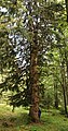
Silent witness: Urbaum

Silent witness: hollow beech

Mute witness: Reserl fir

Silent witness: summit maple


The forest today
In the 20th century, forest grazing and charcoal production disappeared on the Unterberg. The forest recovered. Ultimately, the concept of sustainability prevailed and the forest was managed - rejuvenated, cared for, thinned, harvested. The forest image has changed massively since then. Tourism found its way into both summer and winter. The interest in the forest is still high, as a commercial forest , recreational forest and protection forest .
Picture gallery

Unterberg shelter of the ÖTK ; approx. 150 m below the summit

Summit cross on Unterberg in winter

Postcard from 1911: Skiers in front of the shelter on Unterberg. Ledermann publishing house


Web links
Individual evidence
-
↑ The central role of the Unterberg, there called the “Gschaider” mountain range , within the easternmost northern Alps - but without naming the groups or the Gutenstein Alps as such - is already given by MV Lipold: The coal area in the northeastern Alps. Report on the localized recordings of the I. Section of the Imperial Geological Institute in the summers of 1863 and 1864. Volume I in: Jahrbuch der Kais. Kings Geologische Reichsanstalt , Volume 15, 1865, pp. 18 ff (full article, pp. 1–150) pdf , geologie.ac.at; ( Google eBook, full view ):
"The most and most widely branched mountain range is the one whose junction is 'on the Gschaid', southeast of Kleinzell and northwest of Guttenstein." - ↑ cadastral number 1867/3, Helga and Wilhelm Hartmann: The caves of Lower Austria . Ed .: Regional Association for Speleology in Vienna and Lower Austria. tape 2 . Vienna 1982, p. 156-157 .
- ↑ 1867/5, Helga and Wilhelm Hartmann: Die Höhlen Niederösterreichs . Ed .: Regional Association for Speleology in Vienna and Lower Austria. tape 4 . Vienna 1990, p. 340-342 .
- ↑ www.unterberg-schutzhaus.at
- ^ Joseph August Schultes : Excursions to the Schneeberge in Lower Austria . Ed .: Degenschen Buchhandlung. Vienna 1807, p. 423 .
- ↑ a b Heide Gotsmy: The forest farmers on the Unterberg (Lower Austria) and the trees as their silent witnesses. (PDF; 3.1 MB) Self-published, 2019, accessed on April 22, 2020 .
- ^ Ernst Katzer: Wood for Wiener Neustadt. In: Our new town . tape 25 , no. 1 . Wr. Neustadt 1981, p. 4-7 .
- ^ Lower Austrian Weisthümer: The quarter under the Viennese forest. Ed .: Academy of Sciences, Gustav Winter. 1st part, 1886, p. 389 .
- ^ Erasmus Hofer: Topography of Lower Austria . 1903, p. 910 ff .
- ^ Johann Laister: memorial protocol d. Hft. Merkenstein. Can no longer be found, quoted from Katzer E. 1974: The regional court administrator Johann Laister and his time. In: 900 years of Pottenstein. Self-published by the Pottenstein municipality, pages 177–184 .
- ↑ Ernst Katzer (co-author): Muggendorf in the course of time. Self-published by the Muggendorf community, 1997, p. 395 .
- ↑ a b Heide Gotsmy: The forest farmers on Unterberg (Lower Austria) and the trees as their silent witnesses. In: Museumsmanagement Niederösterreich GmbH (Ed.): Study of regional and local research . In processing.