
Myra falls

The Myra Falls (more rarely: Miraf Falls ; always pronounced with an "i") are located in the municipality of Muggendorf in the federal state of Lower Austria . The gorge is formed by the Myrabach , a small tributary of the Piesting at the foot of the Unterberg .
Origin, history, use


The waterfall is not to be confused with the Mirafall 50 km to the west on the Ötscher. Miragraben is also the name of the valley of the upper Rainbach , from Unterberg westwards to Rohr. This can be reached from here on an old pilgrim path to Mariazell , which leads from here over the Maria Einsiedl chapel (at the Unterberg refuge ). The fact that the valleys or creeks have the same name on both sides of the pass is more common in the Alps.
The Myra , as the brook is also called, rises at the foot of the Unterberg from the legendary Myralucke , a source that is fed by the groundwater of the Unterberg. Although the Myra is only a few kilometers long, it used to drive many mills and sawmills in the Myratal.
In 1899, headed by the Austrian Tourist Club, a movement was formed against “the exploitation of these cases for industrial purposes and thus the destruction of a natural beauty”. In 1898, Oskar Edler von Rosthorn acquired the affected properties in connection with the application for a concession to build and operate an electricity company. With the fact of this ownership, Rosthorn's representative tried in a letter addressed to the Austrian Tourist Club to break the negative attitude of the association or even to reverse it: The club should consider “that the concession seeker also has it in his power, by clearing of the forests that cover the slopes of the ravine to permanently destroy the picturesque beauty of the ravine ”.
On December 17, 1912, the city of Wiener Neustadt decided to vote in favor of the construction of an electricity station. On June 13, 1913, the water law inspection of the Mirabach, which was one of the deciding factors for the "industrial use of the waterfalls", took place. As a result, the real estate bank, who succeeded the original rights holder Oskar Edler von Rosthorn, built a small storage power plant on the Myra Falls, the Myrawerk , which was in operation until 1974/1975.
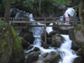
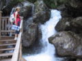
The actual gorge with the waterfalls is about 600 meters long, the difference in altitude is 70 meters. The gorge runs from north to south and is protected as a natural monument. The underground of the gorge consists of limestone . The Myrabach falls in several cascades through the gorge, at the upper and lower end the water is dammed into a small pond .
A well-developed and popular hiking trail leads through the gorge, which was laid out in 1885 by the Austrian Tourist Club, Section Pernitz, with the construction of 19 bridges and 8 stairs (opening: August 9, 1885) and has been looked after since then.
There are two memorial plaques at the entrance to the Myra Falls. The first commemorates the “making the waterfalls accessible and the construction of the climbing systems by the Pernitz section of the Ö.TC”. The second panel is dedicated to “The memory of the highest visit to the Myra Falls by His Majesty the Roman-German on September 19, 1801 Emperor Franz II. , Her Majesty Empress Maria Theresa , as well as Crown Prince Ferdinand Karl Leopold Josef and Archduchess Maria Ludovica - dedicated by the Oest. Tourist Club and the Alpine Society 'Enzian' - June 8th, 1902 ”.
There are restaurants at the top and bottom of the gorge. The entrance to the gorge, about 300 meters north of the village of Muggendorf, is easy to reach on foot or by car (parking lot).
The Myra joins the Piesting shortly after the falls in Pernitz .

The climbing system at the Myra Falls
The climbing system at the Myra Falls
The climbing system at the Myra Falls

Hiking trails at the Myra Falls


Others
On December 7, 1977, the Austrian Post issued a postage stamp from the definitive series Landscapes from Austria with a face value of 20.00 Schilling (1.45 euros) for this motif .
literature
- Franz Xaver Schweickhardt : Mira (fall of) . In: Representation of the Archduchy of Austria under the Ens […] Third Volume, Quarter under the Vienna Woods. Vienna 1831, p. 268 ff . ( Full text in the Google book search - dramatically romantic description of a hike along the then undeveloped Myra Falls).
Web links
- Myra Falls (Muggendorf municipality)
Individual evidence
- ↑ So just south of the Gutensteiner cell brook and the Rohrer cell brook ; Also known is the Wipptal on both sides of the Brenner or the Tauern streams on both sides of the Hohe Tauern and the Felbertauern .
-
↑ Local report. (…) Excursion to the Mira Falls .. In: Das Vaterland , June 8, 1899, p. 11, top left (online at ANNO ). ,
Correspondences. (...) (A "protest party") on the Myra falls (...). In: Badener Zeitung , June 10, 1899, p. 5, center right (online at ANNO ). ,
The future of Mirafalls. In: Badener Zeitung , September 20, 1899, p. 5 middle (online at ANNO ). . - ↑ On the battle for the Mira Falls. In: Badener Zeitung , October 7, 1899, p. 3, center right. (Online at ANNO ). .
- ↑ a b nature conservation. The magnificent Mira Falls (...). In: Der Naturfreund , born in 1913, (17th year), p. 54, center left. (Online at ANNO ). .
- ↑ Inspection of the Mirabach. In: Badener Zeitung , June 11, 1913, p. 5 middle. (Online at ANNO ). .
- ^ Opening of the Myra waterfalls. In: Badener Bezirks-Blatt , August 6, 1885, p. 3, bottom right. (Online at ANNO ). .
- ↑ Landscapes from Austria (Myrafälle, Lower Austria) . In: Austria-Forum , October 25, 2010, accessed on March 15, 2011.
Coordinates: 47 ° 55 ' N , 15 ° 56' E