
Hocheck (Gutenstein Alps)
| Hocheck | ||
|---|---|---|
 Hocheck from west-north-west (south of the Richtberg ) |
||
| height | 1037 m above sea level A. | |
| location | Lower Austria | |
| Mountains | Gutenstein Alps | |
| Dominance | 6.8 km → Kieneck | |
| Notch height | 337 m ↓ Bärental-Tiefental | |
| Coordinates | 47 ° 59 '49 " N , 15 ° 57' 6" E | |
|
||

The Hocheck is 1037 m above sea level. A. high mountain in the Gutenstein Alps in Lower Austria . It is the highest point in the Triestingtal and, at 24 kilometers as the crow flies, it is the 1,000-meter peak closest to the Vienna city limits.
description
The Hocheck is located on the municipal border between Furth an der Triesting and Altenmarkt an der Triesting . It is the highest point of a 10-kilometer mountain range that branches off the main Alpine ridge at Veiglkogel in an easterly direction. From Furth there is a 6.5 kilometer toll road leading to the shelter. The road was closed to traffic for a good year and a half from July 1, 2016, but has been open again since April 28, 2018.
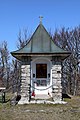
On the summit there is the freely accessible 13-meter-high Meyringer-Warte , immediately below the summit is the Hocheck-Schutzhaus and between the two there is a memorial for mountain comrades who died in the two world wars.
Up until around 1990 there were two T-bar lifts on the south-east side, directly below the Hocheck-Schutzhaus, and once, in 1906, a cogwheel railway leading from Furt im Furtertal to the summit of the Hocheck was also planned, a project that failed due to funding.
Ascents
Numerous climbs lead to the Hocheck, including:
- from Furth via the Krennweg (difference in altitude about 610 m)
- from Altenmarkt via Wieshofersteig (path no.4 and 404; difference in altitude about 620 m)
- from Weissenbach via Eberbach (path no.448; difference in altitude about 670 m)
literature
- Franz and Rudolf Hauleitner: Wiener Hausberge , p. 20 . Bergverlag Rother , Munich 2009, ISBN 978-3-7633-4216-7
- Franz and Rudolf Hauleitner: Viennese hiking trails , p. 48f . Bergverlag Rother, Munich 2006, ISBN 3763330275
photos

The Hocheck shelter

The Meyringer-Warte
The memorial for the deceased mountain comrades

View from the Meyringer-Wart in east direction with the shelter in the foreground and the Leithagebirge on the horizon


Web links
Individual evidence
- ↑ a b The standard from 26./27. January 2008: Editor: A cog railway dreamed, ...
- ↑ Austrian Tourist Club : Meyringer-Warte ( page no longer available , search in web archives ) Info: The link was automatically marked as defective. Please check the link according to the instructions and then remove this notice. ; Retrieved October 30, 2010
- ↑ Photo evidence on Alpinforum.com ; Retrieved October 30, 2010
- ↑ Miscellaneous. (...) New tracks. In: Der Naturfreund , year 1906, year X, p. 179, center left. (Online at ANNO ). .