
Furth on the Triesting
|
Furth on the Triesting
|
||
|---|---|---|
| coat of arms | Austria map | |
 |
|
|
| Basic data | ||
| Country: | Austria | |
| State : | Lower Austria | |
| Political District : | to bathe | |
| License plate : | BN | |
| Main town : | Furth | |
| Surface: | 64.16 km² | |
| Coordinates : | 47 ° 58 ' N , 15 ° 58' E | |
| Height : | 421 m above sea level A. | |
| Residents : | 863 (January 1, 2020) | |
| Population density : | 13 inhabitants per km² | |
| Postal code : | 2564 | |
| Area code : | 0 26 74 | |
| Community code : | 3 06 09 | |
| NUTS region | AT122 | |
| Address of the municipal administration: |
2564 Furth an der Triesting 2 | |
| Website: | ||
| politics | ||
| Mayor : | Alois Riegler ( ÖVP ) | |
|
Municipal Council : ( 2020 ) (15 members) |
||
| Location of Furth an der Triesting in the Baden district | ||
  |
||
| Source: Municipal data from Statistics Austria | ||

Furth an der Triesting is a municipality with 863 inhabitants (as of January 1, 2020) in Lower Austria in the Baden district in Triestingtal .
geography
The municipality is located in a southern side valley of the Triesting Valley and has 795 inhabitants on an area of 64.25 km². The altitude of the place is 422 m above sea level. A.
The Further waters are the Furtherbach, which flows into the Triesting in Weissenbach, and the Klausbach, which flows into the Furtherbach in the Schromenau district. Only at the Rotte Hof in the extreme northeast is the municipality located directly on the Triesting.
The main sources of the water pipeline association of the Triestingtal and Südbahn communities established in 1929 are located in Furth .
mountains
The Kieneck is 1106 m high. In the Further area, the summit lies almost exactly on the municipal boundary between Furth, Muggendorf and Ramsau . The Hocheck is 1037 m high and several hiking trails lead to a lookout point, the Meyringer-Warte , and to the Hocheck-Schutzhaus . The Hocheck is the closest mountain over 1,000 meters from Vienna . At the beginning of the 20th century , a rack railway was planned from Furth , but its implementation failed due to financial problems. A toll road to the refuge, which had been closed for a few years, was reopened in April 2018. Another mountain that can be climbed from Furth is the Gaisstein .
Community structure
The municipality includes the following 11 localities (population in brackets as of January 1, 2020):
- Aggsbach (9)
- Dürntal (28)
- Ebeltal (42)
- Eberbach (24)
- Furth (290)
- Guglhof (6)
- Courtyard (16)
- Maierhof (301)
- Niemtal (88)
- Deer grass (2)
- Steinwandgraben (57)
The community consists of the cadastral community Furth.
Neighboring communities
The municipality of Furth an der Triesting borders on the following other municipalities:
Kaumberg, Altenmarkt an der Triesting, Weissenbach an der Triesting, Pottenstein, Muggendorf and Ramsau
Population development
| census | Residents |
|---|---|
| 2011 | 823 |
| 2001 | 795 |
| 1991 | 745 |
| 1981 | 753 |
| 1971 | 809 |
| 1961 | 820 |
| 1951 | 885 |
| 1939 | 967 |
Source: Population development of Furth an der Triesting. (PDF) Statistics Austria
politics
The municipal council with 15 members has the following distribution with the municipal council elections in Lower Austria 2020 : 15 ÖVP.
- mayor
- 1985–2015 Franz Seewald (ÖVP)
- Alois Riegler since 2015 (active 2015–2020 Furth, ÖVP since 2020)
Culture and sights

- Steinwandklamm : In 1884 the gorge ( location ) was made accessible to visitors and opened on June 8th of the same year with the participation of more than 600 participants from Vienna. The Austrian Tourist Club (Ö.TK) Triestingtal built a via ferrata in 1927. The sentence “We hike in the emperor's footsteps” arose from the fact that Emperor Franz Joseph was probably the most famous hiker in the gorge. It was pretty much destroyed in WWI and WWII . Today secured paths and bridges lead to the Türkenloch ; The inhabitants of the Triesting Valley are said to have hidden there during the second Turkish siege , but after the discovery by the Turks they were all killed by rising smoke.
- Parish church: The parish church Maria Magdalena is located in the middle of the village and is partially surrounded by the former cemetery wall. In 1683 it was destroyed by the Turks and rebuilt by the Minorites in Pottenstein . In 1782 Furth was raised to an independent parish. The building is a low baroque central structure with a rectangular nave and a cross-oval dome. The massive east tower with a steep hipped roof dates from the 15th and 16th centuries. The ceiling painting in the dome with the theme "Jesus and the adulteress" is signed Franz Xaver Dobler 1795.

South view of the parish church
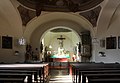
Interior view towards the altar

Interior view towards the gallery

Ceiling fresco by Franz X. Dobler (1795)


economy
Most of the area is forest. Forestry and hunting are therefore important. Furth is a village with Most Mostheurigen and natural juice production setting Countryside drink Krenn KG.
Honorary citizen
- Franz Seewald
literature
- Ernst Nepomucky, Hans Sachs, Sebastian Schertlin: memories of the Turkish battle in Triestingtale in 1532 by Hans Sachs. Verlag des Gymnasialvereines, Berndorf 1932, ONB .
- Walter Rieck: Cultural geography of the Triestingtal. Dissertation. University of Vienna, Vienna 1960, ONB .
- Leo Wirtner: Furth on the Triesting. Municipal office, Furth an der Triesting 1978, UBW .
- Gabriele Handl, Christian Handl: Our Triestingtal. Volume 2: Altenmarkt, Berndorf, Enzesfeld-Lindabrunn, Furth, Hernstein, Hirtenberg, Kaumberg, Leobersdorf, Pottenstein, Weißenbach . Kral, Berndorf 2002, ISBN 3-9501643-2-4 .
- Gerhard Schirmer, Walter Wenzel: Gorges and gorges in Lower Austria . Section “Alpine Society Kienthaler” of the Austrian Tourist Club, Neunkirchen 2005, ONB .
Historical maps
- Furth and the surrounding area around 1872 (recording sheets of the regional survey )

Furth and the Steinwandgraben (left)

The west of Furth, the Steinwandklamm is not yet developed and can only be recognized by the height differences at the end of the Steinwandgraben and at the Türkenlücke (middle left)


Web links
- 30609 - Furth an der Triesting. Community data, Statistics Austria .
- Furth / Triesting website
- Website of the Hocheck shelter (from November 1, 2009)
Individual evidence
- ↑ Source protection forest enterprise Harras. Best water from our own forest . In: wlv-voeslau.at , accessed on January 3, 2014.
- ^ Meyringer-Warte ( Memento from January 2, 2007 in the Internet Archive ). In: oetk.at , June 25, 2006, accessed on January 3, 2014.
-
↑ For the history of the house see:
–tz .: From the area. (...) fire. Hocheckfest. In: Badener Bezirks-Blatt , No. 28/1881 (Volume I), July 9, 1881, p. 7, center left. (Online at ANNO ). .
JH: On the Hocheck. In: Badener Zeitung , No. 32/1911 (XXXII. Year), April 22, 1911, p. 3, bottom left. (Online at ANNO ). .
Local news. (...) On the Hocheck. In: Badener Zeitung , No. 54/1911 (XXXII. Year), July 8, 1911, p. 5, center left. (Online at ANNO ). .
Correspondence. (...) Hocheck extension. In: Badener Zeitung , No. 69/1911 (XXXII. Year), August 30, 1911, p. 6, bottom left. (Online at ANNO ). .
Local news. (...) The opening of the extension to the Hocheckhaus. In: Badener Zeitung , No. 72/1911 (XXXII. Year), September 9, 1911, p. 5, center right. (Online at ANNO ). . - ↑ Statistics Austria: Population on January 1st, 2020 by locality (area status on January 1st, 2020) , ( CSV )
- ↑ Elfi Holzinger: One vote decided Franz Seewald (ÖVP) no longer competed. The new local chief is Alois Riegler from “Furth aktiv” with a majority of 1 vote. NÖN Baden, March 10, 2015
- ^ News from the districts. (...) Steinwand Gorge. In: Badener Bezirks-Blatt , No. 25/1884 (Volume IV), March 25, 1884, p. 1, bottom right. (Online at ANNO ). .
- ↑ Little Chronicle. (...) The opening of the Steinwandklamm. In: Neue Freie Presse , Abendblatt, No. 7107/1884, June 10, 1884, p. 1, bottom center. (Online at ANNO ). .
-
^ News from the districts. (...) Opening of the Steinwand Gorge. In: Badener Bezirks-Blatt , No. 46/1884 (Volume IV), June 7, 1884, p. 5, bottom right. (Online at ANNO ). ;
Vienna, June 9th. (...) Opening of the Steinwand Gorge. In: Local-Anzeiger der "Presse" , supplement to No. 159/1884 (XXXVII. Year), June 10, 1884, p. 9 (unpaginated) middle. (Online at ANNO ). .

Alland | Altenmarkt an der Triesting | Bad Vöslau | Bathing | Berndorf | Blumau-Neurißhof | Ebreichsdorf | Enzesfeld-Lindabrunn | Furth an der Triesting | Günselsdorf | Heiligenkreuz | Hernstein | Hirtenberg | Klausen-Leopoldsdorf | Kottingbrunn | Leobersdorf | Mitterndorf an der Fischa | Oberwaltersdorf | Pfaffstätten | Pottendorf | Pottenstein | Reisenberg | Schönau an der Triesting | Seibersdorf | Sooss | Tattendorf | Teesdorf | Traiskirchen | Trumau | Weissenbach an der Triesting
Cadastral municipalities: Furth
Locations: Aggsbach | Dürntal | Ebeltal | Eberbach | Furth | Guglhof | Yard | Maierhof | Niemtal | Deer grass | Stone wall ditch
Villages: Furth | Niemtal Weiler: Kienthal Rotten: Aggsbach | Dürntal | Ebeltal | Eberbach | Yard | Lerchenfeld | Maierhof | Deer grass | Schromenau Scattered Houses: Furthergraben | Harras | Staff | Steinwandgraben groups of houses: Prymhäuser | Rohrbach
Counting district: Furth an der Triesting