
Neuberg (municipality of Neuberg an der Mürz)
|
Neuberg an der Mürz ( market ) village Alpl, village, Neudörfl cadastral community Neuberg district |
|||
|---|---|---|---|
|
|||
| Basic data | |||
| Pole. District , state | Bruck-Mürzzuschlag (BM), Styria | ||
| Judicial district | Mürzzuschlag | ||
| Pole. local community | Neuberg an der Mürz | ||
| Coordinates | 47 ° 39 '48 " N , 15 ° 34' 44" E | ||
| height | 730 m above sea level A. | ||
| Residents of the village | 934 (January 1, 2017) | ||
| Building status | 420 (approx., 2017 ) | ||
| Area d. KG | 32.9 km² | ||
| Statistical identification | |||
| Locality code | 15958, 15960, 15963 | ||
| Cadastral parish number | 60518 | ||
| Counting district / district | Alpl-Dorf, Alpl-Dorf-Umgebung (62122 000, 001) | ||
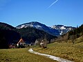
 Neuberg, seen from the Schneealpe transmitter: left-front Neudörfl, in the middle Alpl, above the Roseggerstraße settlement, left the monastery (the village is largely covered) |
|||
|
Village: 253 inhabitants (2017), with Neuberg Cistercian Abbey (without counting); Alpl with Schlapfen : 592 PE (2017); Neudörfl 89 EW (2017) Source: STAT : Local directory ; BEV : GEONAM ; GIS-Stmk ; |
|||

Neuberg an der Mürz is a place in the Upper Mürz Valley in Styria as well as the main town and cadastral community of the municipality of Neuberg an der Mürz in the Bruck-Mürzzuschlag district . It is made up of the three localities Alpl , Dorf and Neudörfl .
In 2015 the community was expanded to include three neighboring communities, since then the original community has been run as the Neuberg an der Mürz district of the community.
geography
Neuberg is located about 36 kilometers northeast of Bruck an der Mur , a good 9 km northwest of Mürzzuschlag . It is located in a basin on the upper reaches of the Mürz in the Mürzsteg Alps , part of the Northern Limestone Alps . In the west rises the Veitschalpe ( 1981 m above sea level ), in the north the Schneealpe ( 1903 m above sea level ), in the northeast the Raxalpe ( 2007 m above sea level ).
The market town of Neuberg an der Mürz is located in the center of the municipal area an der Mürz, at an altitude of 730 m above sea level. A. , at the foot of the Rabenstein valley ( 1027 m above sea level ), an old river meander remnant. The Grünkogel ( 1812 m above sea level ), the southern ridge of the Schneealpen massif, rises above it . Opposite is the Arzbachhöhe ( 1012 m above sea level ), a vorlapf of the Hocheck ( 1418 m above sea level ), which belongs to the Roßeck group , the eastern subgroup of the Veitsch. The place as a whole comprises about 420 buildings with almost 950 inhabitants.
Neuberg is made up of three districts: the village lies elongated on the left bank of the Mürz, south of the Cistercian monastery . It forms the nominal municipality capital . Alpl includes the northern districts on both sides of the Mürz, around Hauptplatz and Kirchsteig. The north-eastern locations on the left of the Mürz, around Neudörflstrasse up, are called Neudörfl . The originally separate places have now grown together completely.
The village of Dorf comprises around 140 buildings and 250 residents. The small Rotte Schlapfen to the north above belongs to the village of Alpl (approx. 230 buildings and 600 inhabitants) . The village of Neudörfl has around 50 buildings and 90 residents. The Alpl-Dorf district of the municipality corresponds to the place as a whole .
The cadastral community of Neuberg extends far beyond the locality, north to the Farfel below the Grünkogel ( 1418 m above sea level ) on the Schneealm, and south to the Hochegg ( 1418 m above sea level ) and the Roßkogel ( 1479 m above sea level ). It has an extension of over eight kilometers and an area of 3,290 hectares . Lechen (out of the valley), the three southern side valleys of Hirschbach , Arzbach and Veitschbach , and half of Karlgraben in the northern side valley of Mürzinward are also located in the cadastral area .
The former community also includes the cadastral community and village of Krampen , the areas on the Mürz in the valley from Neuberg. The four other localities (Hirschbach belongs to Lechen, Karlgraben to Krampen) are summarized in the Alpl-Dorf-Umgebung counting district. This former municipal area also forms the current district.
- Neighborhoods, cadastral communities and places
|
Staples (KG) |
Slacking |
|
|
Mürzsteg (KG)
|
.svg)
|
Altenberg (KG)
Greith (O, KG Altenberg) |
|
Veitschbach (O)
Kleinveitsch (KG, Gem. St. Barbara i.Mzt. )
(both Gem. Krieglach )
|
Arzbach (O) Feistritzberg (KG) ∗∗ / Mitterberg (KG) ∗∗ / Hönigsberg |
Lechen (O)
Chapels (KG) |
- ∗ Location of the mountain huts that belong to Altenberg
- ∗∗ both only approx. 100 m adjacent to the Roßkogel
History, economy and infrastructure

In 1327 Duke Otto the Merry founded a Cistercian abbey, Neuberg Monastery . This formed the core of the settlement in what was then the Cerewald , the Semmering region, and was also the seat of the deanery. Originally, the term village did not include the monastery, but only the secular settlement around it. The first village church was the Anna Chapel on Kreuzberg, built by the abbot around 1420. Starting in 1477, the Church of the Assumption of Mary was built “on the green Anger ” in Alpl for a local brotherhood. It became the new parish church and the core of the upper village.
In 1379, with the Neuberger partition agreement concluded here between the Albertine and Leopoldine lines of the Habsburgs, the division of the possessions was resolved. It was not until 1496 that Emperor Friedrich III. could be ended for his son Maximilian I.
The economy of the place consisted in the Middle Ages and the early modern period mainly in agriculture and forestry, mining on iron and useful stone, and the trade between Mariazell and Semmering area. The road of the upper Mürz Valley is now the B23 Lahnsattelstraße , which comes from Mürzzuschlag and leads through the village, and then continues over the Lahnsattel to the B21 , which connects the Mariazellerland with the Traisental .
In 1786 the monastery was secularized under Josephinism, and the collegiate church, called "Cathedral in the Village", became the parish church. The monastery building became the administrative seat of the forest and mining administration.
In the 19th century, more industrial iron mining began, interrupted by the enormous devastation caused by a storm in 1820. Around 1840 there were three heavy-duty hammers , an artificial hammer , a stretching hammer and a puddling mill , a smelting works in Karlgraben , an iron pounding furnace and a pounding mill in Tyrol . The Mürzzuschlag-Neuberger Bahn was built up to this point in 1876 (discontinued in 1996/2000). In Arzbach the Veitscher Magnesitwerke-A. G. a smaller dismantling until 1930.
After the world wars, however, the iron and steel industry declined, and tourism began to become increasingly important in Vienna's local mountains . Today Neuberg is primarily a tourist destination. The former Cistercian abbey was used for the Styrian State Exhibition in 1996 and was then sold to a private investor and is operated as an event location. The Gasthof Holzer was awarded two toques in 2005. There is also a youth hostel, a soccer field, a tennis court, a skate fun park and a natural swimming pond in the village. There are also three hydropower plants and a heating plant.

Martinofen ironworks, 1913

around 1960; in the foreground the station building

January 2012


Culture and sights

The main attraction is the former Cistercian abbey with the wing of the imperial hunting lodge . Here you will find the Imperial Museum , the Kaiserhof Schauglashütte , the Nature Museum - the Schliefsteiner Collection , the Pölzl Museum.
Other buildings:
- Church '' Maria Himmelfahrt am Grüne Anger '' : Gothic hall church
- Former Anna Chapel : remains of a Gothic hall church that was converted into a residential building
- The municipality of Neuberg acquired the historic station building in 2009, with the aim of keeping the imperial waiting room accessible to the public .
Other exhibitions in the area are the Holzer local history museum, the Pillhofer sculpture hall by a local sculptor, and the Kaiserhof glass factory (glass blowing).
Important events are the Neuberger Kulturtage and Neuberger Herbst , now an insider tip for high-quality seminars and events among artists and art lovers. The Neuberg cabaret spring has also established itself for several years .
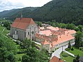
Cistercian Abbey
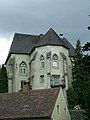
Remains of the Anna chapel
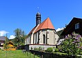
Grünanger Church

Meierhof at the Grünanger Church
Neuberg Abbey seen from the Schenkfeld promenade

The Marterl on the way to the Loisbauer

The new Kuhhörndlbrücke opened in 2006
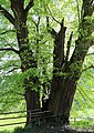
Old summer linden tree in Arzbach


literature
- Georg Goeth: The Duchy of Styria: geographically-statistically-topographically represented and provided with historical explanations. Volume 1 (Brucker Kreis, 1st part), Verlag Heubner, 1840, chapter Steuergemeinde Neuberg , p. 329 ff ( digitized, Google, full view ) - detailed contemporary description.
proof
- ↑ a b Institution residents, including religious, are in principle not recorded in the Austrian official statistics, so they are not included in the population
- ↑ a b Population on January 1, 2017 by location. Statistics Austria (pdf).
- ↑ a b According to the official register of places (Austria) (2001) from Statistics Austria, village is only one place and consists of the place Neuberg an der Mürz and the Cistercian monastery Neuberg .
- ↑ This is described contemporary as: "In the cemetery there is a small wooden chapel with old German paintings and two very old carved candlesticks". Quotation from Lit. Goeth, 1840, p. 336.
- ↑ www.katholische-kirche-steiermark.at: The cathedral in the village - Neuberg parish. Retrieved November 27, 2017 .
- ↑ a b Lit. Goeth, 1840, p. 330.
- ↑ Magnesit-Industrie and Bergbau-AG In: Jubilee book 70 years of Veitscher Magnesitwerke. o. D. Chapter Participations, c) , p. oA ( web extract , veitsch.at).
- ↑ Old station new again . In: kleinezeitung.at , October 5, 2011, accessed on March 23, 2011.
- ^ Website Neuberger Kulturtage

Cadastral communities: Altenberg | Frein an der Mürz | Chapels | Staples | Mürzsteg | Neuberg
Districts (municipality structure) : Altenberg an der Rax | Chapels | Mürzsteg | Neuberg an der Mürz
Locations: Alpl | Altenberg | Arzbach | Dobrein | Village | Dürrenthal | Frein an der Mürz | Greith | Kaltenbach | Chapels | Staples | Lanau | Lechen | Mürzsteg | Neudörfl | Niederalpl | Raxen | Stake | Steinalpl | Bumpers | Tebrine | Veitschbach
Market place: Neuberg an der Mürz | Villages: Alpl • Chapels • Krampen • Mürzsteg • Neudörfl | Hamlet: Hinterleitner | Mitterbachstall • Rotten: Altenberg an der Rax • Dobrein • Frein an der Mürz • Gschwandt • Hirschbach • Kaltenbach • Karlgraben • Knappendorf • Lanau • Niederalpl • Schlapfen | Settlement: Lichtenbachsiedlung | Scattered houses: Arzbach • Bärntal • Dietlergraben • Dürrenthal • Greith • Kerngraben • Kohlbachgraben • Koglergraben • Lechen • In der Naß • Lohmgraben • Mitterbach • Preiner Gscheid • Rax • Raxen • Schneealpe • Scheiterboden • Steinalpl • Stojen • Tebrin • Tirol • Veitschbach • Tebrin • Tirol • Veitschbach Waldbach | Other locations: Auhof • Donaulandhütte • Eisernes Törl • Gamsecker Hütte • Hinteralm • Mürzsteg hunting lodge • Karl-Ludwig-Haus • Lurgbauerhütte • Michlbauerhütte • Raxkircherl • Reisstalerhütte • Schneealpenhaus • Waxriegelhaus • Wiener teachers hut • Zimmermannhütte • Cistercian monastery Neuberg
Counting district: Alpl-Dorf | Alpl village area | Altenberg an der Rax | Chapels | Mürzsteg
Former communities: Altenberg an der Rax 1850–2014 | Chapels 1850–2014 | Mürzsteg 1850-2014