
Mürzsteg
|
Mürzsteg ( village ) locality cadastral community Mürzsteg district |
|||
|---|---|---|---|
|
|||
| Basic data | |||
| Pole. District , state | Bruck-Mürzzuschlag (BM), Styria | ||
| Judicial district | Mürzzuschlag | ||
| Pole. local community | Neuberg an der Mürz | ||
| Coordinates | 47 ° 40 ′ 32 " N , 15 ° 29 ′ 31" E | ||
| height | 782 m above sea level A. | ||
| Residents of the village | 139 (January 1, 2020) | ||
| Building status | 86 (addresses 2018 ) | ||
| Area d. KG | 84.27 km² | ||
| Post Code | 8693 Mürzsteg | ||
| prefix | + 43/3859 ( Mürzsteg ) | ||
| Statistical identification | |||
| Locality code | 15946 | ||
| Cadastral parish number | 60516 | ||
| Counting district / district | Mürzsteg (62144 004) | ||
|
Capital of the municipality of Mürzsteg until 2014 Source: STAT : Local directory ; BEV : GEONAM ; GIS-Stmk |
|||

Mürzsteg is a place in the Upper Mürz Valley in Styria, as well as a locality and cadastral municipality in the municipality of Neuberg an der Mürz in the Bruck-Mürzzuschlag district .
1849-2014 Mürzsteg formed an independent municipality , from 1948 together with Frein an der Mürz . Since then it has been run as a district of the municipality.
geography
Mürzsteg is located about 34 kilometers northeast of Bruck an der Mur , 15 km northwest of Mürzzuschlag , and about 17 km southeast of Mariazell . It is located on the upper reaches of the Mürz in the Mürzsteg Alps , part of the Northern Limestone Alps . In the southwest the Veitschalpe rises ( 1981 m above sea level ), in the northwest the Tonionalpe ( 1699 m above sea level ), in the east the Schneealpe ( 1903 m above sea level ).
The village of Mürzsteg is located 7 km north-west of Neuberg , upstream of the Mürz, at the confluence of the Dobreinbach in the Mürz, on both sides of the river in a widening to around 780 m above sea level. A. Height. As a separate village, the place comprises around 85 addresses with around 230 inhabitants. To the village also the Hinteralm northeast at Waxenegg, another 14 addresses.

The cadastral community of Mürzsteg is much more extensive with 8,427 hectares : In the south and west it comprises the entire area from the Veitschbachhöhe ( 1810 m above sea level ) above Neuberg, the plateau edge of the Veitsch over the Niederalpl pass ( 1221 m above sea level ) , the southern flank of the Tonion over to Proles ( 1565 m above sea level ) and down into the Mürzengtal near the Toten Weib . To the east it stretches along the entire left side of the Mürz, from Riesbrücke on the Veitschbachhöhe over the Schneealp foothills of the Lachalpe ( 1590 m above sea level ), the Hinteralm, the Hochalpl ( 1514 m above sea level ) and the Rosskogel ( 1524 m above sea level). A. ), to the point near Neuwald , where Cold Mürz and Stille Mürz merge to form Mürz. Here is the Lower Austrian border.
This cadastral area also includes the villages of Lanau , Dürrenthal and Tebrin Mürzabwärts, Dobrein and Niederalpl upstream of the dobreinbach, and Scheiterboden upstream of the Mürz River.
Neighboring locations
|
Halltal (KG, Gem. Mariazell ) ∗ |
Frein (KG) Stake (O) |
|
|
Dobrein (O)
Aschbach (KG, Mariazell district )
|
.svg)
|
Staples (O and KG)
|
|
Kleinveitsch (KG, Gem. St. Barbara i.Mzt. ) |
Lanau (O)
Neuberg
(KG) |
- ∗ Halltal is only a little bit adjacent.
- ∗∗At one point there the KG lordship grounds , Gem. St. Aegyd a.Neuwalde , district Lilienfeld , Lower Austria ; the place Altenberg is located much south of Neuberg, but its cadastral area stretches along the state border to the Kalte Mürz.
history

In the later Iron Age, the area, like the entire Mürz Valley, was populated by Celts . The Mürzsteg area was given to St. Lambrecht Abbey by the Carinthian dukes in 1103 . Since then, the area has been cleared and settled from the west by subservient farmers of the monastery. In 1342 the area came to the Cistercian monastery Neuberg . Mürzsteg was first mentioned in a document in 1428.
In 1692, the Neuberg monastery established the iron industry in the area, which experienced a significant boom, especially at the end of the 18th century. Around 1790 there was a work at the confluence of the Dobreinerbach with two plug-in hammers and a chipping hammer upstream ; In 1798/99 the kk rifle factory was founded in Lanau with 64 blacksmiths. In 1850, however, the Lanau factory was closed; the previous mining in Tebrin was also discontinued. After the abolition of Neuberg Monastery, Mürzsteg became its own parish in 1785. It was not until 1861 that the existing chapel Sorrowful Mother was expanded into a church and expanded again in 1898.
From 1850 Emperor Franz Joseph I came regularly to hunt at Mürzsteg; In 1854 he spent his honeymoon here with Empress Elisabeth . The hunting lodge built in 1868 was gradually expanded and converted into a hunting lodge. In 1902 and 1903 he received Tsar Nicholas II here for political deliberations.
James Joyce mentioned Mürzsteg in his novel Ulysses , published in 1927 , incorrectly as Mürzsteg in Lower Austria.
Former parish
Mürzsteg (former municipality) |
|
|---|---|
| Basic data | |
| Pole. District , state | Bruck an der Mur (until 1902) / Mürzzuschlag (MZ, until 2013), Styria |
| Judicial district | Mürzzuschlag |
| Coordinates | 47 ° 42 ' N , 15 ° 28' E |
| surface | 108.6 km² |
| Statistical identification | |
| Community code | 61310 |
| Counting district / district | Mürzsteg (61 310 000) |
| 1849–2014, then part of Neuberg an der Mürz ; Cadastral municipalities: Mürzsteg , Krampen (until 1948, then Neuberg); Frein (from 1948, previously Halltal, Bez. Bruck adM); Locations: 8 to 1948, then 9; Main town: Mürzsteg Source: STAT : Directory of places ; BEV : GEONAM ; GIS-Stmk |
|
The former tax municipality of Mürzsteg became an independent political municipality with the creation of the local municipalities in 1848/49 . It belonged to the Bruck an der Mur district until 1902 , then to the Mürzzuschlag district , and after 2013 briefly to the new Bruck-Mürzzuschlag district. In 1948 Frein an der Mürz was separated from the Halltal community and merged with Mürzsteg; for this purpose, the district of Krampen was reassigned to Neuberg an der Mürz. Since 2015, Mürzsteg has been incorporated into the municipality of Neuberg an der Mürz together with the previously independent municipalities of Altenberg an der Rax and Kapellen as part of the Styrian municipal structural reform.
The localities of the municipality were: Dobrein , Dürrenthal , Frein an der Mürz (from 1948), Kaltenbach (from 1948), Krampen (until 1948), Lanau , Mürzsteg ( main town ), Niederalpl , Scheiterboden , Tebrin .
Neighboring communities were last starting from the north in a clockwise direction: in Lower Austria: Sankt Aegyd am Neuwalde ; in Styria: Altenberg an der Rax , Neuberg an der Mürz , Veitsch , Gußwerk , Halltal .
- politics
The municipal council last had 9 members, the distribution of seats since the municipal council election in 2010 was 5 SPÖ , 2 ÖVP , 2 FPÖ ; 2005: 6 SPÖ, 2 ÖVP, 1 FPÖ. . The last mayor was Karlheinz Mayer (SPÖ) until December 31, 2014. Vice Mayor was Arnold Gamsjäger (SPÖ).
- coat of arms
Blasonierung (Coat description): In a silver five snow roses sprinkled green field under a silver Staghelm a silver web formed on the edges of the plate foot abutting, black grooved, silver retaining walls rests, between which in blue to silver a pike pole and a mountain pick obliquely cross.
The municipal coat of arms was awarded with effect from June 1, 1997. With the church merger, it became obsolete as such.
- Population development
| Population development of the municipality | ||||
|---|---|---|---|---|
| year | Pop. | year | Pop. | |
| 1869 | 1398 | 1951 | 1099 | |
| 1880 | 1270 | 1961 | 993 | |
| 1890 | 1317 | 1971 | 813 | |
| 1900 | 1166 | 1981 | 634 | |
| 1910 | 1125 | 1991 | 652 | |
| 1923 | 936 | 2001 | 554 | |
| 1934 | 943 | 2011 | 565 | |
| 1939 | 879 | 2017 | 478 | |
| Source: Statistics Austria | ||||
The population of Mürzsteg had steadily declined since the beginning of the censuses with individual interruptions (especially between 1939 and 1951, due to the incorporation of Frein) and in the last census in 2001 no longer even made up half of the 1869 number. Both the birth balance and the migration balance were negative in the past decade as well . Since then, the population has increased again slightly and was 631 on January 1, 2012, but most recently again 565 inhabitants on October 31, 2013. ( Mürzzuschlag judicial district and in the political district of Bruck-Mürzzuschlag ).
- Religions
The largest religious community is the Roman Catholic Church , to which 69.7% of the population profess, the second largest, due to the asylum seekers' home, Islam with 8.7%, followed by the Evangelical Church with 7.6% and the Orthodox Church with 1 , 8% of the population. 11.4% are without religious belief.
Economy and Infrastructure

Mürzsteg's economy consists mainly of tourism. The area has been part of the Mürzer Oberland Nature Park since 2003 .
traffic
Mürzsteg can be reached from Mürzzuschlag and Neuberg via the Lahnsattelstraße B23, which then meets the Gutensteiner Straße B21 via the Lahnsattel , on the one hand the Mariazellerland and on the other hand St. Aegyd am Neuwalde and the Traisental can be reached. From Mürzsteg, state road 113 also leads in a westerly direction via Niederalpl into the Aschbachtal to Wegscheid . There she meets Mariazeller Straße B20 (St. Pölten - Mariazell - Seeberg - Kapfenberg).
Established businesses
The Kinderhotel Appelhof is the largest hotel in Upper Styria and occupies the entire south side of the main town with around twelve hectares of hotel grounds. In Frein there is the Freinerhof . On the Niederalpl , a leisure hotspot with three restaurants is developing around the Niederalpl ski lift , which, in addition to the local population, is mainly visited by Viennese. In addition to the traditional Plodererhof with the wooden box, there is a design hotel on the Niederalpl .
Culture and sights
- Jagdschloss Mürzsteg : The former imperial castle has served as the summer residence of the Austrian Federal President since 1947 and is not open to the public.
- Holzknechtmuseum
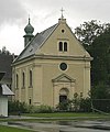
Parish church (listed)

Rectory (listed)

Hunting lodge (listed)

School (listed)

Workers' house in Lanau (listed)


.JPG)


- Waterfall to the Dead Woman , natural monument
Personalities
- Peter Hochegger (* 1949), communications entrepreneur and lobbyist
literature
- Franz F. Seidl: Mürzsteg through the ages. Self-published by the municipality, 1995.
Web links
Individual evidence
- ^ Raimund Karl : The lower ten thousand . Contributions to the prehistory and early history of Central Europe 47, Langenweißbach: Beier & Beran 2007
- ↑ Meinhard Rauchsteiner: Leopold Bloom - a real Austrian , Der Standard , June 12, 2009
- ↑ Announcement of the Styrian state government of November 21, 2013 on the unification of the market community Neuberg an der Mürz and the communities Altenberg an der Rax, Kapellen and Mürzsteg, all political district Bruck-Mürzzuschlag. Styrian Provincial Law Gazette of December 6, 2013. No. 148, 35th issue. ZDB ID 705127-x . P. 680.
- ↑ Communications from the Styrian State Archives 48, 1998, p. 54.
- ↑ State of Styria: Final population status on October 31, 2013 ( Memento of the original from April 15, 2015 in the Internet Archive ) Info: The archive link was inserted automatically and has not yet been checked. Please check the original and archive link according to the instructions and then remove this notice. (Excel file, 85 kB; accessed on May 2, 2015)
- ↑ Holzknechtmuseum ( Memento of the original from January 10, 2016 in the Internet Archive ) Info: The archive link has been inserted automatically and has not yet been checked. Please check the original and archive link according to the instructions and then remove this notice.

Cadastral communities: Altenberg | Frein an der Mürz | Chapels | Staples | Mürzsteg | Neuberg
Districts (municipality structure) : Altenberg an der Rax | Chapels | Mürzsteg | Neuberg an der Mürz
Locations: Alpl | Altenberg | Arzbach | Dobrein | Village | Dürrenthal | Frein an der Mürz | Greith | Kaltenbach | Chapels | Staples | Lanau | Lechen | Mürzsteg | Neudörfl | Niederalpl | Raxen | Stake | Steinalpl | Bumpers | Tebrine | Veitschbach
Market place: Neuberg an der Mürz | Villages: Alpl • Chapels • Krampen • Mürzsteg • Neudörfl | Hamlet: Hinterleitner | Mitterbachstall • Rotten: Altenberg an der Rax • Dobrein • Frein an der Mürz • Gschwandt • Hirschbach • Kaltenbach • Karlgraben • Knappendorf • Lanau • Niederalpl • Schlapfen | Settlement: Lichtenbachsiedlung | Scattered houses: Arzbach • Bärntal • Dietlergraben • Dürrenthal • Greith • Kerngraben • Kohlbachgraben • Koglergraben • Lechen • In der Naß • Lohmgraben • Mitterbach • Preiner Gscheid • Rax • Raxen • Schneealpe • Scheiterboden • Steinalpl • Stojen • Tebrin • Tirol • Veitschbach • Tebrin • Tirol • Veitschbach Waldbach | Other locations: Auhof • Donaulandhütte • Eisernes Törl • Gamsecker Hütte • Hinteralm • Mürzsteg hunting lodge • Karl-Ludwig-Haus • Lurgbauerhütte • Michlbauerhütte • Raxkircherl • Reisstalerhütte • Schneealpenhaus • Waxriegelhaus • Wiener teachers hut • Zimmermannhütte • Cistercian monastery Neuberg
Counting district: Alpl-Dorf | Alpl village area | Altenberg an der Rax | Chapels | Mürzsteg
Former communities: Altenberg an der Rax 1850–2014 | Chapels 1850–2014 | Mürzsteg 1850-2014