Dead woman
| Dead woman | ||
|---|---|---|
|
Karst spring with waterfall "to the dead woman" |
||
| Coordinates | 47 ° 43 '45.1 " N , 15 ° 29' 14.6" E | |
|
|
||
| place | Mürzsteg | |
| height | approx. 40 m | |
| Estuarine waters | Mürz → Mur | |
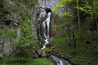
The Dead Woman , also called the Waterfall to the Dead Woman , is a waterfall designated as a natural monument near Mürzsteg in Styria in Austria .
etymology
It is not known exactly where the name Dead Woman comes from. Various legends speak of a woman falling from the rock face and lying dead on the bottom of the gorge running there. It is more likely that the name, like the Dead Mountains , goes back to the Celtic Teutates , which was the generic term for the respective tribal deity. Any kind of source was sacred to the Celts as access to the otherworld .
description
The waterfall is located south of Frein an der Mürz in the Mürzer Oberland Nature Park on the left bank of the Mürz River , which cuts through the syncline almost to its bottom. The water rises from an active water cave in the Schneealpenstock , the southern entrance portal of which forms a karst spring in the rock. Immediately afterwards the water falls down the 40 m high waterfall and subsequent cascades and flows into the Mürz flowing below. The spring pours between 30 and 300 l / s. In the past, you could climb up to the karst hole using wooden stairs that no longer exist.
traffic
The original street led along the left bank of the Mürz river and overcame the waterfall's drain with a small bridge, the bridgeheads of which can still be seen today. When Empress Elisabeth broke through a rotten bridge plank with her horse, the construction of the road connection on the right bank began, which was opened in 1884 and later became Lahnsattel Strasse . The road tunnel “Totes Weib”, built in 1996, was named after the waterfall and bypasses the narrow and damp area at the waterfall. The old road can still be used as a footpath and bike path, and there is a parking lot at the south portal of the tunnel, from which you can easily get to the point opposite the waterfall.
Origin of the water
The water that rises from the karst spring at Toten Weib comes from creeks that sink southeast on the Hinteralm . They meander wildly through the Naßköhr moors lying on the plateau. At 4.5 km², these are the largest moor complex in the eastern Limestone Alps . Due to the glacial shape of the Naßköhr, which is about 50 m deeper, the water cannot run off above ground, but runs off underground in several places.
The largest of these swallowing holes are the so-called "diarrhea" and the "Haselboden". The diarrhea is a three-meter-tall rock gate into which the Naßköhrbach flows and disappears underground. In the event of heavy rain, the rock portal can be completely submerged, so that a backwater reservoir forms. The Ponor on the Haselboden takes up another whole stream. The water that sinks there flows away underground, sloping towards the north. A part reappears in the dead woman; Another rises from a large overflow spring and flows into the Kalte Mürz.
See also
Web links
Individual evidence
- ^ Georg Rohrcker , Die Kelten Österreichs, Pichler Verlag, 2003, p. 85, ISBN 3-85431-317-9 .
- ↑ Helmut Birkhan : Celts. Attempt at a complete representation of their culture. Publishing house of the Austrian Academy of Sciences, Vienna 1997, ISBN 3-7001-2609-3 .
- ↑ Harald Hitz, Helmut Wohlschlägl : Eastern Austria and neighboring regions , ISBN 978-3-205-78447-0 , p. 303.
- ↑ Stadtplandienst.at
- ↑ Sonja Latzin: Das Naßköhr - the fascination of moorland and geological formation. In: Naturpark Akademie Steiermark: Bildungsbericht January to June 2012, p. 6 ( PDF file; 2 MB ( Memento of the original from July 14, 2014 in the Internet Archive ) Info: The archive link has been inserted automatically and has not yet been checked. Please check the original - and archive link according to the instructions and then remove this note. )
- ↑ Linda Reimoser, Gert Michael Steiner: Das Naßköhr - Basics for a new Ramsar area. In: Moors from Siberia to Tierra del Fuego. In: Stapfia. Volume 85, Linz 2005, pp. 535-586, PDF (5.3 MB) on ZOBODAT


