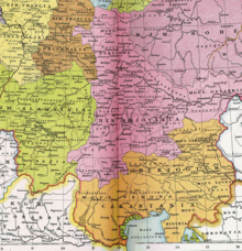
Mark on the Mur
The Mark an der Mur , also Karantanermark , Kärntnermark , marchia Carantana , marchia transalpina , Mark Hengist , Hengistgau or similar, is considered the home country of Styria . The name marchia Carantana appears from the year 970 and is in use until after 1055. Long after 1056, the beginning of the rule of the Traungau people , who originally had their headquarters in Steyr , the current name of Styria gradually established itself .
prehistory
The territory of today's Styria and Carinthia was settled by the Alpine or Karantan Slavs , who founded the Slavic Principality of Carantania , from the end of the 6th century . After their submission to Bavaria in 772, Karantanien was annexed to the Frankish Empire in 788. Charlemagne crushed the Avar great power 795, the extended Franks deep into the Pannonian region to the lower reaches of the Raab and created a Caranthania and Pannonian province , both under Frankish administration, whose common border through the middle of Styria, east of Mur run, should be. In 894 the Hungarians broke into the Danube and Tisza lowlands and tore open the entire south-eastern flank of the Frankish Empire. Not only was Pannonia lost to Eastern Franconia in 907, but also Carantania up to the Fischbacher Alpen , Glein , Stub and Koralpe line .
The victory of Otto the Great over the Hungarians in the Battle of Lechfeld in 955 brought a turning point: the recovery of a narrow belt of land in front of the Eastern Alpine Wall and the establishment of several brands against Hungary, including the marchia Carantana .
The territory of the march
The area comprised what is now western Styria (except for the Sulm and Laßnitz valleys in Salzburg ) and a strip east of the Mur up to the Schemmerl mountain ridge ( Mons Predel ), which is the watershed between the Mur and Raab. In the north, the Mark (near Röthelstein ) bordered the County of Leoben; the southern border was the Possruck . (Today's Eastern Styria was still partly under Hungarian occupation.)
Initially only the right, western bank of the Mur was settled. The most important castles such as the Hengistburg , then the center of the Mark, were built here.
Eastern Styria was probably regained for the first time in 1020 ( Lafnitz eastern border ), and lost again in 1030. King Henry III finally succeeded in regaining Eastern Styria as far as Lafnitz in 1043, after Margrave Gottfried had succeeded in wresting the Wiener Neustadt area from the Hungarians in 1042 . Now the German settlement could begin east of the Mur. During the investiture controversy (1075–1122), conditions similar to civil war prevailed and the development of the country stagnated. The Traungauers , who had been entrusted with the Mark since 1056, apparently did not appear in the Mark at that time, but ruled in the distant Traungau as "Margraves of Steier" (first mentioned in 1074).
From 1122, the Mark went up steeply. The inner peace and the increased power through the fall of the Eppensteiner inheritance in 1122 caused the beginning of a large clearing and settlement work in the whole country. Hartberg became the first newly founded Palatinate because the Grazer Boden did not yet belong to the Traungau family.
The area, which originally served as the apron of the Duchy of Carinthia , was immediately subordinated to the Reich (?) In 1122 ("year of birth of Styria" according to H. Pirchegger).
According to other authors, the upper Karantanermark encompassed the whole of today's Upper Styria with the (Gau) counties of Ennstal, Mürz Valley, Judenburg and Leoben from 976 (separation of the Karantanien region from Bavaria and the elevation of the Carinthian heartland to a duchy) ; the Hengistgau, that's the o. a. Area on the middle Mur with the rulership center of Hengistburg near (or in) Hengsberg in Laßnitztal, "in the broader sense" belonged to it.
Margraves in the Karantaner Mark
- Markwart von Eppenstein , from 970, so in the Mark Karantanien
- Adalbero von Eppenstein , son of Markwarts, deposed in 1035
- Arnold II of Wels-Lambach , † 1055
- Gottfried von Pitten , Arnold's son, murdered in 1050
- Traungauer , see there, 1056–1192
See also
literature
- Fritz Posch: The settlement of the Grazer Boden and the foundation and earliest development of Graz. In: Wilhelm Steinböck (Ed.): 850 years of Graz. 1128-1988. Festschrift. Styria, Graz et al. 1978, ISBN 3-222-11040-9 , pp. 67-107.
- Rudolf Reichel: Outline of the Styrian national history. For the students of higher education and for the friends of history. 2nd, completely revised and enlarged edition. Leuschner & Lubensky, Graz 1884.
