
Possruck
| Possruck / Kozjak
Kobanci, Kobansko
|
||
|---|---|---|
| Highest peak | Klementkogel ( 1052 m above sea level ) | |
| location | Styria, Slovenia | |
| part of | Lavanttaler Alpen (according to AVE ) or Predalpsko hribovje (according to Reg.Sl.) | |
| Classification according to |
LdSt. V.3 Possruck ; iwS (with Košenjak ): Reg.Sl. 2.9.2. Kozjak , SOIUSA 20.II.C Kobansko / Dravski Kozjak / Poßruck |
|
|
||
| Coordinates | 46 ° 37 ′ N , 15 ° 29 ′ E | |

The Possruck (often also written Possruck ), Slovene [ Dravski ] Kozjak or Kobanci , Kobansko , is a mountain range of the Lavanttaler or Noric Alps along the border between the Austrian state of Styria and Slovenia .
topography

The Possruck is bounded in the south by the Drau (Slovene Drava ), in the west by the Radlpass (Radelj) , in the north by the Saggautal , while in the east it merges with the Windischen Bühel ( Slovenske Gorice ) in the east near Leutschach . In general, the valley line of the two Pößnitzbachtäler Pößnitzbach - Pößnitz (Pesnica) is seen as a border, so that Maribor (Marburg) lies on the southwest corner of the Poßruck, although this eastern part is already a hilly country that resembles the Windischen Büheln and is also partly attributed to them . The northern roofing is also still hilly, so that the officially used landscape structure of Styria only counts the ridge area to the alpine Possruck, the roofing Riedel and valleys between Eibiswald and Arnfels already to the West Styrian Riedelland. In Slovenia it is common to see the Kozjak from Radelj further west, and the Mučka Bistrica (Feistritz) near Muta is usually the western border. This follows the historical development, at Muta there was already a tollbooth between the Duchy of Carinthia and the eastern Mark on the Drau in 1192 .
The landscape structure of Styria and the international unified orographic division of the Alps (SOIUSA / IVOEA) count the mountain range to the Styrian border mountains .
The Alpine Club division of the Eastern Alps counts it to the Lavanttal Alps , at the southern end of which on the Koralpe it turns eastward. The classification of natural geographic regions and subregions of Slovenia (Naravnogeografske regije in podregije Slovenije) gives the Kozjak together with Košenjak (Hühnerkogel), which in Austria usually belongs to the Koralpe, already to the Possruck and already places it in the Predalpsko hribovje (Pre-Alpine hill country).
In the west, the Possruck is also called Radlkamm , Radlberg or Radlgebirge after the pass, and to the east the Remschniggebirge . The western main part is called Kobansko in Slovenian (and derived from the whole Possruck also Kobanci ). In contrast to other mountain locations, one speaks of Dravski Kozjak ('Drau' Kozjak), the Kozjak in the real sense is an 823 m high foothill on the Drava.

The mountain ridge on the Klementkogel (Kapaunerkogel, Slovenian Kapunar) over the Radlpass reaches a height of 1052 m above sea level. A. The Remschnigg (Remšnik) is already a low mountain range with 796 m above sea level. A. At the pass at Osterberg (Ostrem Vrhu, Heiligengeist) lies the 985 m high Kolarjev vrh in Slovenia . The flat eastern part is dominated by the 596 m. i. J. high Urban near Marburg.
The main ridge of the Possruck forms the watershed between the Mur and Drava as well as, for the most part, the state border. The state border essentially follows the border between the historic districts of Leibnitz and Marburg as well as Deutschlandsberg and Windischgraz , which is documented in the sheets of the then current state survey. Deviations are due to the fact that in the demarcation of the state border after the Treaty of Saint-Germain directly resident on the crest of farmers was in 1919-20 by members of the Boundary Commission in part at the request taken into consideration and the farms accordingly either the SHS State or Austria were slammed. About 10 kilometers northeast of Marburg the border then bends northeast and runs into the Windischen Bühel and towards Spielfeld. The southernmost point of Styria is also at Osterberg (Grenzstein 314).
geology
The Possruck is a low mountain range with a complicated combination of crystalline as well as Paleozoic and Tertiary sedimentary rocks . Its geology has been studied in depth.
Transport and tourism
In the Poßruck area, the Radlpass road B76 over the Radlpass / Radelj (in the west) and several provincial and municipal roads such as, for example, lead across the border between the Austrian western and Slovenian Lower Styria . B. from Langegg to Jurij (in the east), from Großwalz to the Church of the Holy Spirit on the Osterberg , from Großradl to St. Pankratzen / Sveti Pankraciji, from Oberhaag to Remšnik (Remschnig), from Arnfels to Kapla (Kappel) and from Schloßberg to Gradišče (Castle Hill).
Since Slovenia is a participant in the Schengen Agreement , there have been no more border controls since December 21, 2007. Some smaller road passes are only open during the day and only for small border traffic (local visits and sights; visitor groups of up to 30 people), the rest of the border can only be crossed for alpine tourist traffic on trails marked in nature.
The Poßruck is touched by three Austrian long-distance hiking trails :
- Südalpenweg (path 03): crosses the Poßruck lengthways, whereby the path always runs close to the state border
- North-south long-distance hiking trail (path 05): ends in Eibiswald
- Mariazeller Weg (Weg 06): touches the area in the Eibiswald area
Due to the proximity to some southern Styrian wine-growing locations ( southern Styrian wine route ), there is a lively excursion tourism. In the east, the Heiligengeistklamm near Leutschach also attracts hikers and day trippers.
Historical maps of the Possruck and the course of the borders
The district boundaries are shown in the record sheets as bold dotted lines •••• , the municipal boundaries as - ••• - ••• (thinly drawn, not always easy to recognize). These boundaries are often based on the boundaries of the manors before the reorganization of the communities around 1850.
- The Poßruck in historical representations (recording sheets 1: 25,000 of the state survey around 1879 etc.)
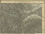
Soboth, Aibl, Radlpass, Großradl in the Deutschlandsberg district
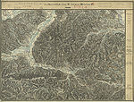
Oberhaag, Schlossberg in the Leibnitz district

Mahrenberg im Drautal in the south of the Radlpass

The Drau valley south of Oberhaag and Schlossberg, 1879

Austrian geological map, around 1930

The border between the Marburg district (yellow) and the Graz district (red-brown) did not always run on the Poßruck, it was moved south several times between 1748 and 1850.

The "Posruck Mountains" in the northwest of what was then Marburg, at the end of the 18th century.


literature
- Siegfried Morawetz: The Styrian-South Slavic border between Hühnerkogel and Kutschenitza. Reproduced in: Ferdinand Tremel (in writing): Festschrift for Otto Lamprecht = Journal of the Historisches Verein für Steiermark, special volume 16 (1968), pp. 19–31.
Web links
- Entry on Poßruck in the Austria Forum (in the AEIOU Austria Lexicon )
Individual evidence
- ↑ R.1 Possruck (Styrian Prealps). Umwelt.steiermark.at → Landscape structure .
- ↑ Thus the labels on the official Slovenian map in several scales.
- ↑ Franz Heritsch : Paleozoic in Possruck. Yearbook of the Federal Geological Institute Volume 83, Vienna 1933. Pages 1–4 ( PDF )
- ^ Franz Angel : Rocks in the area around Leutschach and Arnfels in Styria. Yearbook of the Federal Geological Institute. Volume 83, Vienna 1933. Pages 5-18. ( PDF )
- ↑ Arthur Winkler-Hermaden : The pre-tertiary basement in the Austrian part of the Poßruckgebirge in southern Styria: (Remschniggrücken and Poßruckgebirge northeast of Hl. Geist aP ) Yearbook of the Federal Geological Institute. Volume 83, Vienna 1933. Pages 19-73. PDF file
- ^ Agreement between the Austrian Federal Government and the Federal Executive Council of the Assembly of the Socialist Federal Republic of Yugoslavia on Alpine tourist traffic in the border area (border area - alpine tourist traffic (Yugoslavia)) StF. BGBl. No. 43/1985 (as amended, ris.bka) - further application de facto only in the Republic of Slovenia (BGBl. No. 715/1993).