Podvelka
|
Podvelka Podwölling |
|||
|
|||
| Basic data | |||
|---|---|---|---|
| Country |
|
||
| Historic region | Štajerska | ||
| Statistical region | Koroška | ||
| Coordinates | 46 ° 35 ' N , 15 ° 20' E | ||
| surface | 103.9 km² | ||
| Residents | 2,371 (January 1, 2017) | ||
| Population density | 23 inhabitants per km² | ||
| Telephone code | (+386) 2 | ||
| Post Code | 2365 | ||
| License Plate | SG | ||
| Structure and administration (as of 1999) | |||
| Mayor : | Anton Kovše | ||
| Mailing address | Podvelka 13 2363 Podvelka |
||
| Website | |||
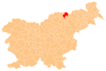
Podvelka ( German : Podwölling ) is a village and municipality in Slovenia . It lies in the historical Spodnja Štajerska ( Lower Styria ) region, but is now part of the statistical region of Koroška ( Lower Carinthia ).
geography
location
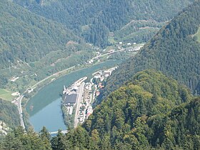
Podvelka is located on the Drava and includes parts of the Kozjak ( Possruck ) to the north and parts of the Pohorje ( Bachern Mountains ) to the south . The valley is very narrow in the area of the municipality, so that there is hardly any space to build larger settlements. Otherwise, the municipality is almost completely shaped by the hill country. The place Podvelka is on the right of the Drava at the road bridge that leads from the valley of the Velka to "Marburger Straße" in the Drautal.
Community structure
The municipality comprises eleven localities. The German exonyms in brackets were mainly used by the German-speaking population until the area was ceded to the Kingdom of Serbs, Croats and Slovenes in 1918 and are largely uncommon today. (Population figures as of January 1, 2017):
|
1 Rdeči Breg and Vurmat only partly belong to the municipality of Podvelka, the municipality of Lovrenc na Pohorju includes another part of Rdeči Breg and Selnica ob Dravi includes a part of Vurmat.
Neighboring communities
| Oberhaag ( A ) | Leutschach ad Weinstrasse ( A ) | |
| Radlje ob Dravi |

|
Selnica ob Dravi |
| Ribnica na Pohorju | Lovrenc na Pohorju |
traffic
Podvelka is located on the Drautalbahn , which runs directly on the right side of the Drava. Two train stations are located directly in the municipality: the centrally located “Podvelka” train station and the “Vuhred elektrarna” train station on the western edge of the municipality, which supplies the small settlement at the hydroelectric power station of the same name. There is also the "Ožbalt" train station, which is located in the municipality of Lovrenc na Pohorju and can only be reached via the dam of the Ožbalt hydroelectric power station. However, only a few regional trains run along the route.
National road 1 "Marburger Strasse" runs on the left side of the Drau. The river can be crossed over two bridges, namely from Brezno to Podvelka and from Vurmat towards Lovrenc na Pohorju.
sons and daughters of the town
- Maks Wraber , b. 1905 in Kappel
Web links
Individual evidence
- ↑ starerazgledniceslovenije − Slovenski kraji-Slo-D. Retrieved February 28, 2010 .
- ^ General state law and government gazette for the Crown Land of Styria. 1850 (supplement Marburg district)
- ↑ Statistical Office of the Republic of Slovenia ( English )


