
Bosruck
| Bosruck | ||
|---|---|---|
 Bosruck northeast side |
||
| height | 1992 m above sea level A. | |
| location | Upper Austria and Styria , Austria | |
| Mountains | Ennstal Alps | |
| Dominance | 4.5 km → Großer Pyhrgas | |
| Notch height | 684 m ↓ Pyhrgasgatterl | |
| Coordinates | 47 ° 37 '22 " N , 14 ° 20' 46" E | |
|
||
| rock | Wetterstein lime | |
| Age of the rock | Triad | |
| First ascent | unknown 1st tourist ascent in 1877 by J. Draxler and J. Friedl |
|
| Normal way | Mountain tour (summit ridge I ) | |


The Bosruck is at 1992 m above sea level. A. Height of the westernmost mountain in the Ennstal Alps on the border between Upper Austria and Styria . It is separated from the main ridge of the Haller walls by the Pyhrgasgatterl and forms its own, ridge-like mountain stock made of limestone.
In front of the Bosruck on the ridge to the west are the peaks Lahnerkogel and Kitzstein , to the east is the Frauenmauer .
ways
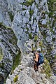
There are three official routes leading to the Bosruck, some of which are rope insured.
- From the Pyhrnpass over the Fuchsalm to the Lahnerkogel. From the Lahnerkogel you move on the ridge and reach the summit of the Bosruck via the Kitzstein. Surefootedness and a head for heights are required to climb the ridge .
- From the Ardningalm over the Kitzstein to the summit.
- From the Arlingsattel over the Wildfrauenhöhle to the Bosruck. This variant is a via ferrata (Wildfrauensteih) with difficulty A / B.
Wildfrauensteig

Wild women cave


tunnel
In the past, the mountain had to be bypassed via the 954 m high Pyhrn Pass (between Bosruck and Warscheneck ), today the two Bosruck tunnels lead through the mountain. Both the Pyhrn Autobahn and the Pyhrnbahn run in separate tunnels from Spital am Pyhrn to Ardning / Liezen . The motorway tunnel is 5400 m long and has two tunnel tubes, one in each direction with two lanes. The second tube was opened in July 2013; After the general refurbishment of the existing system, twin-tube operation began in October 2015.
panorama

literature
- Willi End : Gesäuse mountains. A guide for valleys, huts and mountains (= Alpine Club Guide. Nördliche Kalkalpen series. ). Bergverlag Rudolf Rother, Munich 1988, ISBN 3-7633-1248-X .
- Gerald Radinger: Hiking experience in the Kalkalpen National Park. The most beautiful tours between Enns and Steyr. 2nd, expanded and updated edition. Kral, Berndorf 2012, ISBN 978-3-99024-066-3 .
Web links
- Entry on Bosruck in the Austria Forum (in the AEIOU Austria Lexicon )
- ASFINAG Bosruck Tunnel - overview of the planning work