Kungota
|
Kungota Sankt Kunigund |
|||
|
|||
| Basic data | |||
|---|---|---|---|
| Country |
|
||
| Historic region | Lower Styria / Štajerska | ||
| Statistical region | Podravska (Drau region) | ||
| Coordinates | 46 ° 38 ' N , 15 ° 37' E | ||
| height | 272 m. i. J. | ||
| surface | 49 km² | ||
| Residents | 4,761 (January 1, 2016) | ||
| Population density | 97 inhabitants per km² | ||
| Telephone code | (+386) 02 | ||
| Post Code | 2201 | ||
| License Plate | MB | ||
| Structure and administration | |||
| Mayor : | Tamara Šnofl | ||
| Mailing address | Plintovec 1 2201 Zgornja Kungota |
||
| Website | |||


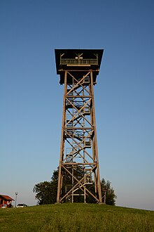
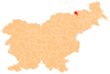
Kungota ( German : Sankt Kunigund ) is a municipality in the Štajerska region in Slovenia .
geography
location
Kungota is about 10 km north of Maribor and borders on Austria to the north and west . The Pesnica ( Pößnitzbach ) flows through the municipality from the west to the southeast. The hill country south of it is the Kozjak , to the north are the Slovenske gorice ( Windische Bühel ). Other important tributaries of the main stream in the municipality are the Plački potok ( Splash stream ) and the Svečinski potok ( Witscheinbach ) on the left and the Radečki potok ( Radourtschbach ) on the right.
Centrally located in the municipality is at 272 m. ü. A. the main town of Zgornja Kungota, which forms a unit with the village of Plintovec.
Community structure
The municipality comprises 19 localities. The German exonyms in brackets date from the middle of the 19th century and are no longer used today. (Population figures as of January 1, 2016):
|
|
1 Rošpoh only partially belongs to the municipality of Kungota, the municipality of Maribor includes another part.
2 The villages of Ciringa, Slatina and Slatinski Dol were divided into two by the Treaty of Saint-Germain on September 10, 1919. The Austrian village of Zieregg today belongs to the municipality of Ehrenhausen , Sulz and Sulztal formed their own municipality until the end of 2014 and are now part of the municipality of Gamlitz .
Neighboring communities
| Ehrenhausen ( Austria ) | Ehrenhausen ( Austria ) | Straß in Steiermark ( Austria ) |
| Gamlitz ( Austria ) |

|
Šentilj |
| Leutschach ( Austria ) | Maribor | Pesnica |
history
The place was first mentioned in a document in 1391. Until October 1918, the area belonged to the Austrian Crown Land, Duchy of Styria . Today's entire community is still young, it was founded in 1994. There is a lot of viticulture.
Web links
Individual evidence
- ^ General state law and government gazette for the Crown Land of Styria. 1850 (supplement Marburg district)
- ↑ SI STAT
- ↑ Statistical Office of the Republic of Slovenia ( English )


