Pesnica
|
Pesnica pri Mariboru Pößnitzhofen |
|||
|
|||
| Basic data | |||
|---|---|---|---|
| Country |
|
||
| Historic region | Lower Styria / Štajerska | ||
| Statistical region | Podravska (Drau region) | ||
| Coordinates | 46 ° 36 ' N , 15 ° 40' E | ||
| surface | 75.8 km² | ||
| Residents | 7,391 (January 1, 2016) | ||
| Population density | 98 inhabitants per km² | ||
| Telephone code | (+386) 2 | ||
| Post Code | 2211 | ||
| License Plate | MB | ||
| Structure and administration | |||
| Mayor : | Venčeslav Senekovič | ||
| Mailing address | Pesnica pri Mariboru 43a 2211 Pesnica p. M. |
||
| Website | |||
Pesnica ( German : Pößnitzhofen ) is a municipality in the Štajerska region in Slovenia .
geography
location
Pesnica is located about six kilometers north of Maribor near the border with Austria in the Slovenske Gorice . The main town Pesnica pri Mariboru (Pößnitzhofen near Marburg an der Drau) is located at 307 m. ü. A. on the Pesnica river ( Pößnitzbach ), which flows through the municipality in the south from west to east. The area is characterized by rolling hills and numerous streams running from north to south.
The most important streams and the resulting valleys are from west to east the Dobrenjski potok ( Dobrenggraben , the A1 motorway runs here ), the Cirknica ( Zirknitzbach , here is the main town), the Gačniški potok ( Gatschniggbach ), the Jareninski potok ( Jahringbach) ), the Vukovski potok ( Wolfsthalbach ), the Jakobski potok ( Jakobsthalbach ) and the Globovnica ( Gogonitzbach ). All of these streams flow into the Pesnica.
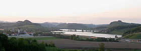
Another important body of water is the Perniško jezero ( Lake Pernica ), an approximately 2 km² artificial lake that is fed by Pesnica, Jareninski potok and Vukovski potok.
According to the 1910 census, the proportion of the German population, which has been declining since the 19th century, was 22.9 percent.
Community structure
The municipality comprises 30 localities. The German place names in brackets have grown historically, but are no longer used today. (Population figures as of January 1, 2016):
|
|
|
Neighboring communities
| Šentilj | ||
| Kungota |

|
Sveti Jurij |
| Maribor | Lenart |
Attractions
The area around Pesnica is a well-known wine region and the Perniško jezero ( Pößnitzhofner See ) is a popular nature area.
The Pesnica viaduct is on the Spielfeld-Straß-Trieste railway line .
traffic
The A1 motorway runs on the western edge of the municipality , via the "Maribor-sever" junction ( Maribor North ) there is a connection to it and thus also to the H2 expressway , which runs through the urban area of Maribor. About 1 km east of this exit is the Dragučova motorway junction, which connects the A1 with the A5 , which the municipality passes through on its southern edge. There is a connection in Pernica.
In addition, the railway line from Šentilj to Zidani Most runs through Pesnica. There is a regional train station right in the main town. The next intercity train station is in Maribor.
Web links
Individual evidence
- ↑ Research on German regional and folklore . J. Engelhorn, Stuttgart 1936, p. 237 ( google.at [accessed on March 7, 2019]).
- ^ General state law and government gazette for the Crown Land of Styria. 1850 (supplement Marburg district)
- ^ Maria Theresia imperatrix Romanorum: Patent dd Grätz, June 28, 1777. concerning the new system of conscriptions with regard to the entire population and livestock . na, 1777 ( google.at [accessed March 7, 2019]).
- ↑ SI STAT
- ↑ Statistical Office of the Republic of Slovenia ( English )
- ↑ See Pesniško jezero


