
Sveta Trojica v Slovenskih goricah
|
Sveta Trojica v Slovenskih goricah Holy Trinity in Windischbüheln |
|||
|
|||
| Basic data | |||
|---|---|---|---|
| Country |
|
||
| Historic region | Lower Styria / Štajerska | ||
| Statistical region | Podravska (Drau region) | ||
| Coordinates | 46 ° 35 ' N , 15 ° 53' E | ||
| height | 287 m. i. J. | ||
| surface | 26 km² | ||
| Residents | 2,071 (January 1, 2017) | ||
| Population density | 80 inhabitants per km² | ||
| Telephone code | (+386) 02 | ||
| Post Code | 2235 | ||
| License Plate | MB | ||
| Structure and administration | |||
| structure | 8 parts of the community | ||
| Mayor : | David Klobasa | ||
| Mailing address | Mariborska cesta 1 2235 Sv. Trojica v Slov. goricah |
||
| Website | |||


Sveta Trojica v Slovenskih goricah ( German : Holy Trinity in Windischbüheln ) is a town and municipality in Slovenia . It is located in the historical Spodnja Štajerska ( Lower Styria ) region and in the statistical region of Podravska .
geography
location

The municipality capital Sveta Trojica v Slovenskih goricah lies at 287 m. ü. A. east of Maribor in the Slovenske gorice ( Windische Büheln ). To the west of Sveta Trojica is the approx. 45 hectare reservoir Trojiško jezero (1950 to 1992: Gradiško jezero). In the south, the A5 motorway runs from Maribor to Murska Sobota through the municipality.
Community structure
The municipality comprises eight localities. The German exonyms in brackets were mainly used by the German-speaking population until the area was ceded to the Kingdom of Serbs, Croats and Slovenes in 1918 and are largely uncommon today. (Population figures as of January 1, 2017):
|
|
Gočova

A village four km south of Sveta Trojica. On the outskirts there are barrows from Roman times with a diameter of seven to ten meters and a height of about 1.5 meters. However, only a few graves have been excavated. To the south of the village there are remains of the Rupnik line (see 6.5 Sights).
Osek
A scattered settlement about six km east of Sveta Trojika. In Osek there are traces of a Roman settlement with a pottery kiln, next to it an ancient Roman quarry and a Roman burial ground with about fifty graves of stonemasons, some of which were archaeologically examined. The partly underground quarry was operated until the Middle Ages. Another quarry was laid out in 1358 and was in operation until 1950. Well-preserved fossils of snails and mussels can still be found in the limestone.
Spodnja Senarska
The small village is three km southeast of Sveta Trojika. Here, too, there are traces of Roman settlement and burial mounds, although some burial sites were partially destroyed by road construction in the previous century.
Spodnje Verjane

The hamlet with the small St. Anna chapel from 1880 is located in the extreme southeast of the community south of the A5 motorway (E653). The chapel was restored in 2008.
Zgornja Senarska
is located two km south of Sveta Trojica north of the motorway exit number 3. There are two small chapels in the village, the small pigeon chapel was built in neo-baroque style in the first half of the 19th century, the lady chapel was built in 1922 by the population as a thank you for the happy homecoming from WW1 erected.
Zgornji Porčič
,_Heilige_Dreifaltigkeit_in_Heilige_Dreifaltigkeit_in_den_Windischen_B%C3%BCheln,_Slowenien;.JPG)
is about two km north of Sveta Trojica on the road to Lenart. Porčič is the Slovenian derivation of the German word for castle ; the Middle High German Purg changed to * Porg in Slovenian , using the diminutive ( small castle ) to * Porgcic on to today's Porčič . The German name Burgstall was first mentioned in written sources in 1338 as Purchstal , 1419 as Purkstal, and 1445 as Purckstall and Purgstal . In 1763 the place Purgstoll , in 1787 for the first time Burgstall . Zgornji porčič literally means "Oberburgstall" to distinguish the settlement from the neighboring "Niederburgstall", Spodnji porčič , and "Altenburgstall", Stari porčič (both located in the municipality of Lenart).
The name Burgstall comes from the Middle High German burcstal and means something like small castle . This small castle was owned by the Styrian Counts von Stubenberger . It was destroyed during the Turkish Wars.
In the village there is a small renovated chapel of the Holy Cross, in Slovenian: Poličeva kapela with a tower in neo-Gothic style, built around 1885.
Zgornje Verjane

is located two km east of Sveta Trojica. In the village there is a neo-baroque Prebevškova chapel with a bell tower from 1870.
Neighboring communities
| Lenart | Benedict | Gornja Radgona |
| Lenart |
.svg)
|
Cerkvenjak |
| Lenart | Trnovska vas | Sveti Andraž v Slovenskih goricah |
Infrastructure
There is a kindergarten, a primary school, an old people's home and a cultural center in the community. The construction of a hotel and a sewage treatment plant has been planned since 2010; construction has not yet started (2016). The households are connected to the internet by fiber optic cables. Sveta Trojika is located at the historical crossroads of the streets from North, Radgona , to South, Ptuj (German: Pettau), and East, Murska Sobota (German: Olsnitz), to West, Maribor. The next big city, Maribor, is 25 km away, the next city, Ptuj, is 21 km away.
history
In 1419 a small castle ( Purgstal , a medieval name for a smaller castle) is mentioned for the first time. In 1631 there are records of a wooden pilgrimage chapel that stood on the hill where the church and monastery now stand; he was called Purgstalberg . According to legend, pilgrims saw three bright lights or stars of great brightness on the hill. According to the story, this miracle led to a first chapel in honor of the Holy Trinity. Count Wolfgang von Stubenberg was captured and imprisoned by agents of the Doge in the 17th century because of a love affair. In the event of his release, he vowed to found a monastery in his homeland. An Augustinian monk helped him to escape and out of gratitude and to fulfill his vows he founded the Holy Trinity Monastery.
With the construction of the church from 1636 to 1643 - the foundation stone was laid on June 15, 1636 - a larger settlement was created at the same time, which was named after the patronage of the church, the Holy Trinity in Windischen Büheln .
In 1663 Augustinians from Radkersburg took over the services and moved into Holy Trinity with the completion of the monastery. The pilgrimages attracted more and more people, so that from 1735 the church and the monastery were partially renovated and enlarged until 1780; especially Count Josip Kazimir Drašković von Trakošćan contributed considerable funds for the construction of the church. In its prime, up to 12,000 pilgrims came to the Holy Trinity every year. Under Emperor Joseph II , pilgrimages were forbidden, the monastery was allowed to stay on the basis of the Edict of Tolerance , as it had served as a school since 1780. In October 1787 the Augustinians applied for the monastery to be closed for financial reasons. At the request of the community, the Franciscan order took over the vacant monastery on June 11, 1853 and continues to run it today.
In 1872 the place was granted market rights. Due to the events of the First and Second World War, there is no longer a German-speaking population in Sveta Trojika. After the communists came to power in Yugoslavia, the name of the municipality was changed to Gradišče , which means castle hill , in 1952 . The basis for the name change was a law from 1948 that provided for the renaming of all religious names for places, squares and streets. In 1953 the village was renamed Gradišče v Slovenskih Goricah . After Slovenian independence, the place got its original name back in 1992, Sveta Trojica v Slovenskih goricah.
In 1955, as part of communist administrative reforms, the municipality of Sveta Trojika was dissolved and added to the municipality of Lenart. On March 1, 2006 Sveta Trojika was again an independent municipality.

Residents
The Windischen Bühel had a mixed settlement of Slovene-speaking and German-speaking population since the Middle Ages. While the Slovene language predominated in the countryside, German was the main language spoken in the cities. Since 1945 there is no longer a German population group in Sveta Trojika.
Population development:
| year | Total population | Slovene-speaking residents | German speaking residents |
|---|---|---|---|
| 1820 | 184 | ||
| 1869 | 324 | ||
| 1880 | 337 | 267 | 67 |
| 1890 | 339 | 249 | 79 |
| 1900 | 348 | 295 | 43 |
| 1910 | 351 | 282 | 66 |
| 1971 | 384 | ||
| 1988 | 447 | ||
| 2010 | 2,103 | ||
| 2015 | 2,066 |
climate
The average annual temperature is 10 ° C. It is coldest in January with an average temperature of −2.5 ° C, and the warmest in July with an average of 21 ° C. Winters are cold and relatively dry, while summers are very warm. The average annual rainfall is 1090 mm per square meter. Since the construction of the reservoir, fog has often formed in November and December. There are an average of 260 sunny days per year.
Attractions
The dominant building and namesake of the place is the pilgrimage church of the Holy Trinity with attached monastery .
Sveta Trojica Church


Franciscan monastery of Sveta Trojika
Archaeological finds from the Roman period
see under 2. Structure for the municipality parts 2.1 Gočova, 2.2 Osek and 2.3 Spodnja Senarska.
Wine museum
The Vinogradniško-poljedelska zbirka is a private museum with exhibits about viticulture in the region and artefacts from the agricultural sector, especially from Lower Styria.
Remnants of the Rupnik line
The Rupnik Line is a defense system that was built in 1938 and was intended to protect Yugoslavia from attack from Germany and Italy. On the road from Gočova to Voličina, several buildings have survived, including former machine gun nests, shelters, trench systems and utilities. There is still an old bunker behind Gočova. The whole system was never used and fell into disrepair after World War II.
Dobrava gozd
The Dobrava Forest is an approximately 102 hectare nature reserve southeast of Sveta Trojika. In the middle of the forest there is a hunting villa from 1974, which was mainly used by communist functionaries. Today the villa is open to the public.
Personalities
- Oroslav Caf, also called Jurij Caf (born April 13, 1814 in Zgornje Verjane, † July 3, 1874 in Ptuj); Linguist, contributor to the first Slovenian grammar and the Slovenian dictionary.
- Dušan Kraigher (born February 8, 1908, died June 15, 1943 in Dobrovlje ) lawyer, deputy political commissioner and communist resistance fighter. Venerated as a national hero in Slovenia.
- Ivo Brnčić or Brnčič (born March 12, 1912 in Sveta Trojica v Slovenskih goricah, † died in May 1943 near Vlasenica, BiH); Author, essayist and literary critic.

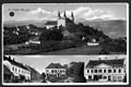
Holy Trinity in the Windischen Büheln, view from the north; Postcard from 1912

Church of Sveta Trojica from the west

Postcard by Sveta Trojica v Slovenskih goricah between 1933 and 1947
Postcard by Sveta Trojica v Slovenskih goricah between 1928 and 1947
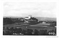
Postcard by Sveta Trojica v Slovenskih goricah between 1928 and 1947

Postcard by Sveta Trojica v Slovenskih goricah between 1928 and 1947

Holy Trinity Church; Holy Trinity in the Windischen Büheln (Sveta Trojica v Slovenskih Goricah); Slovenia, from the north

Trojiski trg (Trinity Square)

Holy Trinity Franciscan Monastery

Sv.Trojica v Slovenskih goricah

.jpg)
.jpg)
.jpg)

;_Slowenien,_von_Norden.JPG)


Web links
- Website of the municipality (Slovenian)
- Map of the municipality of Sveta Trojica v Slovenskih goricah
Individual evidence
- ↑ Special map of the Austro-Hungarian monarchy 1: 75,000 - Radkersburg and Luttenberg 5356. (1914)
- ↑ Population tables of the Statistical Office of the Republic of Slovenia ( Slovene )
- ↑ http://rkd.situla.org ; Ministry of Culture of Slovenia; Immovable Cultural Heritage Register, nos. Ešd 1016, 1050, 1051, 1054 and 28783
- ↑ http://rkd.situla.org ; Ministry of Culture of Slovenia; Immovable Cultural Heritage Register, No. ešd 1016, 1050
- ↑ http://rkd.situla.org ; Ministry of Culture of Slovenia; Immovable Cultural Heritage Register, nos. Ešd 1028, 1029 and 1057
- ↑ http://rkd.situla.org ; Ministry of Culture of Slovenia; Register of Immovable Cultural Heritage, No. ešd 24613
- ↑ http://rkd.situla.org ; Ministry of Culture of Slovenia; Immovable Cultural Heritage Register, nos ešd 22056 and 22057
- ↑ Snoj, Marko: Etimoloski slovar zemljepisnih slovenskih imen (German: Etymological Dictionary of Slovenian Geographical Names), p. 323 Ljubljana: ZRC Modrijan and Založba, 2009.
- ↑ http://rkd.situla.org ; Ministry of Culture of Slovenia; Register of Immovable Cultural Heritage, No. ešd 24 339
- ↑ http://rkd.situla.org ; Ministry of Culture of Slovenia; Register of Immovable Cultural Heritage, No. ešd 3467
- ↑ Jelena Obradović: Nemški geografska imena na področju slovenske Štajerske (German place names in the Slovenian Styria); P. 53; Maribor, 2010
- ↑ Non-profit and exhilarating house calendar for the Austrian Empire ... by Joseph Ritter von Seyfried, Vienna 1841
- ↑ http://rkd.situla.org ; Ministry of Culture of Slovenia; Register of Immovable Cultural Heritage, No. ešd 3464
- ↑ spremembe naselij 1948-95 (German: change of settlement names from 1948 to 1995). 1996. Database. Ljubljana: Geografski inštitut ZRC SAZU, DZS.
- ↑ Premk, F .: Slovenska versko-krščanska terminologija v zemljepisnih imenih in spremembe za čas 1921-1967 / 68th Besedoslovne lastnosti slovenskega jezika: slovenska zemljepisna imena (German: Slovenian religious-Christian terminology in geographical names and the changes for the period 1921-1967 / 68. Lexical features of the Slovenian language: Slovenian geographical names); Pp. 113-132. Ljubljana; Slavistično društvo Slovenije, 2004.
- ↑ Urbanc, Mimi, & Matej Gabrovec: 2005 Krajevna imena: poligon za dokazovanje moči in odraz local identitete (German: Place names 2005: a way to demonstrate the power and reflection of local identity) Geografski vestnik 77 (2) p. 25 -43; 2005
- ^ Gerhard Werner: Language and Volkstum in Lower Styria; Engelmann publishing house, Stuttgart, 1935
- ↑ http://pxweb.stat.si/pxweb/Dialog/varval.asp?ma=05E4030E&ti=&path=../Database/Demographics/05_population/15_Population_structure/20_05E40_Migration_Charac/&lang=1
Benedict · Cerkvenjak · Cirkulane · Destrnik · Dornava · Duplek · Gorišnica · Hajdina · Hoče-Slivnica · Juršinci · Kidričevo · Kungota · Lenart · Lovrenc na Pohorju · Majšperk · Makole · Maribor · Markovci · Miklavž na Dravskem Polju · Oplotnica · Ormož · Pesnica · Podlehnik · Poljčane · Ptuj · Rače-Fram · Ruše · Selnica ob Dravi · Slovenska Bistrica · Središče ob Dravi · Starše · Sveta Ana · Sveta Trojica v Slovenskih goricah · Sveti Andraž v Slovenskih goricah · Sveti Jurij v Slovenskih goricah · Sveti Tomaž · Šentilj · Trnovska vas · Videm · Zavrč · Žetale