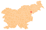
Poljčane
|
Poljčane Pöltschach |
|||
|
|||
| Basic data | |||
|---|---|---|---|
| Country |
|
||
| Historic region | Lower Styria / Štajerska | ||
| Statistical region | Podravska (Drau region) | ||
| Coordinates | 46 ° 19 ′ N , 15 ° 35 ′ E | ||
| surface | 37.5 km² | ||
| Residents | 4432 (1 January 2017) | ||
| Population density | 118 inhabitants per km² | ||
| Post Code | 2319 | ||
| License Plate | MB | ||
| Structure and administration | |||
| Mayor : | Stanislav Kovačič | ||
| Mailing address | Bistriška cesta 65 2319 Poljčane |
||
| Website | |||
Poljčane ( German : Pöltschach ) is a town and municipality in Slovenia . It is located in the historical Spodnja Štajerska ( Lower Styria ) region and in the statistical region of Podravska . The municipality was originally part of Slovenska Bistrica , but has been independent since January 1, 2006.
geography
location
Poljčane lies in the valley of the river Dravinja ( drann ) at the foot of the mountain Boč. In terms of infrastructure, the city is supplied by the nationally important regional roads Maribor – Rogaška Slatina and Celje – Ptuj . In addition, one of the most important railway lines in Slovenia runs through the city, which also has a train station. The next larger cities are Maribor in the north and Celje in the south-west , both around 35 km away.
Community structure
The municipality comprises 18 localities. The German exonyms in brackets were mainly used by the German-speaking population until the area was ceded to the Kingdom of Serbs, Croats and Slovenes in 1918 and are largely uncommon today. (Population figures as of January 1, 2017):
|
|
Neighboring communities
| Slovenske Konjice | Slovenska Bistrica | Macole |
| Slovenske Konjice |

|
Macole |
| Šmarje pri Jelšah | Rogaška Slatina | Macole |
tourism
Poljčane is popular with tourists due to its proximity to Mount Boč. This mountain and its surroundings are used in particular by hikers and mountain bikers .
Economy and Infrastructure
The city has only a few commercial enterprises, mainly in the wood processing, construction and electronics sectors. The area around Poljčane is characterized by agricultural use. Due to the low industrial development of the city, many residents commute to the cities of Maribor and Celje every day. In Poljčane there is a primary school, a health center, a post office and various shops.
Web links
- Official website (Slovenian) ( page no longer available , search in web archives )
- Map of the municipality of Poljčane


