Poessnitz (Drava)
|
Pößnitz / Pesnica Pößnitzbach, Pessnitz [bach] |
||
|
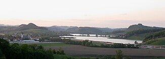
Pößnitztal near Pernitzen |
||
| Data | ||
| Water code | AT : HZB 2-220-232; STM 6799 | |
| location | Windische Bühel ; Styria , Slovenia | |
| Drain over | Drau → Danube → Black Sea | |
| River basin district | Outside | |
| source | in Pößnitz ( Glanz an der Weinstrasse ) 46 ° 40 ′ 9.3 ″ N , 15 ° 30 ′ 58.1 ″ E |
|
| Source height | approx. 430 m above sea level A. | |
| muzzle | at Gorišnica coordinates: 46 ° 24 '1 " N , 16 ° 2' 37" O 46 ° 24 '1 " N , 16 ° 2' 37" O |
|
| Mouth height | approx. 200 m. i. J. | |
| Height difference | approx. 230 m | |
| Bottom slope | approx. 3.3 ‰ | |
| length | 69.7 km | |
| Communities | Leutschach an der Weinstrasse , Kungota , Pesnica , Lenart , Ormož | |
The Pößnitz (also Pößnitzbach , at the beginning of a tributary also called Glanzbach or Pessnitz in Slovenian Pesnica ) is a 69 km long left tributary of the Drau (Drava) in the Windischen Büheln .
The Pößnitz rises in the north of the Pößnitz cadastral community , a place on the Austrian-Slovenian border near Glanz an der Weinstrasse and flows increasingly southwards via Kungota (Sankt Kunigund) , Pesnica (Pößnitzhofen) , Lenart (St. Leonhard) to the confluence with the Drava Ormož (Friedau) on the Pettau field (Ptujsko polje) .
In old documents the brook is also called “Untere Pesnitz” (with a long s “Peſnitz” written).
The eponymous Pößnitzbach zur Saggau (formerly: "upper Pesnitz") also rises near Pößnitz. The fact that two streams on both sides of a valley crossing bear the same name is common with old names on traffic routes in the Alpine region, see Tauernbach . The valley of the two Pößnitz brooks marks the border of the Possruck (Kozjak) to the north-east upstream Windischen Büheln (Slovenske Gorice) .

