Ebenstein
| Ebenstein | ||
|---|---|---|
|
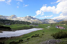
The characteristic summit structure of the Ebenstein from the south |
||
| height | 2123 m above sea level A. | |
| location | Styria , Austria | |
| Mountains | Hochschwab group | |
| Dominance | 5.8 km → Hochwart | |
| Notch height | 348 m ↓ high alpine height | |
| Coordinates | 47 ° 36 '21 " N , 15 ° 1' 42" E | |
|
|
||
| rock | Dachstein Limestone | |
| Age of the rock | Norium - Rhaetium | |
| Normal way | Southwest flank (not difficult ) | |
The Ebenstein ( 2123 m above sea level ) is a mountain in the Hochschwab group in Styria .
Location and name
The Ebenstein is the most striking peak in the western part of the central Hochschwab plateau. The border between the communities Wildalpen and Tragöß-Sankt Katharein runs across it, which also forms the border between the Liezen district and the Bruck-Mürzzuschlag district, newly created in 2013 . The relatively spacious summit region of the Ebenstein breaks off almost all around with steep rock faces; therefore it is separated by deep notches from the Schaufelwand in the west and the Großer Griesstein in the north. Only the southwest flank with the inconspicuous upstream Kleiner Ebenstein ( 1943 m above sea level ) is gentler. The marked normal route leads over them to the summit. The Ebenstein owes its name to the characteristic flattened summit structure, which makes it "recognizable from a great distance".
On clear days, the free-standing summit region of the Ebenstein offers a comprehensive panorama that stretches from the Lower Austrian Pre-Alps over the Ötscher , Gesäuse and Dachstein to the Saualpe in Carinthia . A stone man marks the highest point; the summit cross is about 200 meters further south-east, directly above the cliffs leading to the Sonnschienalm .
Sonnschienalm
To the south and south-east of the Ebenstein extends at about 1500 m above sea level. A. the extensive, slightly undulating plateau of the Sonnschienalm . The region is known for its diverse alpine flora in late spring . In addition to several alpine huts, there is also the Sonnschienhütte of the Voisthaler section of the Austrian Alpine Club , which is an ideal base for tours on the Ebenstein.
Ascents
The only marked path on the Ebenstein leads over its southwest flank. From the Sonnschienhütte you need about 2 hours to the summit via the Sonnschienbründl and just past the Kleiner Ebenstein. The ascent is generally not difficult ; only a short section in the rocky terrain below the summit cross is secured with a wire rope.
Day trips from the valley to the Ebenstein require considerable stamina due to the length of the route and the difference in altitude. Two starting points are particularly suitable:
- from the parking lot in the Jassing northwest of Tragöß via the Russenstraße to the Sonnschienalm, from then on follow the standard ascent. Walking time: 3½ to 4 hours.
- of Winterhöh (south of Wildalpen) over the Kreuzpfäder for sheep neck saddle , continue on the Spitz floors to the marked rise to the top. Walking time: 4½ to 5 hours.
In winter, the Ebenstein from the Jassing is also the destination of extensive ski tours .
literature
- Günter and Luise Auferbauer: Hochschwab , Bergverlag Rudolf Rother , Munich 2009, 5th edition. ISBN 978-3-7633-4189-4
- Adi Mokrejs, Max Ostermayer: Bergwander-Atlas Steiermark , Schall-Verlag, Alland 2009. ISBN 978-3-900533-57-1
Web links
- Brief description of the ski tour from Jassing (on www.styria-alpin.at; PDF; 93 kB)
Remarks
- ↑ In contrast to the Kleiner Ebenstein , the main summit is sometimes also called the Großer Ebenstein .
- ↑ Mokrejs - Ostermayer: Bergwander-Atlas Steiermark , p. 214
- ↑ The serpentine sand road was built by Russian prisoners of war during the First World War .


