Karlhochkogel
| Karlhochkogel | ||
|---|---|---|
|
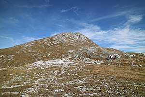
Karlhochkogel from the southwest |
||
| height | 2096 m above sea level A. | |
| location | Styria , Austria | |
| Mountains | Hochschwab Group , Northern Limestone Alps | |
| Dominance | 1.4 km → Hochschwab | |
| Notch height | 198 m ↓ Trawiessattel | |
| Coordinates | 47 ° 36 '26 " N , 15 ° 9' 27" E | |
|
|
||
| rock | Dachstein Limestone | |
| Age of the rock | Upper Triassic | |
The Karlhochkogel is 2096 m above sea level. A. high mountain in the Hochschwab group in the Austrian state of Styria . Due to the flat terrain, it is a popular vantage point immediately southeast of the Hochschwab south face.
Location and surroundings
The Karlhochkogel forms the highest elevation of the Karlalpe, a plateau southeast of the Hochschwab south face, from which it is separated by the Trawiessattel ( 1898 m ). The Festlbeilstein above the Reidelsteinriedel and the Fölzstein ( 1946 m ) are among the most striking features of this massif . Charles Hochkogel even presented mainly from the north as a gentle knoll lawn, but has steep rocky and south and west craggy ground up. To the southeast below the summit lies the eponymous Karl , from which the Karlgraben runs in a south-westerly direction to the Karlschütt and the rear Ilgner valley .
Geology and geomorphology
Like the pole wall on the other side of the Trawiestal, the Karlhochkogel is determined by the Dachstein reef limestone , which is replaced by the banked , lagoon Dachstein limestone towards the hanging wall . In contrast to the pole wall, which is an isolated cover block with a tectonic shape , the horizontal is formed by a dolomite base up to 150 m thick . This could be dated in the Oberkarn using a locally occurring, thin band of Carnic slate and limestone , which separates it from the Wetterstein dolomite.
The reef limestone on the Karlhochkogel is between 200 and 300 m thick. About 50 m of the overlying lagoon have been preserved, but the main mass has long been eroded . On the east side of the Karlhochkogel there is a rich brachiopod fauna as well as a conodont fauna with the species Epigondolella triangularis . The beginning of the reef growth goes back at least to the Lacium . To the east, the reef limestone continues over the Fölzkogel on the Mitteralm, where the platform edge connects to the Aflenz basin .
Ascent
The Karlhochkogel can be climbed more or less easily from several different sides. The simplest variant leads from the Trawiessattel (can be reached from Gasthof Bodenbauer in 3 hours and from the Voisthaler Hütte in 1 hour) via the Hinterwiesen to the summit in about ½ hour. From the Ilgner Valley, the ascent takes 3 to 3½ hours from Bodenbauer via Reidelsteinriedel or, starting at Festlau, through Karlgraben or via Wallmerin. From the south-east, the Karlhochkogel can be climbed in 3½ hours from the Fölzklamm either via the Fölzalm ( 1484 m ) or the Nadelsteinriegel. With the exception of the approaches to Trawiessattel and Fölzalm, all the above-mentioned climbs are unmarked and some are pathless.
The Karlgraben is often used for ski tours in the winter months .
Literature and maps
- Günter and Luise Auferbauer: Hochschwab . Alpenvereinsführer, Bergverlag Rother , 3rd edition, Munich 1990, ISBN 3-7633-1261-7 , p. 206.
- Hochschwab group. Alpine Club Map 1: 50,000, sheet 18, combined print of the official ÖK50 map from the Federal Office for Metrology and Surveying , ISBN 978-3-937530628 .
Web links
Individual evidence
- ↑ a b c Gerhard W. Mandl, Gerhard Bryda & Wolfgang Pavlik: The Dachstein limestone in the Hochkar - Hochschwab area and its position in the development of the calcareous-alpine carbonate platform. In: Arbeitsstagung Geologische Bundesanstalt 2009. Leoben 2009, pp. 70–80. Online PDF , accessed December 24, 2019.
- ↑ Miloš Siblík & Gerhard Bryda: Brachiopods from the Upper Triassic Reef Habitats of the Northern Calcareous Alps (Dachstein Limestone, Hochschwab, Austria). In: Rivista Italiana di Paleontologia e Stratigrafia , Volume 111/3, Vienna 2005, pp. 413–437.
- ↑ Günter and Luise Auferbauer: Hochschwab . Alpenvereinsführer, Bergverlag Rother , 3rd edition, Munich 1990, ISBN 3-7633-1261-7 , p. 206.
- ^ Kurt Schall: Enjoyment ski touring atlas Austria East. 5th, updated edition, Schall-Verlag, Vienna 1999, ISBN 3-900533-22-9 , p. 123.


