Trenchtling
| Trenchtling
Trenching stick
|
|
|---|---|
|
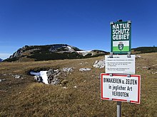
Trenchtlingstock and Leobner Mauer (right) from the west |
|
| Highest peak | High tower ( 2081 m above sea level ) |
| location | Styria , Austria |
| part of | Hochschwab Group , Northern Limestone Alps |
| Coordinates | 47 ° 31 '54 " N , 15 ° 0' 36" E |
| rock | Wetterstein lime |
| Age of the rock | Triad |
| particularities | Almböden nature reserve in the Trenchtling area |
The Trenchtling is a mountain range of the Hochschwab Group in the Austrian state of Styria . The highest point is the 2081 m above sea level. A. high tower .
Location and surroundings
The Trenchtlingstock is located in the southwestern Hochschwab group west of Tragöß-Oberort and extends over a good 5 km in a west-east direction. In addition to the main summit, the Hochturm ( 2081 m ), the Großwand ( 1983 m ) and the Lamingegg ( 1959 m ) form striking elevations . The mountain range is bounded in the west by the Lamingsattel , in the north by Laminggraben and Jassinggraben , in the east by the Tragößer Talboden and in the south by the upper Rötzgraben and the Hiaslegg . While the massif slopes down into the surrounding valleys on three sides, the high mountain character continues to the west. The upholstery and the Griesmauer are a short distance away . In front of the Trenchtling to the west is the 200 meter lower Leoben Wall . Over the saddle between this same peak and the Trenchtlingstock the route passes a 110 kV line of STEWEAG .
Geology and geomorphology
Like many other Hochschwabberge mountains , the Trenchtling is predominantly made of massive Wetterstein limestone. The Triassic rock is in tectonic contact with the underlying Werfen layers . Occurrences of gypsum and Hasel Mountains have already been proven in many places (including on the southern edge of the Meßnerin ) at the contact points . The morphological asymmetry that can be observed in several places on the mountain range is striking . While the Trenchtling shows a pronounced plateau character , especially in the east , steep craggy slopes dominate the central part on the south side and almost vertical rock faces on the north side .
Nature reserve
The eastern part of the Trenchtling plateau is largely under nature protection . The alpine pastures in the Trenchtling area are classified as a nature reserve according to lit. c of the Styrian Nature Conservation Act (NSchG 1976). In particular, the numerous edelweiss and cabbage florets were decisive for the establishment of this protected area.
Ascent
The Trenchtling can be easily crossed on a continuously marked hiking trail. In snow conditions, however, surefootedness is required in certain places. A short but steep, also marked detour leads to the summit cross on the high tower.
Starting points
The ascent time to the high tower is given.
- Upholstered hut : 2½ hours
- Hiaslegg : 3 hours
- Präbichl via Leobner Hütte : 3½ hours
- Parking in Jassinggraben : 3½ hours
- Gsollkehre at Eisenerz : 4 hours
- Vordernberg : 4 hours
Literature and maps
- Günter and Luise Auferbauer: Hochschwab. Bergverlag Rother , Munich 2001, pp. 86-87, ISBN 3-7633-4189-7 .
- Freytag & Berndt Vienna , hiking map 1: 50,000, WK 041, Hochschwab - Veitschalpe - Eisenerz - Bruck ad Mur , ISBN 978-3850847803 .
Web links
Individual evidence
- ↑ G. Bryda: The geology of the map sheet iron ore at a glance . Working Conference of the Federal Geological Institute 2009. [1] (PDF; 16.6 MB), accessed on October 25, 2015
- ↑ NSG-c96 Almböden in the area of the Trenchtling. State of Styria , accessed on October 25, 2015 .


