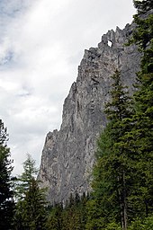
Messnerin
| Messnerin | ||
|---|---|---|
|
Messnerin from the south, at her foot Tragoss Oberort |
||
| height | 1835 m above sea level A. | |
| location | Styria , Austria | |
| Mountains | Hochschwab | |
| Dominance | 4 km → Zinken | |
| Notch height | 620 m ↓ Scheideck | |
| Coordinates | 47 ° 33 '36 " N , 15 ° 5' 8" E | |
|
|
||
| rock | Dachstein limestone , main dolomite and Wetterstein limestone | |
| Age of the rock | Triad | |
The Meßnerin is a mountain in the Hochschwab area in Styria . With its height of 1835 m above sea level. A. forms together with the western Pribitz ( 1579 m above sea level ) the northern end of the valley of the Lamingtal over Tragöß .
Location and surroundings
The Messnerin is from the Hochschwab plateau (Häuselalm, 1526 m above sea A.. ) In the north by the Scheideck saddle ( 1215 m above sea A.. Clearly separated) and falls in the northeast with a steep craggy - and flops edge in the Josertal from. To the west it breaks off with a 700 meter high wall into the gorge, which is the deepest cut to the neighboring Pribitz. The west ridge, already clearly visible from Tragöß, shows a striking rock window, the Messnerinloch.
Routes to the summit
The Meßnerin can be reached from Tragöß via the southern flank or through the Haringgraben and via the Pillsteiner Alm from the east , with little difficulty but with great effort . An unmarked hunting trail leads from the Scheideck saddle in the north to the summit.
Several long climbing routes lead over the west ridge and through the west face.
In front of the brittle north-west ridge stands the pillar-like tower of the Berglandspitze , which has been raised to the rank of an independent summit thanks to several independent climbing routes.
literature
- Peter Rieder: Alpine Club Leader Hochschwab . Bergverlag Rudolf Rother , Munich 1976. ISBN 3-7633-1216-1


