
Kuruzzenschanze

The Kuruzzenschanze (also: Alte Schanze or Türkenschanze ) is a former military fortification line that was built between 1703 and 1711 during the anti-Habsburg uprising under Franz Rákóczi against his troops, the Kuruzzen . The best-preserved section from the Danube at Petronell via Parndorf to Neusiedl am See is around 18 km long; in total, the system (in the never-before-ever final expansion, including branches) would have stretched over around two hundred kilometers.
At the same time, the Linienwall was built in Vienna , which was also supposed to repel attacks by the Turks and Kurucs. On June 11, 1704, an attack by the Kuruzzen could be repulsed on him.
course
The fortification was supposed to protect the border against Hungary with a continuous line of defense. It was part of a line of defense that was supposed to extend from Göding in Moravia to Radkersburg in Southeast Styria and on via Tschakathurn to the area between Mur and Drau (Murinsel) , but was never fully expanded. The original plan was to build the Kuruzzenschanze all the way to Wiener Neustadt. Its course can be seen in maps from designations such as Türkenschanze, Schanzbreiten, Alte Schanze etc., it also forms the eastern boundary of the McArthurGlen Designer Outlet Center in Parndorf.
The course of the ski jump at Zwerndorf bei Weiden an der March and south of Stillfried is documented north of the Danube .
The course of the ski jump north of Markthof in Marchfeld is documented in the recording sheet of the state survey . In 1707 the General-Field Marshal-Lieutenant Count von Löwenburg was sent to this section of the hill to secure and defend the Marchufer.

The east of Styria (compared to northern Burgenland) was less endangered by extensive troop movements because of the hilly terrain. There, the sections of the defense system consisted of some stretches only of entanglement in the river valleys (e.g. in the Raab Valley , Feistritz Valley and Rittschein Valley ) and wooden watchtowers ( Tschartaken ). At the former border between Styria and Hungary in the Lafnitztal valley , chartaks were laid out at intervals of about one to three kilometers, depending on the location of the terrain, in order to relay warning shots and other optical and acoustic messages. Between Radkersburg and Fehring there were 13 Tschartaks on approx. 27 km as the crow flies, between Fehring and Fürstenfeld from the Raab Valley to the Lafnitztal on approx. 15 km as the crow flies there were 18 to 19 Tschartaks. In addition to this first line of defense, there were other positions, such as around the Vorau monastery or on the passes of the Fischbacher Alps ( Pfaffensattel , Alpl or Schanzsattel ). Furthermore, larger places or castles ( Güssing , Friedberg , Hartberg , Fürstenfeld, Radkersburg etc.) were fortified in such a way that they could not be conquered by the Kuruzzen (generally only lightly armed). However, after the defeat of Count Discounta near Mogersdorf against the Kuruzzen, Hohenbrugg Castle, which was well equipped with over 200 firearms , fell into the hands of the Kuruz at short notice on July 4, 1704 and was robbed.
Components
The ski jump consisted of a 4.8 m wide and 2.5 deep ditch from Neusiedl am See to the Danube at Petronell, behind which an approx. 2 m high earth wall (the " parapet ") ran, which was covered with palisades , walled watchtowers and small forts ( Fleschen a few hundred meters apart, plus some simple redoubts and star entrenchments). It was at least partially maintained until the end of the 18th century. Parts of the system can be easily recognized as an earth wall in the Parndorf area . The southern end point of this section was the present-day Tabor ruins, located on the Tabor near Neusiedl am See , which was probably built in the 16th century as a military observation tower against the Turks. The remnants of the Kuruzzenschanze are largely under monument protection (in Parndorf as Alte Schanze , in Neusiedl am See as Neusiedler Schanze , for Fehring , Rohrau , Petronell-Carnuntum , Engelhartstetten , Marchegg and Weiden an der March see the entry at Bad Radkersburg ).

Strategic importance
The Kuruzzenschanze achieved its goals only to a limited extent because it was not possible to occupy it with trained defenders from regular units of the military . Substantial parts of the armed forces necessary for this were already tied up in Hungary in the fight against the Kuruzzen and by the aftermath of the Great Turkish War , but also used in the War of the Spanish Succession . Instead, men of military age were only briefly trained in the manner of a militia . Their resistance to attacks remained low, so that the entrenchments (as far as they were already fully developed) often remained unoccupied because their defenders had fled. This made it possible for the troops of the Kuruzzen to cross larger rivers such as the March in the years after 1703 and to encounter little or no resistance in the area to the west of it. The most intense z. B. in Lower Austria the raids in 1706, where on October 17, 1706 the village of Zistersdorf was burned down. Around 400 deaths were counted in this attack.
After the Hungarian uprising in 1956, the Austrian Armed Forces had a chain of bunkers built parallel to Kuruzzenwall, which became known as "Schleinzer-Wall" after the then Defense Minister Karl Schleinzer . After the fall of the Iron Curtain , this facility was demilitarized, largely dismantled and sold. It is located to the west near the Kuruzzenwall, but has nothing to do with it.
literature
- Walter Blasi, Franz Sauer: The Kuruzzenschanze between Petronell and Neusiedl am See. In: Bundesdenkmalamt (Hrsg.): Find reports from Austria - material booklets. Series A, special issue 19 (FÖMat A / special issue 19), Berger & Söhne, Vienna 2012. ISSN 1993-1271 (incorrect ISSN information, correct ISSN 1993-1255 ). ZDB ID 273065-0 .
- Peter Broucek: The Kuruzzeneinbruch in Lower Austria and in Styria 1703-1709. Military historical publication series Volume 55. Österreichischer Bundesverlag Vienna 1985. ISBN 3-215-06102-3 . ZDB ID 1069189-3
- Franz Ruzicka: Studies on the history of the Kuruzzen incursions in Lower Austria in the years 1703–1709. Dissertation at the University of Vienna, Faculty of Philosophy, July 5, 1977.
- Fritz Posch: Flaming Frontiers. Styria in the Kuruzzenstürme. In: Publications of the Styrian State Archives. Volume 5. Styria, Graz-Vienna-Cologne 1968. 2nd edition Styria Graz 1986. ISBN 3-222-11691-1 . ZDB ID 561078-3 .
Web links
gallery

The Alte Schanze (left) from Petronell to the south
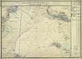
Course of the ski jump in the north of Parndorf
The ski jump between Parndorf and Neusiedl

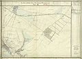
Course of the Kuruzzenschanze north of Markthof (center) on the west bank of the March.


Individual evidence
- ↑ Blasi, Sauer: Kuruzzenschanze. P. 32.
- ↑ Blasi, Sauer: Kuruzzenschanze. P. 27.
- ^ Adelheid Schmeller-Kitt: Dehio manual. The art monuments of Austria. Burgenland. Edited by the Institute for Austrian Art Research of the Federal Monuments Office. 2nd edition 1980. Verlag Anton Schroll Vienna. Pages 230-232. ISBN 3-7031-0493-7 .
- ↑ Posch: Flaming Frontier. 1st edition. Pp. 32-41.
- ↑ Blasi, Sauer: Kuruzzenschanze. Pp. 26-29.
- ^ Adolf Schmidl : travel guide through the Archduchy of Austria with Salzburg, Obersteyermark and Tyrol. Reichard, Güns; Volckmar, Leipzig 1834. pp. 121-122. Schmidl, travel guide, page 122 in the Google book search
- ↑ Josef Scheiger: Hints on some excursions in the quarter under the Wienerwalde and its immediate surroundings. Printing and publishing by M. Chr. Adolph, Vienna 1828. pp. 72–75. Scheiger, Allusions to Excursions, pp. 72–75. in Google Book Search
- ^ Josef Maurer: Castle courtyard. History of the kk pleasure palace and the market at Hof an der March. In: Leaves of the Association for Regional Studies of Lower Austria . New episode XXIII. Born in 1889. Verlag des Verein, printed by Friedrich Jasper, Vienna 1889. p. 215.
- ↑ Blasi, Sauer: Kuruzzenschanze. P. 28.
- ↑ Posch: Flaming Frontier. 1st edition. Pp. 194-203.
- ↑ Posch: Flaming Frontier. 1st edition. Pp. 24-26.
- ↑ Posch: Flaming Frontier. 1st edition. Pp. 56-57.
- ↑ Blasi, Sauer: Kuruzzenschanze. P. 33.
- ↑ Blasi, Sauer: Kuruzzenschanze. Pp. 23-29.
- ^ Willibald Rosner: sheet on the entrenchments between Hohenau and Dürnkrut. In: Lower Austria Archive. NA 01044. Archive publisher. Vienna.
- ↑ Schleinzer Wall
Coordinates: 48 ° 1 ' N , 16 ° 52' E