
Stubai Valley
| Stubai Valley | ||
|---|---|---|
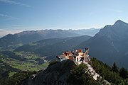
 View from the Elfer out of the valley |
||
| location | Tyrol , Austria | |
| Waters | Ruetz | |
| Mountains | Stubai Alps | |
| Geographical location | 47 ° 9 ' N , 11 ° 21' E | |
|
||
| height | 900 to 1700 m above sea level A. | |
| length | 35 km | |


The Stubai Valley, colloquially known as the Stubai for short , is the largest side valley of the Wipptal and the main valley of the Stubai Alps in the Austrian state of Tyrol . It extends from the glaciated main ridge of the Alps 35 km in a north-easterly direction to the vicinity of the Tyrolean capital Innsbruck . It is a tourist destination , both in summer (e.g. Stubai High Trail ) and in winter ( Stubai Gletscherbahn , Schlick 2000 , Elferlifte and Serlesbahnen ). It is also known for the production of high-quality metal tools from the Stubai brand .
geography

The valley and its mountains
The Stubai Valley, the largest side valley of the Wipptal , is located southwest of Innsbruck . In the front area it is framed on both sides by steep-walled dolomite canes ( Kalkkögel and Serleskamm). From the middle of the valley, the summit heights rise steadily towards the final Alpine ridge up to 3507 m ( Zuckerhütl ). Other well-known peaks in the Stubai Alps that are coveted by mountaineers are the Habicht ( 3277 m ), the Wilde Freiger ( 3418 m ), the Wardrobe ( 3496 m ) and the Ruderhofspitze ( 3473 m ).
The stretched valley line allows a clear view of the glaciated valley end from almost every point. In combination with the symmetry of both valley flanks, the result is a distinctly harmonious landscape that was often praised in ancient literature.
The main river of the valley is the Ruetz , which flows into the Sill below the Brennerstraße at the Stefansbrücke at 680 m above sea level . The largest side valleys are the Schlicker , Pinnis and Oberbergtal . In the catchment area there are almost twenty larger and a number of smaller glaciers, which means that the Ruetz has a distinctive glacial creek character, with flow rates that vary greatly with the day and season.
Communities
There are five municipalities in the Stubai Valley (order inward into the valley):
They form the Stubaital planning association and belong to the Innsbruck-Land district . A total of 13,855 residents live here (as of January 1, 2020), 4811 of them in Neustift and 4462 in Fulpmes.
Traffic situation
Due to the proximity to the Tyrolean capital Innsbruck and the heavily frequented Alpine crossing on the Brenner Pass , the Stubai Valley is very easy to reach. The Brenner autobahn crosses the Wipptal over the Europabrücke . Two kilometers south of this is the Schönberg / Stubai exit, right at the entrance to the Stubai valley. The Brenner federal road also leads past the valley entrance. The Stubaitalstraße also branches off at Schönberg and ends after 31 km at the valley station of the Stubai Glacier Railway at the Mutterbergalm at 1748 m . From the main station in Innsbruck can Telfes and Fulpmes with the 1904 built Stubaitalbahn reach. Each of the five municipalities can be reached with the Stubai bus line operated by Innsbrucker Verkehrsbetriebe .
history
Early history and settlement
The oldest references to the settlement history emerge from place and field names as well as soil finds long before written evidence. Prehistoric ceramic and bronze objects were found on the slopes on both sides of the Ruetz in the foremost valley area. They are dated to the early Bronze Age (approx. 1800 to 1300 BC) and the subsequent Urnfield Age (up to 1000 BC). The Muiggnbichl near Telfes and the Zauberbichl near Schönberg were therefore already settled by the Rhaetians, who were overlaid by migrating Celts in the La Tène period (450 to 250 BC) . The Breonen tribe , named by the Roman poet Horace , was founded in 15 BC. Defeated by the advancing Roman legions. The soldiers were followed by Roman settlers, as indicated by numerous Roman / Latin place and field names up to the alpine region: z. B. Gleins ( collina / collis "hill"), Tschaffinis ( ad cavinas "meadow near the caves"), Tschafalles ( ad cavalles "Rossweide"), Pfurtschell ( forcella / furca , "saddle"), Kampl ( campiglia / campus " Field "), Falbeson ( val busana " Sacktal "), Ranalt ( rovina alta " high mud "), Schangelair ( camp angulairu " angular field "), Kartnall ( cortinale " courtyard "or" fenced in piece of land "), Fagschlung ( fossa longa "long ditch"). At the end of the 6th century AD, the Bavarians began to take over the land and thus, especially in the anterior Stubai Valley, the overlay of the German language. Hermann Ignaz Bidermann reported in 1877 that, according to a legend, the German-speaking population was still unable to communicate with the Romanesque Stubai people in the rear valley area in the High Middle Ages. The name of the valley emerges under the name " inter-Alpes ad Stupeia " ( "inside the mountain in the Stubai Valley") to 993 / 94-1005 for the first time in a traditional note of the Bishopric of Freising on. Later documented names are Stubei, Stubaie or Stubay .
Church and political development

The first church was probably built in early Christian times in Telfes, which for centuries formed the ecclesiastical center of the valley. Church services in Mieders and Fulpmes are documented as early as 1389. In 1515, Emperor Maximilian , who was often out hunting in the back valley, had a chapel built in Neustift. The church buildings currently in the center of the village go back to the Telfer pastor and church builder Franz de Paula Penz and were built around the middle of the 18th century.
A separate court in Stubai under the rule of the Counts of Tyrol is first mentioned in a document in 1326. The seat of the court and thus the political and administrative center of the valley was initially also in Telfes and moved to Mieders around 1690, where it existed - with interruptions - until 1923. Political administration has been with the Innsbruck District Authority since 1869 .
Economic development, history of tourism
The location of Schönberg at the entrance to the Brenner Pass, over which the Romans built a first road, gave this place considerable importance early on. Roman soldiers moved north here, then Germanic tribes south, emperors and popes used this central Alpine crossing. This made it an important trade route from which the neighbors benefited.
In the rest of the valley, as in many other places, an agricultural structure dominated to provide basic supplies for the residents and to pay taxes to church and aristocratic landowners. With one exception: first reports from the 14th century point to the blacksmithing trade in Fulpmes. It is not certain whether the - moderately successful - Stubai mining resulted in the metal trade. It was more likely the other way around. They mainly produced tools, but also tower clocks and later mountain sports equipment. The products were first sold using humpbacks , and from the 17th century onwards on carts. In 1904 the Stubaitalbahn took over their transport.
As a forerunner of tourism, today's most important branch of the economy, the hunting trips of Emperor Maximilian in the 16th, the pilgrimages to Maria Waldrast from the 17th and the summer visitors in Schönberg and Mieders in the 18th and 19th centuries can be enjoyed. Century can be seen. The “Bauernbadln” in Mieders, Medraz and Bärenbad also attracted visitors early on. Mountain tourism developed in the middle of the 19th century and continues to this day. The Alpine Association trained locals to be porters and mountain guides and built huts (the first one was the Dresdner Hut in 1875 ) and paths. Pastor Franz Senn , co-founder of the German Alpine Club , spent the last years of his life in Neustift and is buried in the local cemetery.
Every improvement in traffic access (Brennerstraße, Brennerbahn, Stubaitalbahn, Talstraße and public bus, Brenner motorway) brought more visitors to the valley. The tourist scene shifted from the mountains to the valley, where restaurants and hostels were built. The two world wars caused deep turning points, and a sustained upswing has been recorded since 1945. Ski tourism only became a noticeable factor with the construction of the lift from Fulpmes to Froneben in 1960. After the construction of the Stubai Glacier Railway in 1973, sales in the winter half-year began to overtake summer.
Economy and Infrastructure
tourism
Tourism is the most important industry in the Stubai Valley. It has the most jobs and the strongest sales. One of the strengths of Stubai Tourism is the year-round distribution of the seasons. In addition to the steadily increasing summer tourism since the beginning of alpinism (mid-19th century), winter tourism has grown ever stronger since the construction of the Stubai Glacier Railway (1973) and smaller facilities. In 2010 the winter half-year (Nov. - Apr.) brought 60% of the total of 1.7 million overnight stays and an even higher share of the annual turnover. By far the most tourism-intensive municipality is Neustift. The tourism activities since 2006 from a common tourist Stubai Tirol coordinated and managed. The guests are accommodated in a wide range of establishments, from 5-star hotels, private bed and breakfasts and holiday apartments to huts and campsites. The gastronomic offer is just as diverse.
Winter offer

Due to the altitude and climatic characteristics of the region on the main Alpine ridge, the area is particularly snow-reliable. Winter tourism requires significantly higher investments and maintenance measures. This applies in particular to ski operations with access roads, cable cars and lifts, slopes and supply facilities.
The Stubai Glacier Railways open up the largest glacier ski area in Austria with 700 hectares of ski area. Guests can also choose from the Schlick 2000, Elfer and Serles lifts. The winter offer is complemented by several cross-country ski trails , toboggan runs and winter hiking trails.
Summer offer

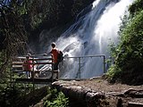
The most important summer attractions are still the mountains and the diverse natural and cultural landscape with glaciers, alpine pastures, meadows, forests, streams and waterfalls. The easily accessible Grawa waterfall is particularly well-known . Three protected areas (Serles-Habicht-Zuckerhütl landscape protection area, Stubai Alps and Kalkkögel quiet areas) were set up in 1983 in order to compensate for the existing developments in spatial planning.
The alpine surroundings of the valley are well developed with eight alpine club huts, numerous snack stations and an extensive network of paths. Several routes are designed as themed hiking trails (e.g. Stubaier Höhenweg , Wilde-Wasser-Weg and Franz-Senn-Weg ). There are viewing platforms at the Schaufelspitze in the glacier ski area ( Top of Tyrol summit platform ) and at the Kreuzjoch above Fulpmes ( StubaiBlick ).
Agriculture and Forestry
Most of the agriculturally used valley floor is between 900 and 1100 m above sea level. Because of the alpine climate, livestock farming dominates with cattle, sheep and goats. The management of the alpine pastures is still very important. Some alpine pastures have been closed, some have recently been reopened. In combination with income from tourism, they seem profitable again. The associated maintenance of the cultural landscape is an essential tourism factor.
Forestry primarily supplies the surrounding area with firewood and construction wood and is of particular importance for protection against natural hazards. There are almost 350 agricultural and forestry businesses in the entire valley. Almost all farmers do agriculture as a sideline, tourism and business supplement their family income. Tourism in particular strengthens the demand for local agricultural products, some of which are sold to consumers directly.
Commercial and industrial
The municipalities of Mieders and Neustift have commercial zones outsourced from the villages, at Fulpmes one can speak of an industrial zone. The Stubai tool industry has a cooperative organization that was founded in 1897 to jointly market the Fulpmer forged products. The product range includes a variety of tools and mountain sports articles. The construction and related trades located in the valley benefit from the numerous tourism companies as clients. The Austrian Federal Railways (ÖBB) operate a run-of-river power plant on the Ruetz near Fulpmes.
Culture & tradition
dialect
The Stubai dialect belongs to the West Tyrolean family. On the outside of the valley, it approaches that of the Wipptal and the Innsbruck area, in Neustift there are similarities with the inner Ziller - or Ötztal , e.g. B. the “umlaut” of long vowels: “hole” for hole, “güet” for gu (a) t. A special feature is the Fulpmer “r”, which is articulated similarly to American English. Vocabulary and syntax have some primeval features. The Fulpmerian is unique in Tyrol. In Medraz (district of Fulpmes ) and in Kampl (district of Neustift im Stubaital ), however, there is a transition between the Fulpmerian dialect and the Neustift dialect. The Stubai dialect is replaced by the Innsbruck dialect in the lower valley ( Schönberg im Stubaital ).
Education
All five municipalities in the valley have elementary schools for six to ten year olds, Neustift even three because of the widely scattered settlements. There and in Fulpmes, the two most populous municipalities, there are also secondary schools, with the one in Neustift being supplemented by a secondary ski school, a special form that is adapted to the special needs of the next generation of skiers. The middle school in Fulpmes also accepts the children from Schönberg, Mieders and Telfes. Fulpmes also has a higher technical college for metalworking, which leads to the Matura .

Music and riflemen, costume
Music bands are part of the basic cultural equipment of a Tyrolean village, and this also applies in the Stubai. Like the rifle companies, they appear in uniform valley dress. This can be traced back further than anywhere else in Tyrol, namely to the vicinity of the Tyrolean wars of freedom in the early 19th century. Church and other choirs as well as some dance bands also contribute to the musical culture. The musical education has a solid basis thanks to the regional music schools.
Performing and visual arts, museums
All communities have village stages, including the Stubai Farmers' Theater in Fulpmes, which has the longest and richest tradition since 1903. A number of visual artists live and work in the valley, including the painter Herbert Danler (Telfes), the wood sculptor Hansjörg Ranalter (Neustift) and the metal artist Johannes Maria Pittl (Fulpmes) stand out. Nativity carving is of high quality ; Fulpmes can be described as a "crib village" and takes this into account with a crib museum. There is also a blacksmith's museum, and in Neustift / Kampl there is a local museum with old farm, handicraft and tourist inventory.
Personalities
- Michael Pfurtscheller , merchant, innkeeper and comrade-in-arms of Andreas Hofer
- Franz Senn , pastor and tourism pioneer
Artist
- Franz de Paula Penz , pastor and church builder
- Ludwig Penz , sculptor
- Clemens Holzmeister , architect
- Herbert Danler , academic painter
athlete
- Vinzenz Hörtnagl , weightlifter
- Markus Prock , artificial track tobogganist
- Ingo Appelt , bobsledder
- Andreas Kofler , ski jumper
- Gregor Schlierenzauer , ski jumper, ski flyer
- Andreas Orgler , alpinist, architect, hang-glider
- Stefan Denifl , racing cyclist
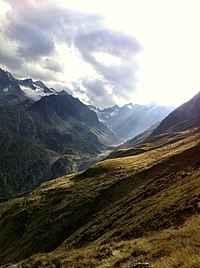
Impressions
Panoramaweg StubaiBlick in the Schlick2000
WildeWasserWeg

Schlicker See

View from Hohen Burgstall towards Schlick.
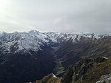
View from the Hohen Burgstall to the Oberbergtal

View over the entire Stubai Valley

View from the Serles to the Kesselspitze


View from Ampferstein towards Kalkkögel
View towards the Franz Senn Hut


literature
- Ludwig Barth , Leopold Pfaundler : The Stubai Mountain Group , Innsbruck 1865.
- Society of friends of the Stubeithales: Stubei: Thal und Gebirg, Land und Menschen , Leipzig 1891. This comprehensive reference work with 774 pages contains a detailed description of the valley, the settlements and mountains, a “history of tourism” and informative articles on vegetation and geology , Wildlife, agriculture and forestry, history, administration, social affairs and culture, church and art, industry and trade.
- Paul R. Greußing: Through Stubai, A guide into the Stubai including mountain guide tariff and directory , Innsbruck, several editions from 1905.
- Heinrich and Walter Klier : Alpine Club Guide Stubai Alps , Munich 1988.
- Heinrich and Walter Klier: Stubai beautiful valley , Innsbruck 2000.
- Otto Kostenzer: Stubai , Innsbruck-Vienna-Munich 1975.
- Hanspaul Menara : Stubai Alps. The mountains between Brenner and Timmelsjoch , Bozen 1981.
- Alois Neuner, Hermann Prechtl: In's Stubai - Guide through the Stubaital and its glacier world , Innsbruck 1929.
- Hugo Meinhard Schiechtl: Stubaier Wanderbuch , Innsbruck-Vienna 1985.
- Karlheinz Töchterle: Stubai. A Talbuch , 2nd edition, Innsbruck-Vienna-Munich 1991.
- Heinz Zak : Stubai Alps , Munich 2003.
Web links
Individual evidence
- ↑ Statistics Austria - Population at the beginning of 2002–2020 by municipalities (area status 01/01/2020)
- ↑ Ludwig Steub (1854): On Rhaetian Ethnology . Stuttgart ( online
- ↑ Even today, cortinal is used in Spanish to refer to a communally used, mostly fenced-in piece of land near the village. In the Dolomite Ladin language , the meaning of cemetery has changed.)
- ^ Franz Prix (1888): Linguistic studies on Columella . Baden, p. 18 ( online )
- ^ Hermann Ignaz Bidermann: The novels and their distribution in Austria . Graz 1877, p. 108 ( online )
- ↑ Martin Bitschnau , Hannes Obermair : Tiroler Urkundenbuch, II. Department: The documents on the history of the Inn, Eisack and Pustertal valleys. Vol. 1: Up to the year 1140 . Universitätsverlag Wagner, Innsbruck 2009, ISBN 978-3-7030-0469-8 , p. 135-137 No. 170 .
- ↑ Christian Schneller: An onomatological walk through North and Central Tyrol. In: Publications of the Tiroler Landesmuseum Ferdinandeum 3/50 (1906), pp. 115–135 ( PDF file ; 1.1 MB)
- ↑ Georg Mutschlechner: Stubai around 1800. In: Publications of the Tiroler Landesmuseum Ferdinandeum 72 (1992), pp. 5–20 ( PDF; 12 MB )
- ^ Stubai Tirol Tourist Office
- ↑ Stubai Glacier Railways
- ↑ Schlick 2000
- ↑ 911
- ↑ Serles lifts
- ↑ WildeWasserWeg