Pinnisbach
| Pinnisbach | ||
|
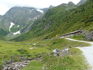
Karalm with Pinnisbach in the upper Pinnistal |
||
| Data | ||
| Water code | AT : 2-8-153-50-44 | |
| location |
Stubai Alps Tyrol Austria |
|
| River system | Danube | |
| Drain over | Ruetz → Sill → Inn → Danube → Black Sea | |
| source | below the hawk 47 ° 2 ′ 55 ″ N , 11 ° 18 ′ 14 ″ E |
|
| Source height | 2170 m above sea level A. | |
| muzzle | In Neder in the Ruetz coordinates: 47 ° 7 ′ 11 ″ N , 11 ° 19 ′ 24 ″ E 47 ° 7 ′ 11 ″ N , 11 ° 19 ′ 24 ″ E |
|
| Mouth height | 968 m above sea level A. | |
| Height difference | 1202 m | |
| Bottom slope | 12% | |
| length | 9.7 km | |
| Catchment area | 22.4 km² | |
The Pinnisbach flows through the small, eponymous side valley of the Stubai Valley and is one of the larger tributaries of the Ruetz . It rises below the hawk and flows in a north-easterly direction through the Pinnistal. It joins the Ruetz at the Ruetzbrücke in the Neder district of the Neustift community in the Stubaital . The stream has several tributaries and a length of almost 10 km. A large part of it is fed from the Pinnisferner on the northeast slope of the Habicht.
The stream has water quality class I throughout and is classified as a raging mountain stream.
In the Pinnistal are the four (former) alpine pastures Herzebenalm, Issenangeralm ( 1366 m above sea level ), Pinnisalm ( 1560 m above sea level ) and Karalm ( 1747 m above sea level ); everywhere there are gastronomic offers and z. T. also a simple overnight option. You can take a (line) taxi to the Karalm.


