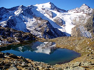
Wild freiger
| Wild freiger | ||
|---|---|---|
|
View from Grünau to the summit massif |
||
| height | 3418 m above sea level A. | |
| location | Tyrol , Austria and South Tyrol , Italy | |
| Mountains | Stubai Alps | |
| Dominance | 2 km → Wilder Pfaff | |
| Notch height | 282 m ↓ Pfaffennieder | |
| Coordinates | 46 ° 58 '14 " N , 11 ° 11' 23" E | |
|
|
||
| First ascent | 1865 by Franz Leis and two other alpine farmers | |
| Normal way | Glacier tour from the northeast or high tour from the southeast | |
|
Wilder Freiger from the northeast, dated P. 3222 |
||
The Wild Freiger ( Italian Cima Libera ) is a 3418 m above sea level. A. high mountain in the Stubai Alps in Tyrol on the border between the Austrian North Tyrol and the Italian South Tyrol . The mountain is located in the main Alpine ridge between Freilerscharte and Pfaffennieder , the latter notch separates the summit from the nearby Wilder Pfaff and the Zuckerhütl .
Climbs
The mountain offers numerous climbs, both from the north from the Stubai Valley and from the south, from the Italian side.
The most popular ascent from the north leads from the Nürnberger Hütte ( 2278 m ) first to the south, under the Urfallspitze and southwest up to the Seescharte , where the ascent from the Sulzenauhütte joins. Further to the southwest it goes below the Gamsspitze through to an ice field. The earlier ascent now led north of the ice field to the ridge. Due to the risk of falling rocks, however, at least in summer, we now descend a little to get east below the ice field to a ridge on which the ascent to the ridge takes place. Via the ridge you reach P.3222, where you enter the glacier and cross under the signal summit to reach the southeast ridge and over it to the summit.
In contrast to the north ascent, the ascent from the south is possible without ice equipment, even if the dead glacier tongue southeast of the Becher has to be crossed on the ascent path from the Ridnaun valley via the Teplitzer hut to the Becherhaus ( 3195 m ). The ascent from the Becherhaus takes place over the south ridge of the signal summit with a meteorological station and further north-west over the connecting ridge to the main summit. The Wild Freiger can be reached in just under an hour from the Becherhaus.
There are other ascent possibilities, including from the Müller or Sulzenauhütte , but these are less frequent and are mostly more difficult.
Literature and map
- Edwin Schmitt, Wolfgang Pusch: High alpine tours in the Eastern Alps. Bergverlag Rudolf Rother , Munich 2008, ISBN 978-3-7633-3010-2 .
- Heinrich and Walter Klier : Alpine Club Guide Stubai Alps. Bergverlag Rudolf Rother, Munich 2006, ISBN 3-7633-1271-4 .
- Richard Goedeke : 3000 meters in the northern Alps. Bruckmann, Munich 2004, ISBN 3-7654-3930-4 .
- Hanspaul Menara : The most beautiful 3000m peaks in South Tyrol. 70 worthwhile alpine tours. Athesia, Bozen 2014, ISBN 978-88-8266-911-9
- Alpine Club Card. Sheet 31/1, 1: 25,000, Stubai Alps; Hochstubai. ISBN 3-928777-08-4 .
Web links
Individual evidence
- ↑ Clem Clements, Jonathan de Ferranti, Eberhard Jurgalski , Mark Trengove: The 3000 m SUMMITS of AUSTRIA - 242 peaks with at least 150 m of prominence , October 2011, p. 11.
- ↑ Federal Office for Metrology and Surveying Austria: Wilder Freiger on the Austrian Map online (Austrian map 1: 50,000) .


