
Serles
| Serles | ||
|---|---|---|
 Serles |
||
| height | 2717 m above sea level A. | |
| location | Tyrol , Austria | |
| Mountains | Stubai Alps | |
| Dominance | 2.8 km → Kesselspitze | |
| Notch height | 333 m ↓ Serlesjöchl | |
| Coordinates | 47 ° 7 '24 " N , 11 ° 22' 54" E | |
|
||
| rock | Lime marble , including main dolomite | |
| Age of the rock | Upper Triassic | |
| First ascent | around 1579 by the presumed chamois hunter H. G. Ernstinger | |
| Normal way | Hike from Maria Waldrast | |

The Serles , also called Waldrastspitze in the Alpine Club Guide , is a mountain between the Stubaital and Wipptal in Tyrol / Austria with a height of 2,717 m. Due to its three-tier construction and its dominant view from Innsbruck , the mountain is also called the " high altar of Tyrol ". The name "King Serles", which is also common, goes back to an old folk legend. According to legend, the main peak of the Serles is an evil king petrified as a punishment, the two secondary peaks are his also petrified sons, according to other versions also other family members.
etymology
For the meaning and origin of the name "Serles", the following is a text on a notice board on the Serlesjöchl:
" The sun rises and falls over the Serles twice in winter in Mieders . It is therefore not surprising that the summit takes its name from the Ladin name for sun 'Suredl'. Because 'Suredl' also means 'sun stone', the entire summit became Serleskamm, which stretches from the Serles summit over approx. 10 kilometers to the Pinnisjoch, formerly also called Sonnenstein. The name Sonnenstein has remained until today, but only the mountain in front of the Serles summit. "
accessibility
The Serles is almost exclusively about 500 meters to the southwest located 2,384 m high Serlesjöchl climbed the
- from Matrei am Brenner via Maria Waldrast
- from Mieders ascent with the Serlesbahn, hike via Maria Waldrast
- from Kampl, a district of Neustift im Stubaital , or from Medraz, a district of Fulpmes via the Alpengasthaus Wildeben
is attainable. From there a partially insured trail leads to the summit ( T3 ). All other climbs through the north face and over the secondary peaks are serious alpine climbing routes up to level V.
photos

Serles, in the foreground the Europe Bridge , in the background the Habicht
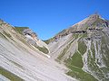
View of the Serlesjöchl and the summit structure


Web links
- Ascent from the Stubaital on meinstubaital.at
swell
- ^ Federal Geological Institute : Geological Map of the Republic of Austria 1: 50,000. 148 burners. Vienna 2009.
- ↑ a b Heinrich and Walter Klier : Alpine Club Guide Stubai Alps . Bergverlag Rudolf Rother, Munich 1988, ISBN 3-7633-1252-8
- ↑ Serlessage on Tibs.at, Tyrolean education server. ( Memento of the original from September 27, 2007 in the Internet Archive ) Info: The archive link was inserted automatically and has not yet been checked. Please check the original and archive link according to the instructions and then remove this notice. Accessed: January 5, 2008
- ↑ Riese Serles on haben.at. Accessed: January 5, 2008