Western Rhaetian Alps
| Western Rhaetian Alps | |
|---|---|
|
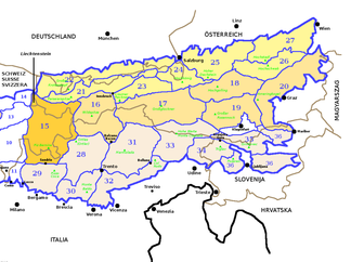
The Western Rhaetian Alps (section 15) according to SOIUSA within the Eastern Alps |
|
|
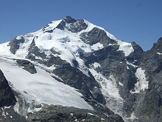
Piz Bernina , the highest peak in the Western Rhaetian Alps |
|
| Highest peak | Piz Bernina ( 4049 m above sea level ) |
| location |
Vorarlberg and Tyrol ( Austria ), Liechtenstein , Graubünden ( Switzerland ), the provinces of South Tyrol and Sondrio ( Italy ) |
| part of | Central Eastern Alps |
| Classification according to | SOIUSA : 15 |
| Coordinates , ( CH ) | 46 ° 40 ' N , 9 ° 50' O ( 783 236 / 171178 ) |
The Western Rhaetian Alps are a section of the Central Eastern Alps in the international unified orographic division of the Alps (SOIUSA) according to Sergio Marazzi .
classification
| Classification according to SOIUSA | ||
|---|---|---|
| part | II | Eastern Alps |
| sector | II / A | Central Eastern Alps |
| section | 15th | Western Rhaetian Alps |
The Western Rhaetian Alps have no direct equivalent in other classification systems. The Alpine Club division (AVE) divides the Eastern Alps into four instead of three areas, the Western Rhaetian Alps according to SOIUSA include the western part of the Central Eastern Alps , the northern part of the Western Eastern Alps and a small part of the Southern Eastern Alps according to AVE. The Partizione delle Alpi only knows the section of the entire Rhaetian Alps , which according to SOIUSA is divided into a western, an eastern and a southern section.
Boundary
The border of the Western Rhaetian Alps runs clockwise along the line Ill - Alfenz - Arlbergpass - Rosanna - Sanna - Inn - Reschenpass - Etsch - Trafoier Bach - Stilfser Joch - Braulio - Adda - Mera - Liro - Splügenpass - Hinterrhein - Alpenrhein . The Arlberg Pass forms the connection to the North Tyrolean Limestone Alps , the Reschen Pass to the Eastern Rhaetian Alps , the Stilfser Joch to the Southern Rhaetian Alps and the Splügen Pass to the Lepontine Alps .
Breakdown
The Western Rhaetian Alps are divided into two sectors and eight subsections.
| sector | Subsection | Correspondence in the AVE | Highest peak | height | |||
|---|---|---|---|---|---|---|---|
| A. | Southwest Rhaetian Alps (Southeast Graubünden Alps) |
I. |
Platta Alps (Avers Mountains) (Oberhalbsteiner Alps) |
64 | Platta group | Piz Platta | 3392 m above sea level M. |
| II | Albula Alps | 65 | Albula Alps | Piz Kesch | 3418 m above sea level M. | ||
| III | Bernina Alps | 66 | Bernina group | Piz Bernina | 4049 m above sea level M. | ||
| IV | Livigno Alps | 67 | Livigno Alps | Cima de 'Piazzi | 3439 m slm | ||
| V |
Münstertal Alps (Western Val Venosta Alps) |
29 | about Sesvenna group | Piz Sesvenna | 3204 m above sea level M. | ||
| B. | Northwest Rhaetian Alps (Northeast Graubünden Alps) |
VI | Silvretta - Samnaun - Ferwall -Alps | 26th | Silvretta | Piz Linard | 3411 m above sea level M. |
| 27 | Samnaun group | ||||||
| 28 | Verwall | ||||||
| VII |
Plessur Mountains (Plessur Alps) |
63 | Plessur Alps | Aroser Rothorn | 2980 m above sea level M. | ||
| VIII | Rätikon | 25th | Rätikon | Schesaplana | 2964 m above sea level M. | ||
literature
- Sergio Marazzi : Atlante orografico delle Alpi. SOIUSA - Suddivisione orografica internazionale unificata del Sistema Alpino . 1st edition. Priuli & Verlucca, Scarmagno 2005, ISBN 88-8068-273-3 (Italian, abstract [PDF; 1.6 MB ; accessed on December 26, 2016]).


