
Archbach
| Archbach | ||
 The course of the Archbach |
||
| Data | ||
| Water code | AT : 2-4-95 | |
| location | Tyrol , Austria | |
| River system | Danube | |
| Drain over | Lech → Danube → Black Sea | |
| origin |
Plansee 47 ° 28 ′ 46 ″ N , 10 ° 46 ′ 22 ″ E |
|
| Source height | 976 m above sea level A. | |
| muzzle | near Pflach in the Lech coordinates: 47 ° 30 '47 " N , 10 ° 42' 44" E 47 ° 30 '47 " N , 10 ° 42' 44" E |
|
| Mouth height | 832 m above sea level A. | |
| Height difference | 144 m | |
| Bottom slope | 21 ‰ | |
| length | 7 km | |
| Catchment area | 144.61 km² | |
The Archbach , also called Planseeache , is a right-hand, 7 km long tributary of the Lech in Tyrol , Austria .
It rises from the Plansee in Breitenwang as its only drain, hence the name Planseeache . In its initially steep valley, it flows northwest over the Stuibenfalls to Reutte and to Pflach , where it flows into the Lech .
The Archbach has water quality class II.

Plansee from the southeast, in the middle the outflow through the Kleiner Plansee or the Archbach in the direction of the Lechtal
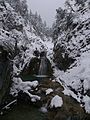
The Archbach in the lower area of the Stuiben Falls
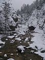
The Archbach shortly before leaving the Stuibenfalls towards Mühl


Individual evidence
- ↑ a b TIRIS - Tyrolean regional planning and information system
- ↑ Directory of stream and river areas in Bavaria - Lech river area, page 1 of the Bavarian State Office for the Environment, as of 2016 (PDF; 1.8 MB)
- ↑ Federal Ministry of Agriculture, Forestry, Environment and Water Management (ed.): Saprobiological water quality of the flowing waters of Austria. As of 2005. ( PDF; 1 MB ( Memento of the original from December 22, 2015 in the Internet Archive ) Info: The archive link has been inserted automatically and has not yet been checked. Please check the original and archive link according to the instructions and then remove this note. )