
Schleching
| coat of arms | Germany map | |
|---|---|---|

|
Coordinates: 47 ° 43 ' N , 12 ° 24' E |
|
| Basic data | ||
| State : | Bavaria | |
| Administrative region : | Upper Bavaria | |
| County : | Traunstein | |
| Height : | 569 m above sea level NHN | |
| Area : | 45.16 km 2 | |
| Residents: | 1856 (Dec. 31, 2019) | |
| Population density : | 41 inhabitants per km 2 | |
| Postal code : | 83259 | |
| Area code : | 08649 | |
| License plate : | TS, LF | |
| Community key : | 09 1 89 141 | |
| Community structure: | 12 districts | |
| Address of the municipal administration: |
Kirchplatz 1 83259 Schleching |
|
| Website : | ||
| Mayor : | Josef Loferer ( CSU ) | |
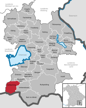
| Location of the community Schleching in the district of Traunstein | ||
  |
||

Schleching is a municipality in the Upper Bavarian district of Traunstein on the border with Tyrol .
geography

location
Schleching is located in the Chiemgau south of the Chiemsee . It is located in the middle of the wide Achental, surrounded by mountains. Above all, the Hochplatte , the Hochgern and the Blumenberg of the Achental with its nature reserve, the Geigelstein, should be mentioned .
Community structure
Schleching has twelve districts:
Neighboring communities
Neighboring communities are Grassau and Marquartstein in the north, Unterwössen in the east , Aschau in the west and Kössen (Austria) in the south .
history
The town of Slehingin was mentioned for the first time in deeds of donation from the Baumburg monasteries near Altenmarkt and St. Peter in Salzburg, as well as by the Salzburg cathedral chapter from 1122 to 1147 . As unfree farmers, most of them were fundamental subjects of the Bavarian duke and the Salzburg archbishop with his cathedral chapter until the beginning of the 19th century. The Bavarian duke has always been the sovereign ruler.
In terms of church, Schleching became a curate in 1709 and an independent parish in 1921.
On April 1, 1938, parts of the area were ceded to the new municipality of Marquartstein .
Schleching has been part of the international alpine association initiative Bergsteigerdörfer since 2017 .
Population development
Between 1988 and 2018 the municipality grew from 1,522 to 1,821 by 299 inhabitants or 19.7%.
politics
mayor
Josef Loferer ( CSU ) has been mayor since May 1, 2008; he was elected on March 15, 2020 with 74.75% of the vote for a further six years.
coat of arms
The coat of arms was awarded on October 21, 1926 by the State Ministry of the Interior.
Blazon : "In gold, the half-length figure of St. Bishop Remigius in a blue cope with the golden pedum in the left and an oil vessel over which a white dove flies to him in the right."
Saint Remigius is the patron saint of the parish church and the village of Schleching. The saint was chosen as a coat of arms to commemorate the old age of the place and the Christianization of the Bavarian region by Frankish missionaries at the turn of the 8th to 9th century. Another aspect was to create a meaningful reference point for local history lessons through the saint figure. In the time of National Socialism , saints were not welcome in local coats of arms. The Schlechinger coat of arms was also objected to in 1938 and should be changed. However, the project was not carried out.
flag
The flag in blue and gold (vertical) with the included coat of arms on a white background in the horizontal upper quarter was approved on August 16, 1954.
Culture and sights
Museums
Hammer forge in the Raiten district from 1697
Buildings
- Parish Church of St. Remigius by Abraham Millauer , built 1735–1758
- Cemetery with numerous wrought iron grave crosses
- Pilgrimage church Maria zu den seven Linden in the district Raiten
- Pilgrimage church of St. Servatius auf dem Streichen, also known as the Streichenkirche , with frescoes from the 15th and 16th centuries as well as carved altars from the 16th century and a valuable box altar from around 1410

Parish Church of St. Remigius

Pilgrimage church Maria zu den seven Linden in the district Raiten

Streichenkirche near Schleching

Geigelstein, seen from the Streichenkapelle


Soil monuments
traffic
The closest motorway is the BAB 8 between Salzburg (Austria) and Munich . You can reach Schleching via the exits Bernau (from the west, Munich) or Grabenstätt (from the east, Salzburg). The nearest train stations are in Bernau am Chiemsee, Übersee am Chiemsee and Prien am Chiemsee on the main Munich-Salzburg route. From there you can take the following bus connections to Schleching:
- from Übersee station with the RVO bus line 9509 to Schleching or
- From Prien train station, take the RVO bus line 9505 towards Reit im Winkl , change in Marquartstein, towards Schleching.
The nearest airports are Munich (approx. 100 km) and Salzburg (approx. 65 km), both with rail connections.
Web links
- Official website of the community Schleching
- Mountaineering village Schleching
- Entry on Schleching's coat of arms in the database of the House of Bavarian History
Individual evidence
- ↑ "Data 2" sheet, Statistical Report A1200C 202041 Population of the municipalities, districts and administrative districts 1st quarter 2020 (population based on the 2011 census) ( help ).
- ↑ http://www.bayerische-landesbibliothek-online.de/orte/ortssuche_action.html ? Anzeige=voll&modus=automat&tempus=+20111109/165501&attr=OBJ&val= 567
- ^ Wilhelm Volkert (ed.): Handbook of Bavarian offices, communities and courts 1799–1980 . CH Beck, Munich 1983, ISBN 3-406-09669-7 , p. 581 .
- ↑ Matthias Köpf & Christian Sebald: These are the two most beautiful mountaineering villages in Bavaria. Süddeutsche Zeitung , July 22, 2017, accessed on November 8, 2018 .
- ↑ Decision of August 16, 1954 No. IB 1 - 3000 - 29 Sch / 2
- ↑ Figure: http://www.kommunalflaggen.eu/index.php?title=Datei:Schleching1.jpg

Altenmarkt an der Alz | Mountains | Chieming | Engelsberg | Fridolfing | Grabenstätt | Grassau | Inzell | Kienberg | Kirchanschöring | Marquartstein | Nussdorf | Obing | Palling | Petting | Pittenhart | Reit im Winkl | Ruhpolding | Schleching | Schnaitsee | Seeon-Seebruck | Siegsdorf | Staudach-Egerndach | Surberg | Tacherting | Taching at the lake | Tittmoning | Traunreut | Traunstein | Trostberg | Overseas | Unterwössen | Vachendorf | Waging am See | Wonneberg
Unregulated areas: Chiemsee | Waginger See