
Underweave
| coat of arms | Germany map | |
|---|---|---|

|
Coordinates: 47 ° 44 ' N , 12 ° 27' E |
|
| Basic data | ||
| State : | Bavaria | |
| Administrative region : | Upper Bavaria | |
| County : | Traunstein | |
| Height : | 555 m above sea level NHN | |
| Area : | 41.28 km 2 | |
| Residents: | 3577 (Dec. 31, 2019) | |
| Population density : | 87 inhabitants per km 2 | |
| Postcodes : | 83246, 83250 | |
| Primaries : | 08641, 08640 | |
| License plate : | TS, LF | |
| Community key : | 09 1 89 160 | |
| Community structure: | 31 districts | |
| Address of the municipal administration: |
Rathausplatz 1 83246 Unterwössen |
|
| Website : | ||
| Mayor : | Ludwig Entfellner ( CSU ) | |
| Location of the community Unterwössen in the district of Traunstein | ||
  |
||

Unterwössen is a municipality in the Upper Bavarian district of Traunstein with the districts Hinterwössen, Oberwössen and Unterwössen. The community is located on the federal highway 305 between Marquartstein and Reit im Winkl .
geography


Geographical location
The district of Unterwössen is still in the Achental , while the two districts of Hinterwössen and Oberwössen are located in a closed valley basin, which is separated from the Achental by a small mountain ridge. The Wössen Bach, the Kaltenbach and the Tiroler Achen flow through Unterwössen.
Community structure
There are 31 districts:
|
Neighboring communities
Neighboring communities are Marquartstein, Reit im Winkl , Ruhpolding , Schleching , Staudach-Egerndach and the Austrian Kössen .
history
Until the church is planted
Settlement of the area goes back to Celtic and Roman origins. The pottery shards that were found near the Rettenburg on a ridge between Hinterwössen and Kruchenhausen date to around the year 900, which suggests an already existing settlement in Oberwössen or Unterwössen.
Unterwössen was first mentioned in a document in 1120. The name Oberwössen was first mentioned in the tax register of 1420. In the Spanish (1701–1714) and Austrian (1740–1748) War of Succession, the local population suffered great damage due to the location near the border. Oberwössen and Unterwössen in today's Upper Bavaria district belonged to the Burghausen Rent Office and the Marquartstein Regional Court of the Electorate of Bavaria . In the course of the administrative reforms in Bavaria , the municipal edict of 1818 created the municipalities of Oberwössen and Unterwössen.
19th and 20th centuries
From 1810 to 1850 the Wössener Bach was built to protect the village from its annual flooding. The construction of the railway from Übersee to Marquartstein in 1884 and the improvement of the road to Reit im Winkl brought the first vacationers. On April 1, 1938, parts of the area were ceded to the new municipality of Marquartstein . After the Second World War , many displaced people found a new home in Unterwössen and Oberwössen.
Incorporations
On July 1, 1972, Oberwössen was incorporated into the municipality of Unterwössen during the Bavarian regional reform .
Population development
Between 1988 and 2018 the municipality grew from 2,796 to 3,547 by 751 inhabitants or by 26.9%.
politics
- 1st Mayor: Ludwig Entfellner (CSU) since May 1, 2014
- 2nd Mayor: Bartholomäus Irlinger (OWG)
The local election of March 16, 2014 led to the following result for the local council:
| Political party | Share of votes | Seats |
| CSU | 39.2% | 6th |
| Free voter community Wössen (FWG Wössen) | 11.3% | 2 |
| Oberwössner voter group (OWG) | 26.1% | 4th |
| SPD | 8.4% | 1 |
| FDP | 15.1% | 3 |
economy
The economic structure is based on agriculture, handicrafts, trade and above all tourism. The German Alpine Gliding School and the South German Paragliding School are existing facilities for holiday guests.
Transport links
The direct location on the German Alpine Road ( B 305 ) ensures good connections to Unterwössen and Oberwössen. The A 8 motorway can be reached in around 20 minutes. Munich is approx. 60 minutes away by car, Salzburg approx. 35 minutes. Both cities have large airports.
Culture, leisure and tourism
religion
The population is predominantly Roman Catholic. In 1942 Unterwössen was elevated to a parish, and in 1956 the new Catholic church in Oberwössen was built.
Architectural monuments
Soil monuments
Theater and performances
On February 24, 2001 and in February 2006 the traditional Wössen pirate game was performed again.
Tourism and leisure activities
There are leisure opportunities mainly in the sporting area:
Hiking routes from Unterwössen lead, for example, to Hochgern (1744 m), Hochfelln (1674 m), Rechenberg (1366 m), Jochberg (1265 m), Geigelstein (1808 m), Hasenpoint (1587 m), Hochplatte (1587 m) or zur Schnappenkirche (1100 m).
At the German Alpine gliding school can be gliding learn motor gliders and ultralight flight or run, to become the Süddeutsche Gleitschirmschule possibilities paragliding offered.
There is a mini golf course near the town center .
Swimming is possible in the nearby Wössener See with its open-air swimming pool , rafting on the surrounding rivers. Other popular leisure activities are jogging, Nordic walking, mountain biking, skating, tennis, beach volleyball, beach soccer or Kneipp therapy .
Personalities
Honorary citizen
- 1979: Franz Niegel (* 1926), pastor
Sons and daughters of the church
- Mauritia Mayer (1833–1897), pensioner in Obersalzberg
- Karl von Le Suire (1898–1954), general of the mountain troops
- Ferdinand Diehl (1901–1992), director
- Björn Berg (1923–2008), Swedish draftsman, painter and graphic artist
- Otto Dufter (1934–2019), representative of the traditional costume movement in Bavaria
- Thomas Köhler (* 1949), psychologist, physician and mathematician
- Andreas Kuhnlein (* 1953), sculptor
- Veronique Hronek (* 1991), ski racer
Prominent residents of Unterwössen
- Hans-Otto Meissner (1909–1992), diplomat and travel writer
- Karl Hugo Strunz (1910–2006), mineralogist and university professor
- August Kühn (writer) (1936–1996), writer
- Horst Köhler (* 1943), politician (CDU) and economist, Federal President from 2004 to 2010 , has owned a holiday home in Unterwössen since 2012
- Stefan Mross (* 1975), trumpeter, singer and television presenter
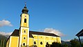
Church in Unterwössen

Village chapel in Hinterwössen

Wössener See

Wössener See

View of the Wilder Kaiser over the Hochgernhaus
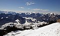
View from Hochgernhaus to Unterwössen


Web links
- Entry on the coat of arms of Unterwössen in the database of the House of Bavarian History
Individual evidence
- ↑ "Data 2" sheet, Statistical Report A1200C 202041 Population of the municipalities, districts and administrative districts 1st quarter 2020 (population based on the 2011 census) ( help ).
- ↑ http://www.bayerische-landesbibliothek-online.de/orte/ortssuche_action.html ? Anzeige=voll&modus=automat&tempus=+20111109/202539&attr=OBJ&val= 580
- ↑ a b Wilhelm Volkert (Ed.): Handbook of the Bavarian offices, communities and courts 1799–1980 . CH Beck, Munich 1983, ISBN 3-406-09669-7 , p. 581 .
- ↑ DWK / ahi: Ex-Federal President: Horst Köhler moves into a vacation home in Bavaria. In: welt.de . July 31, 2012, accessed October 7, 2018 .

Altenmarkt an der Alz | Mountains | Chieming | Engelsberg | Fridolfing | Grabenstätt | Grassau | Inzell | Kienberg | Kirchanschöring | Marquartstein | Nussdorf | Obing | Palling | Petting | Pittenhart | Reit im Winkl | Ruhpolding | Schleching | Schnaitsee | Seeon-Seebruck | Siegsdorf | Staudach-Egerndach | Surberg | Tacherting | Taching at the lake | Tittmoning | Traunreut | Traunstein | Trostberg | Overseas | Unterwössen | Vachendorf | Waging am See | Wonneberg
Unregulated areas: Chiemsee | Waginger See