Wössener See
| Wössener See | ||
|---|---|---|

|
||
| Wössener See | ||
| Geographical location | Alpine foothills | |
| Tributaries | Hacklauer Bach, Rexauer Bach, spring water | |
| Drain | Wössner Bach | |
| Places on the shore | Underweave | |
| Data | ||
| Coordinates | 47 ° 43 '35 " N , 12 ° 28' 17" E | |
|
|
||
| Altitude above sea level | 574.5 m above sea level NN | |
| surface | 4.2 ha | |
| volume | 151,000 m³ | |
| scope | 800 m | |
| Maximum depth | 6.60 m | |
| Middle deep | 3.60 m | |
| Catchment area | 1 km² | |
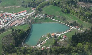
The Wössener See (also Wössner See ) is a small artificial lake in Upper Bavaria in the municipality of Unterwössen in Chiemgau . The lake is located off the beaten track - separated from the B 305 by a small ridge - in a basin behind which the Hochgern ( 1744 m above sea level ) rises. The lake is privately owned and leased by the Unterwössen municipality. Entry to the small open-air swimming pool is free. It is possible to fish.
Emergence
It was not until 1932, when the Hacklauer basin was closed with a dam in the Unterwössen district of Rexau as part of a job creation scheme, that the Wössener See built up behind it. Today it is used for local recreation, as a bathing lake, excellent fishing water and flood retention. The wastewater from the few properties around the Wössener See is drained into the sewage treatment plant of the Achental wastewater association. As a result, the Wössener See has excellent water quality.
Lake and surroundings
Tributaries to the lake: Hacklauer Bach, Rexauer Bach and spring water. Discharge over the overflow of a dam (gradient 7.20 m) into the Wössner Bach - Tiroler Achen - Chiemsee .
Lake Wössen is located in the southern Chiemgau, one of the most popular recreational areas in Bavaria. The scenic attraction arises on the one hand from the immediate proximity of the Chiemgau mountains : ( Hochfelln , Hochgern , Hochplatte , Geigelstein and Kampenwand ) and on the other hand from other lakes in the vicinity: Chiemsee (16 km), Simssee (19 km), Weitsee (18 km), Walchsee in Tirol (22 km).
Districts of Unterwössen, which are located on Lake Wössen:
- Rexau
- Hacklau
- New smith
- Kruchenhausen
Hiking trails to and from Lake Wössen:
- Höhenweg to Marquartstein and to Brem - Oberwössen
- Eglsee (natural monument), Rettenburg ruins, around Kruchenhausen
- Mountain paths to Hochgern, Jochberg, Grundbach and Rechenberg

