
Geigelstein
| Geigelstein | ||
|---|---|---|
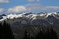
 Geigelstein from the south, seen from the Breitenstein |
||
| height | 1808 m above sea level NHN | |
| location | Bavaria , Germany | |
| Mountains | Chiemgau Alps | |
| Dominance | 11 km → Jovenspitze | |
| Notch height | 1140 m ↓ flood | |
| Coordinates | 47 ° 42 '28 " N , 12 ° 20' 4" E | |
|
||
| Normal way | Ettenhausen - Geigelsteinbahn - Wuhrsteinalm - Wirtsalm - Geigelstein | |

The Geigelstein is 1808 m above sea level. NHN the second highest peak in the Bavarian part of the Chiemgau Alps and known as the Chiemgauer Blumenberg and the observation tower. The Geigelstein is located in the nature reserve NSG-00384.01.
Location and surroundings
The Geigelstein is located between the Prien valley in the west and the Tiroler Ache in the east. In the north it is separated from the Kampenwand by the Dalsensenke . The southern border is the Austrian Kaiserwinkel, in which the Walchsee lies. The Geigelstein area has been a nature reserve since 1991. Because a ski swing and thus several cable cars up the mountain were planned at that time, a citizens' initiative was formed mainly in Schleching , which was able to designate the mountain as a nature reserve. At the highest point of the Geigelstein there is a summit cross and a small chapel. On clear autumn days, the panoramic view extends to the Berchtesgaden Alps in the east, to the nearby Kaiser Mountains and the Großglockner in the south, to the Karwendel in the west and to the Chiemsee in the north.
Geigelstein from the south

Geigelstein from the east, the Breitenstein to the left


Routes to the summit

Mountain hikers are on the Geigelstein in summer and ski tourers and snowshoe hikers in winter . In winter, there is an increased risk of avalanches on the steep slopes. Mostly easy routes lead from all the surrounding valleys to the summit:
- The classic way on the west side
- From Sachrang or Huben via a forest road that climbs steadily in wide bends, shortcuts are possible, in around two hours to the Priener Hütte . From there, a signposted path leads past the Wandspitz in about an hour to the summit. However, surefootedness is required on the last hundred meters through mountain pines and over rocks. This route is also well suited for a ski tour or snowshoe tour. As a variant, you can branch off the forest road in the lower part and take the marked path over the Schreckalm , Sulzingalm and Oberkaseralm to the summit, this is more varied, but not shorter than the normal route via the Priener Hütte. The owner of this house, which is managed all year round, is the German Alpine Association. It offers overnight accommodation and a panoramic view of the Wilder Kaiser.
- The shortest way on the east side
- In the past, hikers used the Geigelstein chairlift to save themselves 500 meters in altitude. The valley station is in Ettenhausen near Schleching , the mountain station on the 1100 meter high Wuhrsteinalm . From there it goes up an alpine road to the Wirtsalm and on a steep, narrow mountain path in around two hours to the summit. This chairlift has been out of service since 2014.
- The way over the northeast side
- For this little-used and therefore quiet ascent, you start in Schleching . From there, a scenic, but sometimes steep, path runs through a small high valley to the Haidenholzalm at an altitude of 1345 m . This can also be reached from Ettenhausen via a forest road. From there it goes past the Weitlahnerkopf up to the Roßalm , the highest alpine pasture in the Chiemgau at 1681 meters. Finally, it goes south through mountain pines past the Roßalpenkopf to the Geigelsteingipfel. Walking time uphill three hours, one way 7.5 km. This path, which is the most demanding compared to the other paths, should only be used by experienced hikers with good shoes and hiking sticks.
- The Tyrolean way on the south side:
- A tour to Geigelstein can also begin in Austria, for example in Walchsee . From there you follow a gravel path over the Baumgartenalm up to the Priener Hütte , this route is also covered by mountain bike. Then continue on a steep mountain climb to the summit, which is reached after a total of four hours.
Neighboring peaks
The neighboring peaks can also be reached on marked trails , including the Breitenstein ( 1661 m ), the Weitlahnerkopf ( 1615 m ), the Wandberg ( 1454 m ) and the Rudersburg ( 1430 m ) the more well-known with summit crosses and far-reaching views. There are also a number of other, less visited mountains in the Geigelstein area. These include the Roßalpenkopf ( 1764 m ), the Mühlhörndl ( 1520 m ), the Hochköpfl ( 1543 m ), the Karkopf ( 1510 m ) and the Sandspitz ( 1493 m ).
Nature reserve

In 1991, large areas of the Geigelstein were designated as the Geigelstein nature reserve. The NSG Geigelstein has a size of 3135 hectares and is partly in the district of Rosenheim with the municipality of Aschau , and in the district of Traunstein with the municipality of Schleching . With one of the largest protected areas on Bavarian soil, it is primarily the sensitive and rare alpine vegetation at high altitude that is protected. The expulsion was preceded by a fierce argument between supporters and opponents for over 15 years.
In 1975 the citizens' initiative "Rettet den Geigelstein" was founded because of a planned ski swing and various mountain railway projects on the summit as well as a protection idea. Their aim was to put the area of the mountain under nature protection and thus also to prevent the construction of a cable car.
According to surveys, there are around 720 species of ferns and flowering plants on Geigelstein , 111 of which are protected species (FFH species). That is why the Geigelstein is sometimes referred to as the “Chiemgau's Flower Mountain”. The traditional alpine farming that is characteristic of the Chiemgau Alps was continued and promoted to the previous extent on light pasture areas. This is necessary in order to preserve the cultivated landscape and to prevent natural succession with bush encroachment.
Recreational sports such as mountain biking , paragliding as well as ski and snowshoe tours are still possible, but severely restricted. Fauna and flora have priority here, e.g. B. Local entry bans during the breeding season.
On Geigelstein live Tengmalm, hazel, black grouse , capercaillie and ptarmigan . Since 2000 a pair of golden eagles has been documented in the outskirts of the community of Aschau, one in the Geigelstein area and one in the Hochries area. Peregrine falcons also breed in the region around the mountain.

Bergen moss | Breakthrough valley of the Tiroler Achen | Terminal moraine pond south of Asten | Geigelstein | Hacken and Rottau felt | Kendlmühlfilzen | Mettenhamer felt | Mouth of the Tiroler Achen | Eastern Chiemgau Alps | Schönramer Moor | Seeon Lakes | Sossauer Filz and Wildmoos | Süssener and Lanzinger Moos
literature
- Heinrich Bauregger: Chiemgau ; Bergverlag Rother , Munich; ISBN 3-7633-4109-9
- Birgit Gelder: Bavarian Alps Bergverlag Rother, Munich; ISBN 3-7633-3020-8
- Wolfgang Tascher / Michael Reimer: Winter hiking in the Bavarian local mountains ; Bruckmann; ISBN 3-7654-3673-9
- Markus Stadler: Ski tour guide Bavarian Alps. 1st edition. Panico-Alpinverlag, Köngen 2007, pp. 132-135, ISBN 978-3-936740-40-0 .
- Reinhard Rolle: Hut hiking between Garmisch and Berchtesgaden. 1st edition. Edition Förg, Rosenheim 2008, p. 89, ISBN 978-3933708304 .
panorama

Web links
Individual evidence
- ^ ProtectedPlanet.net
- ↑ Geigelsteinbahn. (No longer available online.) Archived from the original on September 24, 2014 ; Retrieved June 9, 2014 . Info: The archive link was inserted automatically and has not yet been checked. Please check the original and archive link according to the instructions and then remove this notice.
- ↑ The Geigelsteinbahn has been standing still for months. In: Traunsteiner Tagblatt. January 16, 2014, accessed February 2, 2017 .
- ↑ Martin Schmölling: Geigelstein nature reserve. Alpine Club Section Prien, accessed on September 16, 2016 .