
Kupferbachtal
|
NSG Kupferbachtal near Unterlaus
|
||
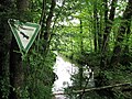
 Kupferbachtal northwest of Oberstetten |
||
| location | District of Munich , District of Rosenheim , District of Ebersberg , Bavaria | |
| surface | 45.47 ha | |
| Identifier | NSG-00177.01 | |
| WDPA ID | 164300 | |
| Geographical location | 47 ° 57 ' N , 11 ° 51' E | |
|
||
| Setup date | 1983 | |

The nature reserve "Kupferbachtal bei Unterlaus" is a flat and hillside spring moor that extends over the communities of Feldkirchen-Westerham ( district of Rosenheim ) and Aying ( district of Munich ) as well as the market Glonn ( district of Ebersberg ). The Kupferbachtal was created at the end of the last ice age when the meltwater from the Inn-Chiemsee glacier and partly from the Isar glacier could not drain into the Rosenheim basin, which was still filled with ice, and thus after a long period of standstill (so-called Ellkofener stage) at the edge of the glacier Flowed northeast in the direction of Wasserburg or Gars towards the Inn ("Umfließungsrinne"). The bypass channel was formed and used in the period from approx. 18,000 years to approx. 16,500 to 17,000 years ago. Today the area is characterized by several strong calcareous springs.
Protection purpose
The area extends over three districts with an area of 46.4 hectares . The protection purpose of the nature reserve "Kupferbachtal bei Unterlaus" is to protect the rare and almost undisturbed limestone moorland. In addition, the habitat for rare and endangered plants and animals should be preserved. This includes in particular the Bavarian spoonweed (Cochlearia bavarica), which only occurs in southern Bavaria . In addition to Schneidried and Mehlprimel - Kopfbinsen -Gesellschaften u. a. the creeping celery (Apium repens) .
protection and care
Various maintenance measures have been carried out both in the district of Munich and in the Rosenheim area by the landscape conservation association "Munich-Land". The Kupferbachtal, together with the Glonn springs and the Gutterstätter litter meadows with Attelleite, are designated as an FFH area according to the European nature conservation directive . In addition, 313 hectares of the adjacent areas in the district of Ebersberg and 77 hectares in the district of Rosenheim are under landscape protection (LSG "Kupferbachtal und Umgebung" in Markt Glonn and the municipality of Egmating; protection of the Kupferbachtal as LSG in the district of Bad Aibling ).
photos
Kupferbach near Spielberg

Bridge over the Kupferbach

Reeds two meters high hide the stream


Individual evidence
- ↑ Protected planet: Kupferbachtal near Unterlaus Retrieved on February 25, 2016.
- ↑ 8037-371 Kupferbachtal, Glonnquellen and Gutterstätter Streuwiesen. (FFH area) Profiles of the Natura 2000 areas. Published by the Federal Agency for Nature Conservation . Retrieved November 28, 2017.
Web links
- Ordinance on the nature reserve with site plan, 1983 (PDF file; 394 kB)
