Kupferbach (Glonn)
| Kupferbach | ||
|
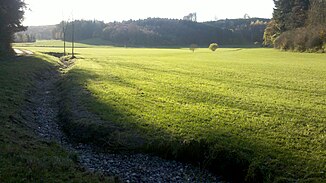
Headwaters of Kupferbach (here Graben is still dry) |
||
| Data | ||
| location | Upper Bavaria | |
| River system | Danube | |
| Drain over | Glonn → Mangfall → Inn → Danube → Black Sea | |
| source | at Percha | |
| Source height | 574 m | |
| muzzle | Markt Glonn in Glonn Coordinates: 47 ° 59 ′ 10 ″ N , 11 ° 52 ′ 11 ″ E 47 ° 59 ′ 10 ″ N , 11 ° 52 ′ 11 ″ E |
|
| Mouth height | approx. 480 m | |
| Height difference | approx. 94 m | |
| Bottom slope | approx. 13 ‰ | |
| length | approx. 7 km | |
The Kupferbach is a river in Upper Bavaria .
It rises in Rosenheim near percha , flows in a northerly direction, including through the rascals pond , the place Unterlaus and the conservation area Kupferbachtal and ends in the district of Ebersberg in the market Glonn in Glonn .
