
Hochfelln
| Hochfelln | ||
|---|---|---|
 The Hochfelln seen from the southeast (from the Unternberg ) |
||
| height | 1674 m above sea level NHN | |
| location | Bavaria | |
| Mountains | Chiemgau Alps | |
| Coordinates | 47 ° 45 '44 " N , 12 ° 33' 33" E | |
|
||
| rock | Triadic and Jurassic Dolomites and Limes | |
| particularities | Fossil- rich Hochfelln layers | |

The Hochfelln is a mountain in the Chiemgau Alps with a height of 1674 meters above sea level near Bergen in the Upper Bavarian district of Traunstein . A neighboring mountain is the Hochgern .
tourism
The summit can be climbed on foot, but the Hochfelln cable car also leads from Bergen with a stop halfway up the mountain ( Bründlingalm ) to the top. Immediately next to the summit cross is the Hochfellnhaus , the highest gastronomic establishment in the Chiemgau . Around 80 meters south of the summit cross is the highest point of the Hochfelln, there is the Tabor Chapel with the patronage of the Transfiguration of Christ . It burned down in a thunderstorm in the winter of 1971 and was rebuilt. One ascent from Bergen is hiking trail no. 10 from the Weißachental. From Ruhpolding , sure-footed people can climb over the Strohnschneid, the path over the Thoraualm is easier and less prone to falling .![]()
![]()

Summit cross of the Hochfelln and Hochfellnhaus
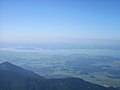
View from Hochfelln to the Chiemsee

View from the east to Tabor Chapel, Hochfellnhaus, mountain station of the Hochfelln cable cars (from left)


See also
Individual evidence
- ^ Outline of a thesis on the geology of the Hochfelln ; Retrieved October 17, 2011.
Web links
- The Hochfelln at alpen-bayern.de
- hochfelln.de - Commercial portal