
Palling
| coat of arms | Germany map | |
|---|---|---|

|
Coordinates: 48 ° 0 ' N , 12 ° 38' E |
|
| Basic data | ||
| State : | Bavaria | |
| Administrative region : | Upper Bavaria | |
| County : | Traunstein | |
| Height : | 531 m above sea level NHN | |
| Area : | 53.86 km 2 | |
| Residents: | 3492 (Dec. 31, 2019) | |
| Population density : | 65 inhabitants per km 2 | |
| Postal code : | 83349 | |
| Area code : | 08629 | |
| License plate : | TS, LF | |
| Community key : | 09 1 89 134 | |
| Community structure: | 57 districts | |
| Address of the municipal administration: |
Bräuanger 1 83349 Palling |
|
| Website : | ||
| Mayor : | Franz Ostermaier (list of employees) | |
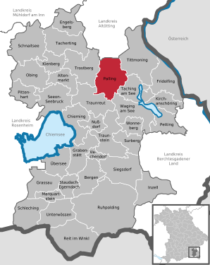
| Location of the municipality Palling in the district of Traunstein | ||
  |
||


Palling is a municipality in the Upper Bavarian district of Traunstein .
Community structure
The 57 districts are:
history
Prehistory and early history
The prehistory and early history of palling has only been researched in the last few decades. In 1968 a completely preserved stone battle ax from the Neolithic Age was found in the northern part of the municipality . Such battle axes or battle hammers speak for the culture, which around 1800/1700 BC. Was widespread in the northern Alps. In May 1976, students came across a broken Neolithic hole ax. In 1977 there were three more finds. These are parts of two battle axes from the Neolithic Age and a medieval clay vessel that has disintegrated into several parts. In the west rising woods of Pallinger mountain nor Hochäcker to see that the Celts are expected to decline. The corrugated hollows and walls are four to five meters long. The section of a Roman road from Katzwalchen to Pasee has been documented from Roman times . A well-preserved Roman stone can be found at the entrance to the Freutsmoos church. The Bavarians took the land . They buried their dead in long rows side by side and one behind the other. Such row graves with graves were discovered in Brünning and Unterhafing. The center of Palling is on a Bavarian cemetery. Finds from these row graves are seven rings made of bronze, only one of which has survived and four smaller bronze rings and a ring-shaped handle made of bronze. In 1969 an 8 cm long bronze belt buckle and a 73 cm long iron sword were found, in 1979 a 7th century Sachs and in 1973 a spathe , a long sword.
From 788: In addition to the numerous archaeological finds in the parish of Palling, which provide important information about the settlement and way of life of the then resident population, the written sources begin in the 8th century. In the Notitia Arnonis (788/790), in which the Salzburg (arch) bishop Arn wanted to have confirmed the donations of the Agilolfinger dukes and the lower nobility of Charlemagne , the first mention of places of the parish Palling was made. These are the places Brünning, Palling, Schilding and Tyrlbrunn. In the year 798 the places Freutsmoos and Heigermoos are mentioned for the first time. The Gaue (pagi) were the most important form of organization for property and administration in the Agilolfinger period. According to Notitia Arnonis, Tyrlbrunn was in the Salzburggau . For the other places mentioned in the parish, a clear assignment to Salzburg or Chiemgau is not possible, but it can be assumed with some certainty that the entire area of today's parish Palling was in Salzburggau, as was the political affiliation to Salzburg (from 1275 ) shows.
In 788 the place Palling is mentioned for the first time as Baldilingas with its own church and the side churches Brünning and Schilding. The church in Schilding was probably destroyed during the Hungarian and Avar invasions . During this time there was probably a refuge to the northwest on Pallinger Berg . Remains of the Palling section fortification (section wall) can still be found here .
Middle Ages to the turn of the century


The plague time of 1633/34 brought a lot of misery to the area. The Pesthölzchen at Ranham and the Pestmarterl at Schilding remind of this. The veneration of Saint Sebastian continues today (Sebastianiamt, Sebastiankerze, Sebastianirosenkranz). Next to the south portal in the parish church there is a life-size baroque statue of Saint Sebastian.
During the Napoleonic Wars (1792 / 93-1797 and 1798-1801 / 02) Palling suffered greatly under military swipes, billeting , forced labor , high taxes and looting . Emerentia Kasperlschusterin, a farmer from Einsiedl, was killed by a second shot when she tried to flee from French looters and the first bullet did not stop her.
In 1810 the Rupertiwinkel came to the Kingdom of Bavaria . Salzburg lost its sovereign rights. An old boundary stone on the roadside in the ground between Brünning and Weißenkirchen reminds of this . In the southern vestibule of the church, embedded in a sheet metal book, Jakob Wimmer from Katzwalchen reports on his participation in the Russian campaign in 1812 and the battles in Bar and Brienne in 1814.
From 1803 to 1810 the parish of Palling changed rulers four times. After the Reichsdeputationshauptschluss of February 25, 1803, by which the sovereign rights were withdrawn from the Prince Archbishop , the area belonged to the newly formed Electorate of Salzburg, which was transferred to the Grand Duke Ferdinand of Tuscany for two years . With the Peace of Pressburg (December 26, 1805) Salzburg came under the crown of Emperor Franz I of Austria , the Peace of Schönbrunn of 1809 placed the area under French rule and the Frankfurt Treaty of 1810 finally brought it under Bavarian rule. By the State Treaty of April 14, 1816, the former Salzburg area was separated into an Austrian and a Bavarian part, the Rupertiwinkel , to which Palling belongs. There were no more changes for Palling in 1816; it had been Bavarian since 1810.
The parishes Palling and Freutsmoos, formed in 1818, belonged to the parish of Palling. In addition, the Lindach school exposition was added to the parish in 1809 , which was part of the Palling parish until 1937. The municipalities of Palling and Freutsmoos were subordinate to the Tittmoning district court and from 1862 - after the separation of justice and administration - to the Tittmoning district court and the Laufen district office , which since 1937 bore the name " Laufen district office ".
In 1893 a hospital was opened in Palling. Sisters of Charity took care of them. It was supported by the municipalities Palling, Freutsmoos, Lindach and Heiligkreuz. Today it is run as a retirement and nursing home .
In 1897 Pastor Heringer called the von Anger school sisters in Munich to run the girls' school and the infant care facility.
Modern times
When the construction of the Mühldorf – Freilassing railway began in 1894 , it was originally assumed that the railway would pass near Palling. For example, a restaurant was renamed Zum Bahnhof . Later, however, there were protests by some Pallinger citizens against the course of the railway line. In addition, the Kirchweidach pastor and a landlord from Tyrlaching intervened , so that the railway line was built much further east in 1908. The restaurant was operated under the name Zum Bahnhof until 2007 , even if there is or was no train station in Palling. The building was demolished in 2012.
In the First World War 1914/18, 99 soldiers from the Palling area and in the Second World War 1939/45 110 soldiers died and 16 were missing. In 1942 the bells were removed from the tower and melted down as war material. Only the smallest, the Laurence bell, was allowed to remain in the tower.
In 1944 and 1945, mass quarters had to be provided for refugees and those who had been bombed out. It came from Transylvania , Hungary German , Vienna , Silesia and Hamburg . 1255 displaced people came to the community. Between 1939 and 1945 the population rose from 1549 to 2700. Initially, the refugees were housed in agriculture.
May 4, 1945: Entry of the Americans . The mayor Schedl is captured. He was shot between Freutsmoos and Heilham. The locals had to leave the village for ten days. The houses were looted. The farmers were allowed to go home in the evening to milk the cows.
1946: The demolition of an ammunition dump in Hörpolding caused damage to buildings and the church.
From 1948 to 1951, around 800 displaced persons poured into the industry. Factories in Traunreut (Siemens, Heidenhain), Trostberg (SKW) and Altenmarkt (Alzmetall) created jobs. The exodus from agriculture began. There was no settlement option at the place itself. The mechanization, rationalization and expansion of the farms followed.
On October 1, 1950, the government of Upper Bavaria re-established the municipality with the name Traunreut from parts of the municipalities Palling, Pierling, Stein an der Traun and Traunwalchen.
On January 1, 1978, the Pierling community was dissolved. Its main part was incorporated into the city of Traunreut . An area with just over 100 inhabitants came to Palling. The previously independent municipality of Freutsmoos was incorporated on the same day.
Population development
Between 1988 and 2018 the municipality grew from 2,912 to 3,486 by 574 inhabitants or 19.7%.
- 1961: 2632 inhabitants
- 1970: 2549 inhabitants
- 1987: 2905 inhabitants
- 1991: 3025 inhabitants
- 1995: 3149 inhabitants
- 2000: 3321 inhabitants
- 2005: 3385 inhabitants
- 2010: 3376 inhabitants
- 2015: 3460 inhabitants
politics
Franz Ostermaier (list of employees) has been in office since May 1, 2020; he was elected on March 15, 2020 with 77.25% of the vote. His predecessor was Josef Jahner (Independent Voting Association), in office from May 1996 to April 2020.
The municipal council will be composed as follows for the 2020 to 2026 term:
- Workers list: 4 seats (21.90%)
- Independent constituency: 3 seats (20.70%)
- CSU: 3 seats (20.50%)
- Citizens' list: 3 seats (18.60%)
- Free voter community: 3 seats (18.30%)
The turnout was 66.92%.
Attractions
_2.jpg)
- One of the sights in the parish of Palling is the stately neo-Gothic parish church of the Birth of Mary , consecrated in 1876, with its 75 meter high steeple, which Joseph Cardinal Wendel once said during a visit that it almost became a cathedral.
- The Kalvarienberg, renovated and visible from afar, is of national importance.
- Parsonage chapel of the former parsonage
- One of the newer attractions is the Kneipp facility on the community meadow, where the folk festival is held every year in the summer of July.
- Since the summer of 2005, two are wind turbines of the type REpower M77 with a rated output of 1.5 megawatts . With a rotor diameter of 77 meters and a tower height of 100 meters, the total height is 138.5 meters.
See also: List of architectural monuments in Palling
Soil monuments
See: List of ground monuments in Palling
Economy and Infrastructure
Economy including agriculture and forestry
In 1998, according to official statistics, there were no employees at work subject to social security contributions in the manufacturing industry or in trade and transport. In other economic areas 124 people were employed at the place of work subject to social security contributions. There were a total of 1023 employees at the place of residence subject to social security contributions. There were none in the manufacturing sector and eight in the construction sector. In addition, there were 158 farms in 1999 with an agriculturally used area of 3,104 hectares, of which 1,682 hectares were arable land and 1,421 hectares were permanent green space.
education
The following institutions exist (as of 2015):
- two day-care centers with 137 places and 99 children (including ten under three years of age and 20 over six years old)
- a primary school with four classes and 121 students
Personalities
- The Huberbuam : Thomas Huber (* 1966 in Palling) and Alexander Huber (* 1968 in Trostberg), two mountaineers and extreme climbers, grew up in Palling.
- Christian Krettek (* 1953 in Palling), German surgeon, trauma surgeon and university professor at the Hannover Medical School grew up in Palling and attended elementary school here.
- Bishop Georg von Oettl (* 1794 in Gengham / Palling; † 1866)
- Benedikt Huber (* 1989 in Traunstein), German athlete, 2016 - 2018 German champion in the 800 m run
Individual evidence
- ↑ "Data 2" sheet, Statistical Report A1200C 202041 Population of the municipalities, districts and administrative districts 1st quarter 2020 (population based on the 2011 census) ( help ).
- ↑ http://www.bayerische-landesbibliothek-online.de/orte/ortssuche_action.html ? Anzeige=voll&modus=automat&tempus=+20111108/212155&attr=OBJ&val= 562
- ^ Demolition of the train station restaurant In: heimatzeitung.de, January 19, 2012
- ^ Wilhelm Volkert (ed.): Handbook of Bavarian offices, communities and courts 1799–1980 . CH Beck, Munich 1983, ISBN 3-406-09669-7 , p. 582 .
- ^ Federal Statistical Office (ed.): Historical municipality directory for the Federal Republic of Germany. Name, border and key number changes in municipalities, counties and administrative districts from May 27, 1970 to December 31, 1982 . W. Kohlhammer GmbH, Stuttgart / Mainz 1983, ISBN 3-17-003263-1 , p. 593 .
Web links
- Entry on Palling's coat of arms in the database of the House of Bavarian History

Altenmarkt an der Alz | Mountains | Chieming | Engelsberg | Fridolfing | Grabenstätt | Grassau | Inzell | Kienberg | Kirchanschöring | Marquartstein | Nussdorf | Obing | Palling | Petting | Pittenhart | Reit im Winkl | Ruhpolding | Schleching | Schnaitsee | Seeon-Seebruck | Siegsdorf | Staudach-Egerndach | Surberg | Tacherting | Taching at the lake | Tittmoning | Traunreut | Traunstein | Trostberg | Overseas | Unterwössen | Vachendorf | Waging am See | Wonneberg
Unregulated areas: Chiemsee | Waginger See