Zettenkaiser
| Zettenkaiser | ||
|---|---|---|
|
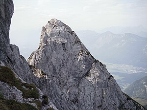
Zettenkaiser from the northeast |
||
| height | 1968 m above sea level A. | |
| location | Tyrol , Austria | |
| Mountains | Kaiser Mountains | |
| Dominance | 0.19 km → Scheffauer | |
| Notch height | 76 m ↓ Brooding gap | |
| Coordinates | 47 ° 33 '25 " N , 12 ° 14' 8" E | |
|
|
||
| Normal way | Kufstein or Hintersteiner See - Kaindlhütte - Large and Small Cemetery - Zettenkaiser | |
|
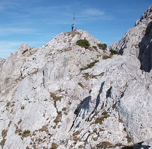
Summit structure of the Zettenkaiser with summit cross, seen from the normal route from the west |
||
The Zettenkaiser is a 1968 m high mountain with a summit cross in the Kaiser Mountains in the Northern Kalkapen .
location
The Zettenkaiser is part of the elongated ridge in the western part of the Kaisergebirge, which extends from the Zettenkaiserkopf to the Sonneck . It is separated by a notch (Grübler Lucke) from the almost 150 m higher Scheffauer , which adjoins to the east. To the west, several ridge towers and notches separate it from the Brooding Kaiser . To the east is the Kaindlnadel at the foot of the summit . The summit, with a pronounced, sometimes very narrow ridge, falls south and east through steep rock faces, partly interspersed with mountain pines and grass chippings, to the Hintersteiner See (south) and the Steinbergalm . It is one of the rarely visited peaks in the Kaiser Mountains. View to the south to the main Alpine ridge, to the north to the Zahmer Kaiser and to the west to the Inn Valley and to the east to the Scheffauer.
Routes
The summit can only be reached by experienced mountaineers, even the normal route is very demanding and very exposed on the long ridge.
The marked normal path (Riegensteig) starts at the private Kaindlhütte (1293 m) on the Steinbergalm, leads over the large and small cemetery (two cirques), then to approx. 1700 m after overcoming a 3 to 4 m high rock step (II +) (can also be bypassed on the right) to reach the west ridge through gutters in the mountain pine area. The ridge has no particular difficulties (I), is mostly exposed and therefore requires surefootedness and a head for heights. There is no insurance and the markings have faded in places (as of 2015); if you deviate from the route, the path becomes significantly more difficult. Time required from the Kaindlhütte about 2 hours.
The variant of a summit ascent via the Nordwandsteig , which branches off from the normal route in the small cemetery and joins the normal route directly below the summit, is even more challenging . Finding a route is difficult, it takes about 1.5 hours from Kaindlhütte.
The Zettenkaiser is also a popular climbing mountain. In particular, crossing the western ridge from the Brooding Kaiser to the summit is more frequent (II – III). The start of this route on the Grübler Kaiser is reached from Hochegg via steep tracks, a short rock step (II), through Latschengassen and over the ridge (walking area, I, points II, two points III) (shortly after the junction from the marked Walleralm mountain trail - Kaindlhütte begins with red markings that lead up to the Brooding Kaiser). Climbers also cross the summit over to the Scheffauer (by abseiling into the Grübler Lucke). There are also numerous climbing routes in the north face / east face. The upstream Kaindlnadel is also a destination for climbers.
Literature and map
- Horst Höfler , Jan Piepenstock: Alpine Kaiser Mountains. Alpine Club Guide for hikers and mountaineers (= Alpine Club Guide ). 12th edition. Bergverlag Rother, Munich 2006, ISBN 3-7633-1257-9 .
- Pit Schubert : Extreme Kaiser Mountains. Alpine club guide for climbers (= Alpine club guide ). Bergverlag Rother, Munich 2000, ISBN 3-7633-1272-2
- Alpine Club Map 1: 25,000, Kaiser Mountains , sheet 8.


