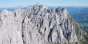
Törlspitzen
| Törlspitzen | ||
|---|---|---|
|
The Törlspitzen from the west, in the middle the Goinger Scharte, on the left the Vordere Goinger Halt , in the back in the middle the Ackerlspitze |
||
| height | 2227 m above sea level A. | |
| location | Tyrol , Austria | |
| Mountains | Kaiser Mountains | |
| Dominance | 0.5 km → Vordere Goinger Halt | |
| Notch height | 142 m ↓ Goinger Scharte | |
| Coordinates | 47 ° 33 '36 " N , 12 ° 19' 44" E | |
|
|
||
| rock | Wetterstein lime | |
| Age of the rock | Ladinium - Lower Carnium | |
| Normal way | From the Griesener Kar over the saddle between Goinger Turm and Goinger Törlspitze to their summit | |
|
Northern part of the Törlspitze from the east: Northern Törlspitze (left), Bauernpredigstuhl (front left), Goinger Turm (center), Goinger Törlspitze (right next to it), Westliches Törleck (right), Eastern Törleck (far right) |
||
The Törlspitzen form a mountain group in the Kaiser Mountains in Tyrol . They are multi-peaked and consist of eight peaks that belong to the municipality of Kirchdorf in Tirol . The border with the municipality of Going am Wilden Kaiser runs over the southern part of the summit .
location
The Törlspitzen are located in the central part of the Kaisergebirge at the transition to the Ostkaiser. You ascend southeast of the Ellmauer Tor . To the west, the peaks drop in steep rock faces towards the Kübelkar. To the south, the pronounced rock faces merge into exposed terrain with steep grass ridges and rocky terrain. On the east or north side of the Törlspitzen there is the Griesener Kar , an extensive scree field that sometimes reaches far up towards the summit of the Törlspitzen. The northern corner point of the Törlspitzen is the Nördliche Törlspitze or the Goinger Scharte , the southern end of the Törlspitzen is the Kreuztörlturm or the Kleine Törl . To the north, the Törlspitzen is preceded by the Vordere Goinger Halt , from which they are separated by the Goinger Scharte. To the southeast follows the main ridge with the small Törl and the Regalmspitze , which finally culminates in the Ackerlspitze in the Ostkaiser.
summit
From north to southeast:
- Northern Törlspitze (2187 m)
- Farmer's Sermon Chair (2119 m)
- Goinger Tower (2201 m)
- Goinger Törlspitze (2227 m)
- Western Törleck (2198 m)
- Eastern Törleck (2198 m)
- Highest Törlturm (2191 m)
- Kreuztörlturm (2173 m)
The most striking peaks are the Bauernpredigtstuhl and the Kreuztörlturm , the highest point is the Goinger Törlspitze .
Routes
All summits of the Törlspitzen can only be reached by climbing and are not marked; they therefore require surefootedness, a head for heights, alpine experience, a sense of direction and climbing skills. This part of the Kaiser Mountains is rarely visited.
The entrances to the summit routes can be reached either from the north from the Kaiserbachtal via the Große Griesener Tor or the Kleine Griesener Tor via Fritz-Pflaum-Hütte and the mountain path towards Kleines Törl . From the south, the south-eastern area of the mountain group can be reached via the Gildensteig from Going or the Wochenbrunneralm via the Kleien Törl . The northwestern peaks can also be climbed from the west from the Kübelkar .
The most famous climbing summit of the Törlspitzen is the Bauernpredigstuhl , on which several climbing routes lead up from the Kübelkar (easiest route still taken today, grade of difficulty according to UIAA scale ).
The highest peak is the Goinger Törlspitze at 2227 m . It is also the easiest to reach summit of the Törlspitzen. The normal route (II) begins in the Griesener Kar on the northeast side of the summit. You can get here either via the Großer Griesener Tor or the Kleiner Griesener Tor from the Kaiserbachtal , or from the south via the Gildensteig and the Kleiner Törl . From the Hochkar you first head for the gap between the Goinger Turm and the Goinger Törlspitze. From there over ribbons and gullies up to the summit. It takes about one and a half hours from the entrance in the Griesener Kar.
Another popular climbing summit is the Kreuztörlturm, which can be climbed from the Kleiner Törl (easiest route III +).
bases
The Fritz-Pflaum-Hütte (self-catering hut, only accessible with an AV key), the Ackerlhütte (self-catering hut) to the southeast, the Gaudeamushütte to the southwest or the Gruttenhütte (to the west) serve as bases to the northeast of the mountain section .
Literature and map
- Horst Höfler , Jan Piepenstock: Alpine Kaiser Mountains. Alpine Club Guide for hikers and mountaineers (= Alpine Club Guide ). 12th edition. Bergverlag Rother, Munich 2006, ISBN 3-7633-1257-9 .
- Pit Schubert : Extreme Kaiser Mountains. Alpine club guide for climbers (= Alpine club guide ). Bergverlag Rother, Munich 2000, ISBN 3-7633-1272-2
- Alpine Club Map Sheet 8: Kaiser Mountains , 1: 25,000, 8th edition, Munich 2012, ISBN 978-3-928777-23-0


