
Head claws
| Head claws
Headache
|
||
|---|---|---|
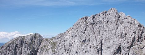
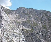
 Kopfkraxn from the northeast |
||
| height | 2178 m above sea level A. | |
| location | Tyrol , Austria | |
| Mountains | Kaiser Mountains | |
| Dominance | 0.2 km → Sonneck | |
| Notch height | 38 m ↓ Scharte to the Sonneck | |
| Coordinates | 47 ° 33 '44 " N , 12 ° 16' 40" E | |
|
||
| rock | Wetterstein lime | |
| Age of the rock | Upper upper anisium - Lower Carnium | |
| Normal way | Scheffau - Kaiserhochalm - Kopfkraxen | |
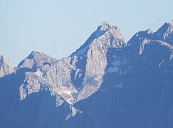
 Kopfkraxn from the southeast, seen from the Tuxeck |
||
 Sonneck (center) from the southwest, to the right behind the Ellmauer Halt , in front right the Schneekar, in the foreground Wiesberg and Kopfkraxn |
||

The Kopfkraxen (also Kopfkraxn ) is a 2178 m above sea level. A. meter high mountain in the Kaiser Mountains in Tyrol . There is a stone man on its rather narrow summit . The summit offers a good view of the Sölllandl , the views of the Untere Gamskarköpfl , the Treffauer , the Tuxeck and the SkiWelt Wilder Kaiser - Brixental are particularly attractive .
location
The Kopfkraxn Sonneck rises in the western part of the Wilder Kaiser in the main ridge between the Hackenkopf , the Sonneck in the east and the Treffauer further south-east. It is characterized by its distinctive ridge in an east-west direction. To the north, the Kopfkraxn falls in high, steep walls with grass chaff down to the Gamskar . In the south, the Kopfkraxn forms a steep, roughly 400-meter-high, highly structured wall structure above the snow car . On the south side, the Sonneck has steep, high rock faces above the Schneekar , which are criss-crossed by several climbing routes (e.g. Kraxngrat, IV-). On the east side, the long ridge of the Kopfkraxn merges into the Wiesberg , to the east the Sonneck is separated by a clear notch (steep rock break off there on the side of the Kopfkraxn). The peak belongs to the municipality of Kufstein .
Routes
The Kopfkraxn is one of the more easily accessible peaks of the Kaiser Mountains. It can be easily reached either from the south or from the east via two marked trails for experienced and trained mountaineers.
- South route : 3.5 hours ascent, 2.5 hours descent, 1290 meters in altitude
The starting point for this route is Scheffau am Wilden Kaiser . You can drive to the Gasthaus Jägerwirt (910 m), from there on foot, initially quietly over forest and meadow terrain. The Kaiser-Hochalm is reached after one and a half hours, then it becomes steeper, past the south side of the Sonnenstein, then over pine slopes and open, rugged terrain, strenuous on the ridge and over this or on the west side avoiding a good path to the Kopfkraxen. On sunny, hot days you have to start early, otherwise this ascent will be torture. Surefootedness required; the last piece also requires a head for heights. Some places with difficulty I.
- North route : 7.5 hours ascent, 6.5 hours descent, 1860 meters of altitude
The starting point for this route is Sparchen, a district of Kufstein . First of all, a longer hike has to be accepted, which is, however, extremely scenic. In 2.5 hours it goes through the Kaisertal past Pfandlhof and Antonius Chapel to the Anton-Karg-Haus in Hinterbärenbad . You can spend the night there. The marked but rarely used route follows the Bettlersteig in the direction of the Kaindlhütte for half an hour until the Güttler-Steig branches off to the Sonneck. At first not too exciting, the path leads pleasantly uphill through the forest in serpentines until it descends over a rock step (secured by wire rope, defused with iron stirrups) and then leads up through a large scree field (Kühkarl). Then it goes on a continuously steep incline through rugged terrain, partly exposed (one place secured by wire rope) up to Gamskar (scree field, which rightly bears its name). From there, the path leads partly over rocks (defused with a few iron stirrups) and through mountain pines up to the Lower and Upper Gamskarköpferl and finally through a scree cirque to the extensive summit field of the Sonneck. Here one does not go all the way up to the summit, but branches off to the southwest across the west ridge of the Sonneck. There the marked, exposed and secured climb leads through the notch up to Kopfkraxn. Some places with difficulty level I. Surefootedness and a head for heights required. Overall longer, but a little easier than the southern route.
- Ridge crossing towards Scheffauer via Hackenköpfe
It is possible to cross the entire ridge from the Kopfkraxen over the Wiesberg and the Hackenköpfe to the Scheffauer . However, this route is strenuous, lengthy, not continuously marked or secured, in addition, in parts quite exposed and spiced up with several counter-climbs and numerous climbing points up to difficulty level II. It may only be climbed by sure-footed and vertigo-free mountaineers with local knowledge and alpine experience. The entire transition from the Kopfkraxn to the Scheffauer takes about 2.5 to 3.5 hours, after which you have to descend either to the Kaindlhütte or to the Hintersteiner See or Jägerwirt (Scheffau). This ridge crossing is usually done in the opposite direction, since the more difficult parts are then on the ascent; their length and difficulty are often underestimated.
- Climbing routes
The south face of the Kopfkraxn is very popular among climbers; There are numerous routes from the IV. level of difficulty (e.g. Kraxngrat, IV-), which can be reached via the Schneekar (you can get there via the marked normal route of the Treffauer).
photos

Wiesberg (left) and Kopfkraxn (right) from the south
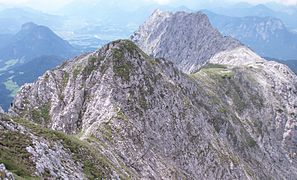
Kopfkraxn (left) and Sonneck (right) with a connecting ridge from the southeast
Transition from the Sonneck to the Kopfkraxn from the east, in the further course of the ridge the Wiesberg , the Hackenköpf and the Scheffauer
Sonneck (center), Kaiserkopf (left), Kopfkraxn (right), in front the Obere Gamskarköpfl and on the right in front the Untere Gamskarköpfl (Kufsteiner Klettersteig )
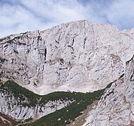
South face of the Kopfkraxn (climbing routes), lower left the waterfall
The north face of the Kopfkraxn above the Gamskars , on the left the ridge crossing with the saddle to the Sonneck , seen from the Lower Gamskarköpfl


Literature and map
- Horst Höfler , Jan Piepenstock: Alpine Kaiser Mountains. Alpine Club Guide for hikers and mountaineers (= Alpine Club Guide ). 12th edition. Bergverlag Rother, Munich 2006, ISBN 3-7633-1257-9 .
- Pit Schubert : Extreme Kaiser Mountains. Alpine club guide for climbers (= Alpine club guide ). Bergverlag Rother, Munich 2000, ISBN 3-7633-1272-2
- Alpine Club Map Sheet 8: Kaiser Mountains , 1: 25,000, 8th edition, Munich 2012, ISBN 978-3-928777-23-0