
Saalfelden at the Stone Sea
|
Borough Saalfelden at the Stone Sea
|
||
|---|---|---|
| coat of arms | Austria map | |
 |
|
|
| Basic data | ||
| Country: | Austria | |
| State : | Salzburg | |
| Political District : | Zell am See | |
| License plate : | ZE | |
| Surface: | 118.46 km² | |
| Coordinates : | 47 ° 26 ' N , 12 ° 51' E | |
| Height : | 748 m above sea level A. | |
| Residents : | 16,705 (January 1, 2020) | |
| Postal code : | 5760 | |
| Area code : | 06582 | |
| Community code : | 5 06 19 | |
| NUTS region | AT322 | |
| UN / LOCODE | AT SSM | |
| Address of the municipal administration: |
Rathausplatz 5760 Saalfelden am Steinernen Meer |
|
| Website: | ||
| politics | ||
| Mayor : | Erich Rohrmoser ( SPÖ ) | |
|
Municipal Council : (2019) (25 members) |
||
| Location of Saalfelden am Steinernen Meer in the Zell am See district | ||
  |
||
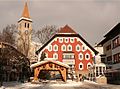
 Saalfelden town hall |
||
| Source: Municipal data from Statistics Austria | ||

Saalfelden am Steinernen Meer is a city in the Austrian state of Salzburg and is the central place of the Pinzgau Saalach Valley . The community is located around 14 km north of the district capital, Zell am See . With 16,705 inhabitants (as of January 1, 2020), Saalfelden is the most populous city in the Zell am See district and, after Salzburg and Hallein, the city with the third highest population in the state of Salzburg.
geography

Saalfelden am Steinernen Meer is 748 m above sea level and covers 118 km².
The Saalfeldner basin , which is embedded in between , takes up the largest part of the community area
- the Stone Sea in the north
- the Leoganger Steinberge and the Biberg in the west
- as well as the Hochkönig massif and the Dientener mountains in the east.
Towards the south, the basin is broadly open towards the Zeller basin of the Zeller See and the Salzach and allows a view of the Hohe Tauern , in particular the Kitzsteinhorn and Wiesbachhorn . The two basins are separated by a valley watershed that is hardly recognizable from the landscape . This valley is one of the largest inner-alpine basins .
The main river of the basin is the Saalach. This rises in the rear Glemmtal , enters the basin south of Saalfelden and flows through it from south to north. The right tributary of the Saalach, which flows through the city of Saalfeld in an east-west direction, is the Urslau, and the Leoganger Ache flows into the Saalach as a left tributary coming from the west . There are also some smaller tributaries.
In the middle of the basin is the 100 m high elevation of the Kühbichl (Kühbühel).
The only lake in the extensive basin is the artificially created Ritzensee, which is used for recreational purposes . Several other, also man-made ponds are primarily used for fishing and tourism.
Community structure
The Saalfeldner basin was more or less heavily populated as early as the Bronze Age and also after the arrival of Bavarian immigrants. A settlement or locality at that time cannot be imagined in the same dimension as villages or places present themselves today. A single farm consisting of a stable, barn and house is to be counted for a locality at that time. This explains why many places formed in the Saalfeldner Becken, in the Saalfeld .
In the course of time, Saalfelden developed into a central location; the small, surrounding villages were incorporated and are now part of the urban area. Some of them have already grown so closely with the urban area that they are no longer recognizable as once separate settlements. These 35 now incorporated localities are (population in brackets as of January 1, 2020):
- Almdorf (129)
- Bachwinkl (418)
- Breitenbergham (175)
- Bsuch (880)
- Deuting (10)
- Dorfheim (743)
- Euring (189)
- Gerling (53)
- Haid (544)
- Harham (218)
- Courtyard (52)
- Hollow roads (50)
- Kehlbach (212)
- Lenzing (635)
- Letting (123)
- Marzon (53)
- Mayrhofen (36)
- Niederhaus (92)
- Obsmarkt (303)
- Pabing (405)
- Pfaffenhofen (59)
- Pfaffing (118)
- Rain (32)
- Ramseiden (818)
- Ruhgassing (64)
- Saalfelden am Steinernen Meer (8585)
- Ham (260)
- Schmalenbergham (56)
- Blacksmithing (29)
- Schützing (31)
- Thor (526)
- Uttenhofen (182)
- Weikersbach (97)
- Wiesersberg (337)
- Wiesing (191)
The city of Saalfelden comprises nine cadastral communities :
- 57104 Bergham
- 57106 Farmach
- 57107 Gerling
- 57110 Haid
- 57113 ravines
- 57114 Lenzing
- 57116 Lichtenberg
- 57122 Saalfelden
- 57129 Uttenhofen
Neighboring communities
The neighboring communities of Saalfelden are:
| Weißbach near Lofer | Weißbach near Lofer | Schoenau upon Kings sea |
| Leogang |
.svg)
|
Maria Alm at the Stone Sea |
| Maishofen and Viehhofen |
Maishofen and Zell am See |
Maria Alm at the Stone Sea |
The municipality of Schönau am Königssee, in the northeast of Saalfelden, is in the Bavarian district of Berchtesgadener Land .
history
- Early history and antiquity
The first finds in the Saalfeldner basin date from the 3rd millennium BC. The stone ax with a drilled handle hole, excavated in 1891, dates from this epoch ( Neolithic Age ) , but its location has not been recorded or passed on. Copper deposits were sufficiently available in this region for the time and corresponding mining sites can still be proven today.
There are hardly any finds from the following older Iron Age , which suggests that settlement in the Saalfeld area declined. Only in the younger Iron Age (2nd to 1st century BC) did a strong increase in settlement become evident. At that time the Celts settled in Pinzgau. The famous "Hirsch vom Biberg", a bronze sculpture in the form of a sitting stag, dates from this era. According to the latest findings, the place of its manufacture does not necessarily have to coincide with the place of discovery. But one is certain that the work comes from the zone north of the Alps .
Very little has come down to us from Roman times. Only names and designations suggest a strong influence of Roman culture. Names like Bisontio (from which Pinzgau is derived) or Marcon (today's Marzon ) probably come from this era.
- middle Ages
From the 7th century, Bavarian immigrants took possession of the Saalfeld basin. The place name endings -ing or -ham prove the early conquest of the land by this ethnic group. As a result, the Romansh population was mixed with the Bavarians. It is noticeable that the naming of places or bodies of water in the valley floor increasingly suggests Bavarian settlement, whereas the Romance expressions occur more often on the edge of the Alps or the basin.
The oldest inventory of goods in the Salzburg church was created in the 8th century . With these notes, the importance of the Salzburg founder saint Rupert as Apostle of Bavaria was documented. This list of goods also brings the first written message about Saalfelden and the Pinzgau . It reports that a priest by the name of Boso had handed over certain lands in places in the "Salzburggau" (Saalfelden, Zell am See, Wals ). Saalfelden is named, as is the river Saalach : "in Bisoncio, quod nunc Pinzgo dictur atque ad Salvet super Sala" ("in Bisoncium, which is now called Pinzgau, as well as to Saalfelden an der Saalach").
Later, Bavaria was incorporated into the " Franconian Empire " and the Franconian county constitution was introduced. Two counties were established in Pinzgau, of which the county in Oberpinzgau corresponded to the current judicial district of Mittersill and the county of Mitter- and Unterpinzgau comprised the remaining part of today's political district of Zell am See.
For the year 930 it is said that a certain Count Dietmar had possessions in Saalfelden. His (probable) son, the noble Dietmar, handed over the lands in and around Saalfelden to Archbishop Hartwig (991-1023) in an exchange transaction. This laid the foundation stone that enabled Saalfeld's development into a place and market.
The 11th and 12th centuries can be described as the time of the " Lords of Saalfelden ".
In 1228 Archbishop Eberhard II (1200–1246) acquired what is now Pinzgau through an exchange deal with Bavaria. In the handover certificate, Saalfelden was still mentioned as a separate basin landscape, the Salfeld , and not as a place. In 1290 Gebhard von Felben lost Lichtenberg Castle to the archbishop and an archbishopric district court in Saalfelden was formed in 1294 .
Around the middle of the 14th century, Saalfelden was first mentioned as a market town . In 1418 the Saalfelden Regional Court was merged with the administration of Lichtenberg Castle and the Lichtenberg Care Court was subordinated to the keeper (administrator) of the castle.
- Modern times
The rest of the story is very much connected with the Church. The Witch Mania , the belief in the devil's pact and in sorcery, also reached the Pinzgau towards the end of the 16th century . One of the first tortures in Saalfelden was the burning of an alleged sorceress in 1565. The focus of the witch hunt in the Pinzgau then shifted to the Mittersill nursing court . These persecutions lasted well into the 18th century.
As a result, Saalfelden became a rebellious community. As early as 1801, after the last reigning Archbishop of Salzburg had gone into exile in Vienna, the Saalfeldner farmers had refused to pay the usual stock rights and forest money from their wood purchase, pointing to the lack of a sovereign . In 1811 it is reported that only 300 guilders were paid out of a claim of 1000 guilders .
From the 17th to the 19th century, as a market town, Saalfelden experienced a long recession in its economic development. The trade routes had changed. The main trade now ran via the Pongau and Lungau to the archbishop's residence city of Salzburg. The market days, which dates back to the 14th century, became increasingly important. Tuesday was set as the market day for Saalfelden.
- 19th century
During the Napoleonic Wars , there was extensive self-government in community matters.
In 1811 a fire destroyed the entire market, in which 107 houses and the church were reduced to rubble and ashes in just four hours. Over 800 people were left homeless. Donations and relief supplies came from all over Salzburg and also from Bavaria, which made the reconstruction possible. This fire led to the first fire and building codes.
In 1816 Salzburg (and with it also Saalfelden) came back to Austria after six years of belonging to Bavaria again . From 1850 to 1854, Saalfelden was the seat of the district administration . In 1864 the new Salzburg municipal ordinance was passed, including: The foundation of the free state is the free municipality! . Saalfelden was able to benefit from this.
In 1875, Saalfelden received a railway connection with its own train station. This time can also be seen as the birth of the Saalfeld social democracy . As early as 1901, two thirds of the votes cast in a Reichsrat election in Saalfelden were social democratic.
In 1899 the market water pipeline was built. Before that, twelve public wells and 20 private wells had supplied the houses.
- 20th century until today
At the turn of the 20th century it was still common for only one “ citizen ” to hold the office of mayor . The list of Saalfeldner citizens on December 5, 1896 included exactly 63 men.
- 1891–1912 Mayor: Josef Eberhart (1849–1912)
Eberhart led Saalfelden into the 20th century. In the year of his inauguration, the “Sparkasse der Marktgemeinde Saalfelden” was founded on his initiative. He was primarily responsible for building the first aqueduct from the Kalmbach in 1899. In 1905, the construction of an electricity plant began in Bachwinkl. This made it possible to significantly improve the street lighting and displace the oil lights. In 1906 a new school was inaugurated. In 1910, Saalfelden already had 5589 inhabitants. Mayor Eberhart died on February 5, 1912.
- 1912–1919 Mayor: Johann Eiböck (1870–1945)
After the death of his predecessor Johann Eiböck was from the February 16, 1912 town hall meeting elected mayor. The troubles of the First World War shaped the community life at this time, which is proven by numerous minutes of community committee meetings from these years. Saalfelden was plagued by acute housing shortages. The influx of people into the market was much stronger than living space could be created.
During this time, the so-called "Wagner-Hartl property" was acquired and the parish hall was built in its current location. A kind of "building land protection model" was introduced. The municipality sold parts of the property from the acquired property and the buyers had to undertake not to sell them on at a higher price. A kindergarten was also built.
There was great need during the war years. The church work was reduced almost exclusively to the essentials for survival. With the end of the First World War, the Austrian monarchy ended , the First Republic was proclaimed and parliaments were elected everywhere. On April 6, 1919 there were the first state elections in Salzburg.
- 1919–1934 Mayor: Josef Riedler (1873–1965)
The teacher Josef Riedler was the first social democratic mayor of Saalfeld. From 1922 to 1934 he was also a member of the Salzburg state parliament . As a victim of the Austro-Fascist corporate state , he was prevented from entering the municipal office and exercising his function on February 13, 1934. He was also relieved of his office as school director and retired early. One of his hobbies was mineralogy; one of his collections can be seen in the local history museum at Schloss Ritzen .
- 1934–1936 Market municipality and rural municipality Saalfelden were managed separately on a provisional basis.
In 1935, Elise Trauner, who came from Kehlbach near Saalfelden, was murdered in her home town. Soon after, her boyfriend at the time was arrested as the perpetrator, sentenced to death and executed on November 30, 1935 in the courtyard of the Salzburg Regional Court.
- 1936–1938 Mayor: Bartholomäus Fersterer (1882–1949)
The barracks were built in the town during the tenure of Bartholomäus Fersterer. The municipality had to provide the building-ready grounds free of charge. In 1937 there were 6570 inhabitants in Saalfelden.
On April 10, 1938, Saalfelden also voted with an overwhelming “yes” to join Hitler's Germany (officially 99.03%). This result was questioned in the same year. Nevertheless, the voting result corresponded to the overall Austrian trend. The proportion of NSDAP members in the population rose rapidly. Mayor Fersterer was removed from office in 1938 in the same undemocratic way that Riedler had to experience in 1934.
- 1938–1945 Mayor: Hans Grosslercher (1896–1994)
On March 18, 1938, Hans Großlercher was appointed acting mayor by the governor . The community was run according to Nazi guidelines and resistance to it could mean prison.
During this time, too, the lack of living space was probably Saalfeld's most pressing problem.
On April 27, 1945, the restoration of the (Second) Republic of Austria was proclaimed under State Chancellor Karl Renner . This enabled the SPÖ workers' party to regroup. The Austrian People's Party emerged from the Christian-social camp and provided the first mayor of Saalfeld in the Second Republic .
- 1945–1949 Mayor: Raimund Rohrmoser (1901–1977)
After the end of the Second World War in 1945, Salzburg belonged to the US-American zone of occupation in occupied post-war Austria . Raimund Rohrmoser had put a heavy burden on himself as mayor. Although he did well with the occupying forces, he was unable to meet the expectations of the population. During his tenure, the US military administration set up a camp to accommodate former concentration camp inmates and forced laborers . When Rohrmoser carried out dubious real estate deals solely for his own benefit, he was voted out of office in the municipal council elections on October 30, 1949. For the first time, the SPÖ won the majority of votes in Saalfelden.
- 1949–1972 Mayor: Adam Pichler (1907–1989)
Saalfelden had a lot of catching up to do in all areas of public life. The road network and the water supply had to be expanded. The construction of the Urslau began and the central building yard was set up.
Much progress has been made in the housing sector. Above all, the housing cooperatives “Heimat Österreich” and “Bergland” built many rental and owner-occupied residential buildings. Due to the expansion of the living space there was also a need for more schools, which were subsequently built.
After the Americans left, the BEA (Federal Education Institute) moved into the former occupation apartments in Bürgerau. The name of the school then changed to HIB (Higher Boarding School of the Federal Government) and finally to the Bundesgymnasium and Sportrealgymnasium HIB Saalfelden . Saalfelden became a school center.
In 1971 there were 10,175 inhabitants in the market town.
- 1972–1978 Mayor: Karl Reinthaler (1913–2000)
For health reasons, the SPÖ member Karl Reinthaler only served six years as mayor. Reinthaler was persecuted by the Gestapo and a political prisoner between 1942 and 1945. As a contemporary witness he often told of the events.
Under his leadership, the construction of the Bergland-Siedlung began and the schools HTL and HBLA Saalfelden were founded. Two wholesale markets (Interspar and Konsum ) were built and the Obsmarktbad was completely redesigned.
- 1978–1996 Mayor: Walter Schwaiger (1935–2012)
The social democrat Schwaiger took over the office in 1978 from his predecessor and only had to stand for an election in 1979. During his time, the establishment of the rehabilitation center of the pension insurance institution, the construction of the ballroom, the construction of the pedestrian zone, the construction of the gymnasium in the secondary school in Markt, the construction of new kindergartens and the ring water pipe as well as the elimination of garbage and sewage problems through the establishment of the ZEMKA and the Reinhaltverband Mittleres Saalachtal. The volunteer fire brigade got a new, modern training facility and the building for the general special school was built.
The ski jump in the Uttenhofen district was built and in 1988 Saalfelden became the venue for the Nordic Junior World Championships. With the settlement of the PKL (today SIG Combibloc ), an industrial lead company could be won for the place.

- 1996–2013 Mayor: Günter Schied (1956–)
Schied was also a Social Democrat and took over the mayor's office from his predecessor during a legislative period, and he too was impressively confirmed in the subsequent elections.
Saalfeld's development continued unabated. In addition to school extensions and new buildings, the “Kunsthaus Nexus” was built. In his tenure, the fall of town in Saalfelden in 2000. With a budget of 7 million euros in 2005 who established in 1980 the ballroom renovated and converted into a modern conference center. Most of the road network was renovated and other major projects were being planned, such as the construction of a sports stadium and a north-south bypass. The relocation of the building yard from the city center has also begun.
In 2002 and 2005 the Saalfelden area was hit by violent storms. The consequences were floods and devastation. The Urslau in particular brought with it a lot of water and debris and the stream bed was filled with a 1 to 1.5 meter high layer of gravel. The dredging between Grünhäuslsiedlung and Rösslbrücke in autumn 2005 took months.
- 2013-present Mayor: Erich Rohrmoser
coat of arms
Blazon : "In the golden sign on green Dreienberg three green poplar similar deciduous trees (sallow), which is medium higher than the outer two."
Population development
The number of people living in Saalfelden has almost quintupled over the past 150 years.

politics
The community council has a total of 25 members.
- With the municipal council and mayoral elections in Salzburg in 2004, the municipal council had the following distribution: 15 SPÖ, 6 ÖVP, 2 GRÜNE, and 2 FPÖ.
- With the municipal council and mayoral elections in Salzburg in 2009 , the municipal council had the following distribution: 13 SPÖ, 7 ÖVP, 3 FPÖ, and 2 GRÜNE.
- With the municipal council and mayoral elections in Salzburg in 2014 , the municipal council had the following distribution: 12 SPÖ, 7 ÖVP, 3 GRÜNE, and 3 FPÖ.
- With the municipal council and mayoral elections in Salzburg in 2019 , the municipal council has the following distribution: 12 SPÖ, 9 ÖVP, 3 GRÜNE, and 1 FPÖ.
- mayor
- 1891–1912 Josef Eberhart (1849–1912)
- 1912–1919 Johann Eiböck (1870–1945)
- 1919–1934 Josef Riedler (1873–1965)
- 1934–1936 Market municipality and rural municipality Saalfelden were managed separately on a provisional basis
- 1936–1938 Bartholomäus Fersterer (1882–1949)
- 1938–1945 Hans Grosslercher (1896–1994)
- 1945–1949 Raimund Rohrmoser (1901–1977)
- 1949–1972 Adam Pichler (1907–1988) (SPÖ)
- 1972–1978 Karl Reinthaler (1913–2000) (SPÖ)
- 1978–1996 Walter Schwaiger (1935–2012) (SPÖ)
- 1996-2013 Günter Schied (* 1956) (SPÖ)
- since 2013 Erich Rohrmoser (SPÖ)
Town twinning
The city of Saalfelden currently has three city partnerships. A partnership with the city of Rankoshi on the Japanese island of Hokkaido has existed since 1969 . In 1976 a partnership was entered into with the Hessian town of Ober-Roden, which was incorporated into the municipality of Rödermark a year later . The "Ober-Roden-Straße" is named after the place. The third twin town has been the Belgian town of Grimbergen from the Flemish region since 1996 .
Culture and sights


A church in Saalfeld already existed around the year 1000. According to tradition, the noble Dietmar exchanged "his church near Saalfelden" with the church at Palmberg in Bavaria with Archbishop Hartwig (991-1023) . In the 11th or 12th century, parish institutes were set up in the diocese of Salzburg ; in addition to Sankt Martin bei Lofer , Stuhlfelden , Piesendorf and Taxenbach also in Saalfelden. Evidently there was also significant influence from the Chiemsee diocese in the parish of Saalfelden.
- Deanery parish church in Saalfelden : The Catholic church has certainly emerged from the own church of the noble Dietmar. When Saalfelden became a parish, the building, which was once made of wood, is likely to have been further developed and transformed into a Romanesque church made of stone. Filial churches in Maria Alm, Dienten , Gerling and Leogang have been handed down. During restoration work in 1966, the finds made it possible to backdate the original church to the Romanesque period. At that time it was also found out that the west-facing tower was only added to the nave in the Gothic period. The church was increasingly "Gothicized", and it had to be rebuilt repeatedly after two fires. In the period between 1858 and 1861 a general renovation had to be carried out. The church was in a very neglected state. According to plans by the Munich architect Georg Schneider (1828–1897), the church was converted into a neo-Romanesque basilica . The structure of the church has hardly changed over the centuries. Various secular and spiritual personalities contributed to the interior design of the basilica. In the 20th century these were mainly dean Franz Kocher (1894–1953), dean Johann Madersbacher († 1980) and dean Josef Raninger (* 1930). The rectory and the crypt were renovated under Raninger . The baptistery got a new baptismal font and the old, Gothic winged altar was restored. The ringing consists of five bells weighing 439 kg to 3,475 kg. The heaviest bell - the so-called homecoming bell - was received by the church on September 4, 1949. This is primarily intended to commemorate the fallen of the Second World War. The very idiosyncratic-looking wooden cross above the high altar , created in the Expressionist style , was made by the Hallein sculptor Jakob Adlhart (1898–1985). It was built in 1959 and inaugurated in 1961.
- Church in Gerling: The village of Gerling is first mentioned in a document around 1330. The church, which is consecrated to St. Gotthard , is mentioned in a document around 1500. On the basis of excavation finds, however, it is believed to have proven that the church must have stood earlier, as these finds refer to the Chiemsee auxiliary bishop Georg Altdorfer († 1495). The church is built in Gothic style, and during renovation work in 1971, a baroque fresco depicting St. Christopher was uncovered in the gable area. The church stands on a small hill on the edge of the valley and the pointed tower towers high and can be seen from afar. Almost nothing is left of the original furnishings. Only a small crucifix above the left side altar has survived. Two small sculptures - Maria and Johannes - were stolen when they were installed in the crypt of the parish church in Saalfeld during the renovation work. A pictorial representation of the Last Judgment on the back wall of the church can hardly be seen. In 2005 the church was renovated and a year later a small organ was installed, which Archbishop Alois Kothgasser inaugurated. The small church is often used for weddings and baptisms.
- Church in Lenzing: Lenzing is one of the fastest growing districts of Saalfeld, which is why the faithful could no longer find a place in the old Lenzing church. In 1970 the construction of a new parish center with a church, parsonage and parish hall began according to the plans of the Saalfeldner architect Georg Aigner. The old church should be included in the building ensemble. However, only part of the planning was implemented. On May 24, 1973, the then Archbishop Karl Berg was only able to dedicate a new church with 350 seats. The interior is decorated with reliefs by the Saalfeldn artist Klaus Moroder with the names “Baptism of Christ”, “Emmaus Scene” and “Resurrection”, as well as cross-way panels by Maishofn artist Leo Gans.
- Evangelical Peace Church: The evangelical parish of Saalfeld can look back on a very eventful past. Already around 1528 one heard from Saalfelden of "sectic beings", as the supporters of the Lutheran idea were called at the beginning . The Archbishop of Salzburg was often told of the evangelical failures, including the fact that they even ate meat during Lent . There were regular persecutions and punishments. The disputes between Catholics and Protestants came to a head and the archbishop rulers tried a new missionary work by the Jesuits . So it happened that around 1732 there was an involuntary emigration of around 2000 people from the Saalfeld area. That was around 30% of the entire population. Around 670 emigrants went to East Prussia , who , according to tradition, were welcomed there. After this wave of emigration, 68 farms stood empty in the Saalfeldner area. But even then there was a general influx of people into the Saalfeldner basin, and so the empty farmsteads could quickly be settled and farmed again. It was not until the 1920s that there were some Protestant families again in Saalfelden. After the Second World War, the number of Protestants in Pinzgau rose rapidly. 1958 the first Protestant parish in Pinzgau was established in Zell am See under Pastor Günter Geißelbrecht . As Saalfelden grew, so did the Protestant community, which led to the laying of the foundation stone for a church of its own in 1964. On May 15, 1966, the construction was completed and the church on Palvenstrasse was inaugurated. In 1993 the Evangelical Parish of Saalfelden broke away from the parish of Zell am See.
- Thorer Chapel: This small chapel stands on Kollingwaldstraße from Ritzensee to Breitenbergham and is brought to Prussia in direct connection with the emigration of around 670 people, mainly from the rural population. According to oral tradition, the Hasling farmer had this chapel built in memory of her emigrated husband. At this point, the emigrating Protestants are said to have said goodbye to their relatives. The chapel was restored only a few years ago, the roof re-covered and the religious motifs on the front were repainted with new colors. Currently, shortly after Easter, there is an annual appeal from the chapel to the Catholic parish church.

- The hermitage on Palven: The idea of hermits is not a Christian thought, its origins go back to pre-Christian times. Nevertheless, the hermitage on Palven in Saalfelden was created out of a purely Christian faith. A portrait of St. George has been venerated in a rock cave above Lichtenberg Castle since around 1560 . This prompted a certain Thomas Pichler - belonging to the Order of Saint Francis - to obtain permission from the archbishopric consortium in Salzburg in 1664 to be allowed to settle as a hermit above Lichtenberg Castle . With the help of his co-religionists, he built a small on Palven hermitage and built the cave with the image of Saint George on a chapel. Brother Thomas was a hermit on the Palven for 35 years. He was followed by other hermits, some of whom made some alterations and extensions. Today the hermitage is no longer exclusively a Christian place of worship, but also a popular excursion destination for locals and tourists. Today's hermits serve drinks in the summer months to supplement their modest cash registers. Every year on April 23rd, St. George's Day, a fair takes place at Palven.
- Serbian Orthodox Church Saalfelden : The church was consecrated in 2009.
town hall
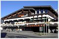
Ballroom from 1980 to 2005

Market secondary school around 1915

Rehabilitation center of the pension insurance company, built in 1979


- Cultural events

The cultural development of Saalfeld is primarily supported by the many small and large associations. The flagship was the Saalfelden International Jazz Festival until 2004, which had to be discontinued in its current form after more than 20 years for financial reasons. After a forced break for one year, the festival was able to restart in 2006. In order to integrate the local population more, the expensive tent city in the Ramseiden district has been abandoned and the festival has been relocated to the city center. The modern Congress Saalfelden now represents the main stage of this series of events and so-called Short Cuts , a series of short concerts carried out by young musicians and avant-garde projects, take place in the Kunsthaus Nexus . The town hall square is named City Stage for the festival . Both here and on the surrounding alpine pastures (such as the Steinalm and the Berggasthof Huggenberg) and in the Alte Schmiede there are concerts without admission fees. The resumption of the festival, especially the reorientation in the city, was received very positively by musicians, visitors and locals alike.
With the Kunsthaus Nexus , Saalfelden built a central building that is important for all those involved in culture in 2001/02. Theater performances, concerts and film screenings for children and young people take place here.
A local museum is housed in Ritzen Castle on the Ritzensee. In 2003 it received the Austrian Museum Seal of Approval and in 2005 the State Award Salzburg Museum Key .
There are two brass bands in Saalfelden. The Saalfelden Citizen Music, founded in 1872, is considered to be one of the best brass bands in the province of Salzburg. A member of the association, Christoph Blatzer, was once world champion and once vice world champion at harmonica world championships. The town band has also been over 100 years ago as a railway workers' Brass Band founded and was the home of all non-bourgeois musicians. Both associations present themselves in concerts throughout the year and support regionally important public and private events.
tourism
In addition to trade and commerce, tourism is the most important economic factor in Saalfelden. A merger with the tourism association of the neighboring town of Leogang created the Saalfelden Leogang holiday region from 1999 onwards .

There is a wide range of options for both winter and summer tourism. The most important attraction in winter is the Skicircus Saalbach-Hinterglemm / Leogang / Fieberbrunn , which, with a total of 270 km of slopes, is one of the largest directly connected ski areas in Austria.
In addition to alpine winter sports, cross-country skiing plays a major role in Saalfelden. Aided by the flat basin landscape, around 80 km, together with those of the neighboring towns, around 150 km of cross-country trails were created. In the area around the Ritzensee there is an artificially snow-covered, in the evening illuminated and World Cup-compatible trail with a cross-country skiing stadium. There is also a local recreation area, the Kühbichl .
Hiking, cycling and mountain biking are the most important fields of activity in alpine summer tourism. A total of 400 km of signposted hiking and cycling trails are available. In addition, the Bikepark Leogang was built in 2002 in the neighboring town of Leogang , where the UCI Mountain Bike World Cup competitions are also held.
traffic
- Rail: Saalfelden is located on the Salzburg-Tiroler Bahn and has had its own train station since 1875, which has become increasingly larger and more important due to the large basic reserves, but also because of the loading options for magnesite mining in the nearby Tyrolean community of Hochfilzen . The Salzburg-Tiroler-Bahn is the only inner-Austrian east-west connection of the Austrian rail network. As an express train station, Saalfelden train station is also important for passenger transport to the surrounding communities.
- Bus: Saalfelden can also be reached in the Salzburger Verkehrsverbund by post buses . The Saalfelden city bus is operated with three lines as an inner-city local means of transport .
- Street: Saalfelden does not have an expressway connection. However, two important east-west and north-south road connections cross in the municipality. The Pinzgauer Straße B 311 leads north to Lofer and turns into the Loferer Straße B 178, on which you can continue in the direction of Bavaria and via the Small German Corner into the state capital Salzburg . Pinzgauer Straße leads south to Zell am See and on towards Pongau . The road is also important for the connection to Oberpinzgau .
- The Hochkönig Straße B 164 leads west to Leogang and further towards Tyrol and east to Maria Alm, Dienten and further towards Pongau.
sport and freetime
- Ritzensee: The Ritzensee and the adjacent Kollingwald are the local recreation areas for Saalfeld's population. The lake is used as a natural swimming pool in summer and for ice skating in winter.
- Hiking trails: Walking and hiking trails are available as cross-country ski trails in winter . In the Uttenhofen district there are also several ski jumps , the Felix Gottwald ski jumping stadium and a center for Nordic combined . Saalfelden achieved fame in cross-country skiing and biathlon sport through its top athletes Felix Gottwald , Simon Eder , Julian Eberhard and Tobias Eberhard .
- The Nordic Junior World Ski Championships have already taken place twice ( 1988 and 1999 ) in Saalfelden .
- Urslautal golf course: The Urslautal golf course is in the Schinking district (towards Maria Alm), and the Brandlhof golf course towards Lofer.
- Triathlon: An international triathlon competition, the Tri-Motion Austria , has been held in Saalfelden every August since 2006 .
Personalities
- Born in Saalfelden am Steinernen Meer
- Joseph Angerer (1735–1779), sculptor
- Alfred Bäck (1903–1974), Mayor of the City of Salzburg
- Laura Feiersinger (* 1993), soccer player
- Wolfgang Feiersinger (* 1965), national soccer player
- Gerhard Fellner (* 1970), soccer player
- Julian Eberhard (* 1986), biathlete
- Tobias Eberhard (* 1985), biathlete
- Ingram Hartinger (* 1949), writer, psychologist and psychotherapist
- Ludwig Hartinger (* 1952), poet, lecturer, editor, publicist and translator
- Josef Hörl (1928–2017), farmer and politician (ÖVP)
- Kathi Hörl (1936–2017), ski racer
- Thomas Hörl (* 1981), ski jumper
- Wolfgang Hörl (* 1983), ski racer
- Mario Lohninger (* 1973), chef, awarded one star in the Michelin Guide
- Hans Mayer (1898–1966), politician (SPÖ) and security director for Vorarlberg
- Alois Persterer (1909–1945), SS-Obersturmbannführer
- William Rea (* 1952), long jumper
- Alexander Schläffer (1899–1984), nativity scene carver
- Melanie Schober (* 1985), comic artist
- Stefan Schwab (* 1990), soccer player
- Barbara Schwarz (* 1959), politician
- Reinhard Schwarzenberger (* 1977), ski jumper
- Franz Zorn (* 1970), speedway driver (ice speedway European champion 2008)
- People related to the city
- Eduard Baar-Baarenfels (1885–1967), Vice Chancellor of the Republic of Austria, died in Saalfelden
- Toni Mark (1934–1959), ski racer, lived in Saalfelden
- Karl Reinthaler (1913–2000), politician and mayor of Saalfelden
- Marlies Schild (* 1981), ski racer, lives in Saalfelden
- Wolfgang Ablinger-Sperrhacke (* 1967), international opera singer, character tenor , grew up in Saalfelden
literature
- Chronicle of the community of Saalfelden , Saalfelden 1992.
Web links
- Community website
- Tourist board website
- Website of the parish of Saalfelden
- 50619 - Saalfelden am Steinernen Meer. Community data, Statistics Austria .
- Saalfelden . In: Salzburger Nachrichten : Salzburgwiki .
Individual evidence
- ↑ Statistics Austria: Population on January 1st, 2020 by locality (area status on January 1st, 2020) , ( CSV )
- ^ Chronicle of Saalfelden, Volume 1.
- ↑ Walter Schwaiger . In: Salzburger Nachrichten : Salzburgwiki .
- ↑ Günter Schied . In: Salzburger Nachrichten : Salzburgwiki .
- ↑ Erich Rohrmoser . In: Salzburger Nachrichten : Salzburgwiki .
- ^ Sister cities of the city of Saalfelden am Steinernen Meer. Retrieved June 13, 2019 .
- ↑ Ski vacation in Austria | Skicircus Saalbach Hinterglemm ,. Retrieved September 27, 2018 .

Bramberg | Bruck | Served | Fusch | Hollersbach | Kaprun | Krimml | Lend | Leogang | Lofer | Maishofen | Maria Alm | Mittersill | Neukirchen | Niedernsill | Piesendorf | Rauris | Saalbach-Hinterglemm | Saalfelden | St. Martin | Stuhlfelden | Taxenbach | Toads | Uttendorf | Viehhofen | Forest | Weissbach | Zell am See