
Dienten mountains
| Dienten mountains | |
|---|---|
 Dientner Mountains and Berchtesgaden Alps , from above the main Alpine ridge (in front of Gastein Valley and the mountain ranges to Rauris Valley and Grossarl Valley ) |
|
| Highest peak | Hundstein ( 2117 m above sea level ) |
| location | Salzburg |
| part of | Salzburg Slate Alps ; Northern Alps or Central Alps |
| Classification according to | Trimmel 1420 Dientner Mountains |
| Coordinates | 47 ° 20 ' N , 12 ° 55' E |
| Type | Inner alpine low mountain range (grass mountains) |
| rock | Grauwackenzone / Werfener layers ( Slate Alps ) |
| Age of the rock | Paleozoic - Lower Triassic (approx. 500–250 mill. A) |
The Dientener Berge , also Dientner Berge , speak without exception "Deant [e] ner Berge", form the main group of the slate Alps in the Salzburgerland . They are bordered to the south and east by the Salzachtal, north by the Schönfeldspitze - Hochkönig line and west by Lake Zell and the Saalfeld basin of the Saalachtal . Orographically they are related to the Berchtesgaden Alps .
For naming
Like other mountain groups in the area, the group is named after the place that is closest to its center, the village of Dienten am Hochkönig (the names of the Kitzbühel Alps and Berchtesgaden Alps are analogous )
Location and landscape
The mountains are largely forested, but on the heights alpine lawns ( grassy mountains , with a low mountain range character ), and - apart from in the surrounding valleys - do not have a single large settlement. Only on the south-eastern edge is the sun terrace around Goldegg im Pongau forming a small hillside settlement area. The entire valley flank towards the Salzach is also scattered about.
The Dientnertal cuts the mountains in a north-south direction and divides them into two approximate squares.
- The western part has the higher peaks and in some cases exceeds the 2,000-meter mark: Hundstein ( 2117 m above sea level ), Hochkaser ( 2017 m above sea level ) and Schwalbenwand ( 2011 m above sea level ), it is a total Hundstein [stock] (Trimmel No. 1421) called
- The eastern part reaches in the Schneebergkreuz 1938 m above sea level. A. , as well as in three other peaks 1800 meters. It forms the Schneeberg-Hochglockner Group (Trimmel No. 1422)
In the area, the Hochkeil ( 1782 m above sea level ), north of the Mühlbach valley , a foothill of the Hochkönig , as the local mountain of Arthurhaus , is still counted among the grass mountains.
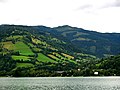
West flank, near Zell am See with Hundstein

Central valley furrow, to the north against Hochkönig and Dienten

Northeast end, at Werfen


tourism
The entire northern roofing of the region is home to local ski areas that are combined to form the Hochkönig's Winterreich, the Ski amadé , of which the one on the northern edge at Arthurhaus and the area around Dienten are the largest, and which then extend to Saalfelden . There is also a smaller ski area on the sun terrace around Goldegg ( Goldegger Buchberg ) .
In addition, the Paul-Ausserleitner-Schanze , one of the four stations of the Four Hills Tournament, can be found on the eastern edge near Bischofshofen .
The interior of the group is hardly developed for tourists and offers delightful, little-frequented high-altitude hikes along the main ridge of the group, the continuation of the high-altitude path to the west beyond Zell am See is the Pinzgauer walk , which is of a similar nature.
The Schwalbenwand is known as the Flugberg .
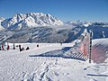
Hochkönig ski region, near Hinterthal (municipality of Maria Alm)

Statzerhaus am Hundstein

Paul-Ausserleitner-Schanze, Bischofshofen


