
Great Wiesbachhorn
| Great Wiesbachhorn | ||
|---|---|---|
 Great Wiesbachhorn |
||
| height | 3564 m above sea level A. | |
| location | Salzburg , Austria | |
| Mountains | Glockner group | |
| Dominance | 9.7 km → Glocknerwand | |
| Notch height | 490 m ↓ Gruberscharte | |
| Coordinates | 47 ° 9 '23 " N , 12 ° 45' 17" O | |
|
||
| rock | Limestone mica schist | |
| First ascent | At the end of the 18th century by the Fusch farmers Zanker and Zorner | |
| Normal way | Kaindlgrat ( I ) | |

The Great Wiesbachhorn is located in the state of Salzburg in Austria and is 3564 m above sea level. A. the second highest mountain range in the Glockner group . The completely free-standing firndome forms the main summit of the Fuscher / Kapruner Kamm and is often seen in alpine literature as a rival to the Grossglockner . The deep fall to the east and south-east has one of the greatest differences in altitude between valley and summit in the Eastern Alps, at over 2400 m . The first ascent of the northwest face on July 15, 1924 by Franz Riegele and Willo Welzenbach was of alpine importance . They used ice hooks for the first time to move on the so-called ice bulge , which were later developed into ice screws . The north-west face was one of the classic ice walls in the Eastern Alps; in the meantime, however, the ice has largely melted.
Location and surroundings
The Great Wiesbachhorn is almost completely surrounded by glaciers . In the north lies the Wielingerkees , in the northeast the Sandbodenkees flows east down into the sandy soil and further into the Fuscher Ache . In the south lies the Teufelsmühlkees and in the west the Kaindlkees . Significant adjacent mountains are in the north, separated by the at 3211 m preferred height sand-lip , the Small Wiesbachhorn with a height of 3283 m . In the southwest, beyond the Wielingerscharte at 3265 m high , between Kaindlkees and Teufelsmühlkees, lie the two viola heads ( 3413 m and 3401 m ). To the west the area falls down to the Mooserboden reservoir , to the east into the Fuscher valley . The nearest significant settlement is Fusch on Großglocknerstrasse, about 10 kilometers as the crow flies in a northerly direction .
Ascents
The original path of the Fuscher farmers at the end of the 18th century, rarely used today, led from Ferleiten to the Schwarzenberghütte in 3½ hours and from there in 4 hours past the Bratschenköpf to the summit of the Horn. Today's starting point for an ascent is the Heinrich-Schwaiger-Haus . From there the normal route leads over the Obere Fochezkopf and the Kaindlgrat to the summit in about 3 hours. In the middle part of the path there is a 35 ° inclined firn cutting edge, the rocky areas are UIAA I difficulty . The classic routes through the 500 meter high north-west face require climbing skills in the ice up to an incline of 60 °.

Wiesbachhorn group, from the north over the Kitzbüheler Horn
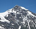
Great Wiesbachhorn

From the summit of the Großer Wiesbachhorn it's over 2,400 meters in altitude to the Fuscher Ache valley


Literature and map
- Willi End : Alpine Club Leader Glockner Group . Bergverlag Rother , Munich 2003, ISBN 3-7633-1266-8 .
- Eduard Richter : The development of the Eastern Alps . III. Volume published by the German and Austrian Alpine Club, Berlin 1894.
- Alpine Club map 1: 25,000, sheet 40, Glockner group .
Individual evidence
- ↑ Height of the reference chart according to the Salzburg Geographic Information System .
- ^ Carl Ehrenbert Freiherr von Moll : Molls Jahrbuch für Berg- und Metallkunde , Volume V, Salzburg 1801, p. 241
- ↑ Federal Office for Metrology and Surveying Austria: Große Wiesbachhorn on the Austrian Map online (Austrian map 1: 50,000) .
- ↑ Eduard Richter: The development of the Eastern Alps , III. Volume, Berlin 1894, pp. 208 ff.
- ↑ Willi End: Alpenvereinsführer Glocknergruppe , Munich 2003, p. 434 ff., Margin no. 1590 ff.