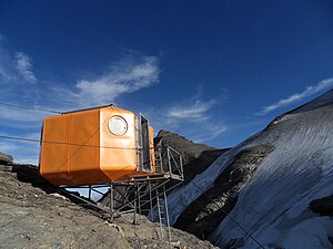
Gruberscharten bivouac
| Gruberscharten bivouac ÖAV bivouac box category I |
||
|---|---|---|
| location | Cultivar notch; Salzburg , Austria | |
| Mountain range | Glockner group | |
| Geographical location: | 47 ° 8 '16.2 " N , 12 ° 43' 59.8" E | |
| Altitude | 3104 m above sea level A. | |
|
|
||
| owner | Austrian Mountain Association of the PES | |
| Built | 1970 | |
| Construction type | Bivouac box ; GRP | |
| accommodation | 0 beds, 9 camps | |
| Web link | Gruberscharten bivouac | |
| Hut directory | ÖAV DAV | |
The Gruberscharten bivouac is a bivouac box on the Gruberscharte in the Glockner Group , the middle part of the Hohe Tauern in Austria . The bivouac is located at 3104 m above sea level. A. above the notch between the Klockerin and the Großer Bärenkopf . The "Poly-Biwak" type bivouac consists of screwed plastic plates made of glass fiber reinforced plastic , was erected in 1970 and is operated by the Austrian Mountain Association of the PES . It is in good condition (summer 2009) and can accommodate nine people.
The bivouac box was only partially usable from June 2013 to July 2014 due to renovation work. The work was carried out by a volunteer team.
The bivouac can be reached from Ferleiten (6½ hours), from the Schwarzenberghütte (2 hours), the Oberwalder Hütte (2½ hours) and the Heinrich-Schwaiger-Haus (3 hours).
Individual evidence
- ↑ Gruberscharten bivouac, Glockner group Gruberscharten bivouac key data / start page. Retrieved October 16, 2017 .
- ↑ Renovation of the Gruberscharten bivouac. Retrieved June 11, 2014 .


