
Fusch on Grossglocknerstrasse
|
Fusch on Grossglocknerstrasse
|
||
|---|---|---|
| coat of arms | Austria map | |
 |
|
|
| Basic data | ||
| Country: | Austria | |
| State : | Salzburg | |
| Political District : | Zell am See | |
| License plate : | ZE | |
| Main town : | Zeller-Fusch | |
| Surface: | 158.05 km² | |
| Coordinates : | 47 ° 13 ′ N , 12 ° 49 ′ E | |
| Height : | 815 m above sea level A. | |
| Residents : | 714 (January 1, 2020) | |
| Population density : | 4.5 inhabitants per km² | |
| Postal code : | 5672 | |
| Area code : | 06546 | |
| Community code : | 5 06 04 | |
| Address of the municipal administration: |
Zeller Fusch 125 5672 Fusch on Grossglocknerstrasse |
|
| Website: | ||
| politics | ||
| Mayor : | Hannes Schernthaner ( ÖVP ) | |
|
Municipal Council : ( 2019 ) (9 members) |
||
| Location of Fusch an der Großglocknerstrasse in the Zell am See district | ||
  |
||
| Source: Municipal data from Statistics Austria | ||

Fusch an der Großglocknerstraße is a municipality with 714 inhabitants (as of January 1, 2020) in the Zell am See (Pinzgau) district in the State of Salzburg in Austria .
geography


The north running Fuscher valley , one of the Tauern valleys, lies north of the main Alpine ridge between the Kaprun valley (in the west) and the Rauris valley (in the east) and is a side valley of the Salzach valley. In the Fuscher Valley, the Fuscher Ache flows north into the Salzach .
From the main Alpine ridge, the Fuscher Ache makes its way north, starting from the source, from the uppermost section of the Fuscher valley - the Käfertal - through Ferleiten and the district of Fusch, until it finally reaches the north in Bruck an der Glocknerstraße 2 km north of the Fuscher municipality flows into the Salzach . The Großglockner High Alpine Road , a well-known panoramic road and popular excursion destination , leads through the Fuscher Valley and Ferleiten , which is located at the end of the valley and also belongs to Fusch .
In a side valley of the Fuscher valley you can find at 1188 m above sea level. A. the Bad Fusch settlement , a high altitude health resort known in the 18th and 19th centuries under the name of St. Wolfgang , which is now in serious decline and is only used as an excursion destination. There are numerous sources here, some of which are said to have healing properties. After Archbishop Friedrich Cardinal Schwarzenberg cured here for the first time in 1829, he promoted the resort. Bad Fusch was one of the most famous mountain health resorts in Austria in the 19th century and could compete with Bad Gastein . However, the place fell into disrepair as a result of the insolvency of the only remaining large hotel after 1945 and today consists only of ruins and a church that was restored in the 1990s.
Large parts of the valley belong to the Hohe Tauern National Park and are therefore subject to particularly strict nature conservation regulations.
- Land and rock slide 2017
On a slope that slipped in 2004 and was then secured with a cost of € 700,000, another slide occurred on February 13, 2017 - triggered by warming after frost - which caused boulders to roll down. Two houses on the slope below are in the danger zone. Since the slope was secured, they were no longer allowed to be permanently inhabited, but only to be visited temporarily. That is now over, now their construction site declaration has been declared expired.
The municipal road to Bad Fusch has also been closed. The regional geologist receives a photo at the same time every day and then assesses the situation. The mayor hopes to be able to reopen the road at the end of the frosty period, which is otherwise typically used by ski tourers and hunters at this time of the year.
Community structure
The municipality includes the following two localities (population in brackets as of January 1, 2020):
- Taxenbacher-Fusch (221) including Ferleiten and Fusch on Glocknerstrasse
- Zeller-Fusch (493) including Bärenwirt, Fusch an der Glocknerstrasse and Judendorf
The community consists of the cadastral community of Fusch.
history
The Fuscher Tal forms the northern end of an old pass path over the Alps, which was already used as a mule track in Celtic times . Celtic and Roman coins were found near the high gate , as well as the highest European sanctuary with a small statue of Hercules. It is not documented whether there was already a village in the valley at this time, but at least accommodation for traders who crossed the main Alpine ridge at the Hochtor is likely. In Fusch itself there are remains of vaults from the Middle Ages. With the medieval mining, a larger number of miners may have come to the valley. However, the most important settlement in the valley has been St. Wolfgang since early modern times, later Bad Fusch, which before the beginning of spa tourism v. a. lived from silver mining on the Kühkarkopf . Today's town center was hardly populated at that time and was probably still partially uninhabitable marshland. The place itself was administratively divided between Taxenbach and Zell am See for a long time , which is reflected to this day in house numbers with the letters Z (for Zeller Fusch) and T (for Taxenbacher Fusch). As an independent community, the place was ruled almost continuously (with the exception of the Nazi era) by Christian social and conservative mayors. The economically remote location benefited greatly from the construction of the Grossglockner High Alpine Road, but outside of the summer months it is still off the main tourist routes.
In society, which had long been dominated by farmers, - as in other rural regions of Austria - forced laborers from Eastern Europe were used by farmers during the Second World War . At the end of the war, several Nazi war criminals sought refuge in the village that belonged to the Alpine fortress that was proclaimed by the Nazi party - but never realized . From 1945 to 1955, the place belonged to the US zone of occupation . The growing tourism since the 1960s brought a certain level of prosperity to the place, which, however, cannot keep up with the large tourist centers in the region and thus saved the place from having to build large ski areas. As in many rural regions of Austria, a certain decline in the rural infrastructure has been observed since the 1990s with the closure of shops, the post office or the gendarmerie. At the same time, the Hohe Tauern National Park and a small related exhibition or the conversion of the Mühlauersäge into a show sawmill provided the first impetus for ecologically and culturally interested tourism.
coat of arms
The blazon of the municipal coat of arms reads: In a green shield a right silver side post , next to it on the left a red armored golden bear .
Population development

politics
The community council has a total of 9 members.
- With the municipal council and mayoral elections in Salzburg in 2004, the municipal council had the following distribution: 6 ÖVP and 3 SPÖ.
- With the municipal council and mayoral elections in Salzburg in 2009 , the municipal council had the following distribution: 5 ÖVP, and 4 SPÖ.
- With the municipal council and mayoral elections in Salzburg in 2014 , the municipal council had the following distribution: 5 ÖVP, 2 FPÖ, and 2 SPÖ.
- With the municipal council and mayoral elections in Salzburg 2019 , the municipal council has the following distribution: 8 ÖVP, and 1 SPÖ.
- mayor
- 1945–1974 Isidor Grießner (ÖVP)
- 1974–1991 Siegfried Embacher (ÖVP)
- 1991–2014 Leonhard Madreiter (ÖVP)
- since 2014 Hannes Schernthaner (ÖVP)
Culture and sights


Little has been preserved of the old structure of the village. The traditional rural architecture can only be seen outside the town center in a few scattered courtyards. The oldest farm is probably the old farmhouse near the Embach chapel between the town center and Ferleiten. In Fusch there is next to the Catholic parish church hll. Aegidius and Martin, of which only the steeple is still preserved as part of the old church, three other historical small Catholic churches or chapels: The Wegkapelle St. Katharina bei Ferleiten, the Hubertus or Wolfgang chapel and the Embach chapel between the town center and Ferleiten. Also worth seeing are the old hotel and spa facilities in the former spa town of Bad Fusch, one of the few 'ghost towns' in the Austrian Alps. In the meantime, the community has built a small Kneipp facility there. The area is suitable for walks and hikes.
Personalities
Honorary citizen
- Siegfried Embacher (* 1928), Mayor of Fusch an der Großglocknerstrasse 1974–1991
- Leonhard Madreiter (* 1944), Mayor of Fusch an der Großglocknerstrasse 1991 - 2014
Sons and daughters of the church
- Gerhard Garstenauer (1925–2016), architect
- Georg Griessner (1948–2011), President of the Salzburg State Parliament
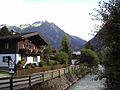
The Fuscher Ache (view in south direction)
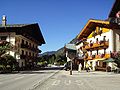
Town center with typical houses
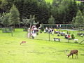
Wildlife Park Ferleiten (to Fusch)

Lower Hirzbach Falls

Nepomuk Grotto on the Nepomuk Path of the Senses


Web links
- Community website
- Article in the SalzburgerLand magazine about Bad Fusch
- Fusch on Grossglocknerstrasse . In: Salzburger Nachrichten : Salzburgwiki .
- 50604 - Fusch an der Großglocknerstrasse. Community data, Statistics Austria .
Individual evidence
- ↑ Fusch: Slipping slope threatens houses orf.at, February 13, 2017, accessed February 13, 2017.
- ↑ Statistics Austria: Population on January 1st, 2020 by locality (area status on January 1st, 2020) , ( CSV )
- ↑ Isidor Grießner . In: Salzburger Nachrichten : Salzburgwiki .
- ^ Siegfried Embacher . In: Salzburger Nachrichten : Salzburgwiki .
- ↑ Leonhard Madreiter . In: Salzburger Nachrichten : Salzburgwiki .
- ↑ Hannes Schernthaner . In: Salzburger Nachrichten : Salzburgwiki .
- ↑ https://www.mein Bezirk.at/pinzgau/c-lokales/fusch-feierte-mit-ehrenbuerger-siegfried-embacher-sehen-90-geburtstag_a2506614 , accessed on April 19, 2019.

Bramberg | Bruck | Served | Fusch | Hollersbach | Kaprun | Krimml | Lend | Leogang | Lofer | Maishofen | Maria Alm | Mittersill | Neukirchen | Niedernsill | Piesendorf | Rauris | Saalbach-Hinterglemm | Saalfelden | St. Martin | Stuhlfelden | Taxenbach | Toads | Uttendorf | Viehhofen | Forest | Weissbach | Zell am See
Salzburg:
Krimml |
Wald im Pinzgau |
Neukirchen am Großvenediger |
Bramberg am Wildkogel |
Hollersbach im Pinzgau |
Mittersill |
Uttendorf |
Kaprun |
Fusch an der Großglocknerstrasse |
Rauris |
Bad Gastein |
Hüttschlag |
Muhr |
Carinthia:
Malta |
Mallnitz |
Obervellach |
Heiligenblut am Großglockner |
Großkirchheim |
Mörtschach |
Winklern |
Tyrol:
Iselsberg-Stronach |
Dölsach |
Nussdorf-Debant |
Kals am Großglockner |
Matrei in East Tyrol |
Virgen |
Prägraten am Großvenediger |
Hopfgarten in Defereggen |
St. Veit in Defereggen |
St. Jakob in Defereggen
(clockwise)