Linz Aach
The Linzer Aach is an approximately 52 kilometers long, northern or right tributary of Lake Constance and thus the Rhine in Linzgau in Baden-Württemberg in Germany .
Names
The Linzer Aach probably originally had the name Linz , which goes back to a Celtic river name Lentia . The Alemannic sub-tribe of the Lentiens and, similar to other rivers, the surrounding landscape Linzgau (an early medieval county) were named after the river.
As set forth below, which today is Linzer Aach called River in its middle reaches and Salem Aach or Rear Aach and in its lower reaches and mouth area Seefeld Aach called.
course
source
The Aach does not spring from a single source; its water comes together from various drainage pipes to form a dole at its source in Herdwanger Ried , a moorland between Herdwangen and Alberweiler in the Sigmaringen district .
Linz Aach
From there it flows through the Ruhestetter Ried nature reserve near Ruhestetten (southern part of the municipality of Wald ) , with its first kilometers running north-east to and through Aach-Linz west-southwest of Pfullendorf . It affects the places Aach in the north and Linz in the south. Then it makes an elongated right curve in order to flow in the opposite direction back through the southern part of Linz. Then running past the small Grimiswald, the Linzer Aach south of Lautenbach, a northeastern part of Herdwangen-Schönach's municipality , takes on the Herdenbach coming from the west, and flows from then on in a predominantly southern direction. At Schönach, the Waschbach, flowing from the southwest, flows into it.
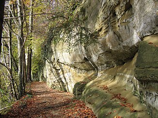
Below Schönach, the Linzer Aach enters the Aachtobel , a steep, wooded valley near Taisersdorf and Hohenbodman (northeastern part of the municipality of Owingen ), which is cut into the soft molasse sandstone by the Aach and is designated as a nature reserve; from the Aachtobel, the Linzer Aach runs in the Lake Constance district . From the observation tower of the Hohenbodman ruin ( 658 m above sea level ), which is just under 200 meters south of Hohenbodman, you can enjoy the view over parts of the ravine between Bruckfelden (western part of the municipality of Frickingen ) in the north and Lippertsreute (north-eastern part of Überlingen ) ends in the south.
Salemer Aach
From these two villages on, the Linzer Aach flows through the Salem Valley . In it, it passes, among other things, the core town of Frickingen and Salem Castle around one and a half kilometers north of Salem, is accompanied by the Stefansfelder Canal , which branches off from the Linzer Aach and meets it again east of Buggensegel, and flows through the core town of the Salem municipality . From here on the river is also called Salemer Aach .
A few hundred meters northeast of the hamlet of Wehhausen (zu Salem), the Deggenhauser Aach, coming from the north, joins the Linzer Aach. Then at Ahausen (western part of the municipality of Bermatingen ), where it is also called Hintere Aach , it makes an elongated curve to the right, finally flowing mainly westwards.
Seefeld Aach
In its lower reaches and the mouth area, also called Seefelder Aach , the Linzer Aach runs to Uhldingen-Mühlhofen , where it runs between the village of Unteruhldingen (southwestern part of the municipality of Uhldingen-Mühlhofen) in the south and the hamlet of Seefelden (western part of the municipality of Uhldingen-Mühlhofen) in the North in the nature reserve Seefelder Aach estuary into the Überlinger See (northwest part of the Obersee of the Bodensee) and thus flows into the Rhine.
level
In Uhldinge is located at flow kilometers 2,350 the level Uhldingen / Seefeld Aach the flood forecasting center Baden-Württemberg and the State Institute for Environment, Measurements and natural Baden-Württemberg (LUBW); The operator is the Tübingen regional council . The level zero point is 397.61 m above sea level. NN , the catchment area covers 271 km².
- Statistical values
| Stand / drain | m | m³ / s |
| Average water level | 0.59 | |
| Lowest water level in 1985–2003 on June 14, 1997 | 0.31 | |
| 50-year high water level / runoff | 2.66 | 67.6 |
| 100-year high water level / runoff | 2.89 | 76.2 |
| Lowest discharge from 1985–2003 on August 28, 2003 | 1.00 | |
| Average runoff | 3.17 |
Watershed
The "source area" of the Linzer Aach lies on the Rhine-Danube watershed , which is part of the main European watershed . The Linzer Aach flows mainly in a southerly direction into Lake Constance and thus over the Rhine into the North Sea; the Kehlbach, which rises a little further north of the headwaters of the Aach, drains mostly in a northerly direction via the Andelsbach and Ablach rivers into the Danube and thus into the Black Sea .
Web links
Individual evidence
- ^ German Hydrological Yearbook Rhine Region, Part I 2009 State Institute for Environment, Measurements and Nature Conservation Baden-Württemberg, p. 75, accessed on January 22, 2016 (PDF, German, 1.85 MB).
- ↑ "Hintere Aach", among other things, according to "DTK50 BW" (dig. Topographic map; see there at the river section at Ahausen (Bermatingen-) Ahausen), but is also only called "Aach" there, and according to "The Great World Atlas "(Bertelsmann; 1992)
- ↑ "Behind Aach" (the missing "e" may be a typo) z. B. according to "The Great Falk Atlas" (2003/04 - Germany / Europe)
- ↑ Information on the website of the Baden-Württemberg flood forecast center , accessed on August 27, 2015

