
Andelsbach (Ablach)
|
Andelsbach older names: Andel, Andelnbach |
||
 Course of the Andelsbach |
||
| Data | ||
| Water code | DE : 11328 | |
| location |
Baden-Württemberg
|
|
| River system | Danube | |
| Drain over | Ablach → Danube → Black Sea | |
| source | at Illwangen -Glashütten 47 ° 49 '42 " N , 9 ° 24' 5" O |
|
| Source height |
801 m above sea level NN source of the Andelsbach |
|
| muzzle | at Krauchenwies coordinates: 48 ° 1 '41 " N , 9 ° 14' 40" E 48 ° 1 '41 " N , 9 ° 14' 40" E |
|
| Mouth height | approx. 578 m above sea level NN | |
| Height difference | approx. 223 m | |
| Bottom slope | approx. 7.5 ‰ | |
| length | 29.7 km from the source of the Andelsbach |
|
| Catchment area | 152.447 km² | |
| Left tributaries | Kehlbach | |
| Flowing lakes | Illmensee , Ruschweiler See | |
The Andelsbach , formerly known as the Andel and Andelsbach called, is a 30 km long river in the district of Sigmaringen in southern Baden-Wuerttemberg , the approximate after Northwest run at Krauchenwies from the right Danube influx Ablach zumündet.
geography
course
The source streams of the Andelsbach arise a little north of Glashütten and the Höchst Mountain ( 838 m above sea level ) in the Illmensee municipality on the southern edge of the Nachtweide forest area . The right upper course Andelsbach, which is regarded as the main course, rises here at about 801 m above sea level. NN , the somewhat longer, but less catchment area, left Seehaldengraben even to about 801 m above sea level. NN . Both run approximately north-north-west through the forest and the subsequent corridor to the district Illwangen , where they then flow together after 1.8 km and 2.1 km respectively. ⊙ Then the Andelsbach feeds at 691.4 m above sea level. NN the 66 hectare Illmensee , after the exit it crosses the eponymous capital of the Illmensee municipality and flows through at Ruschweiler at 691.2 m above sea level. NN the 22 ha large Ruschweiler lake .
On a north-westerly course, after the last hamlet of Gampenhof in the municipality , it crosses the municipal boundary of Pfullendorf , flows past the hamlet of Andelsbach on the left bank and then crosses the first district of Denkingen . Before he would reach Pfullendorf himself in a further north-west run, he bends in a wide floodplain for three kilometers on the north run and thus passes the small town in the neighboring valley, the easternmost parts of which extend to the left ridge of the hill. In a north-north-westerly direction again, it passes the Pfullendorf single houses collectively called Am Andelsbach and flows on between Zell am Andelsbach on the left and Schwäblishausen on the right foot of the slope.
The stream then reaches the district of Krauchenwies , whose first valley village, Hausen am Andelsbach, extends right to the bank. A little below it flows north of Ettisweiler , which is on the ascent to Talsporn, coming from the left and south, at about 589 m above sea level. NN the Kehlbach , with a length of 16 kilometers and a catchment area of 55 square kilometers, the most important tributary. The rest of the course of the small river moves northwards, soon reaching the settlement boundary of Krauchenwies itself and flowing in the village past Krauchenwies Castle through the castle park. Between the railway bridge of the Ablachtalbahn and the town's sewage treatment plant, the Andelsbach flows from the right and south into the Ablach, which runs east-northeast to the Danube .
Catchment area
The Andelsbach drains 152 km² of the glacial moraine landscape to the right of the upper Danube in a north-westerly direction to the Ablach . Its catchment area is roughly the shape of a right-angled triangle, the hypotenuse of which on the northeast side extends from the northern summit of the Höchst south of Illwangen over 25 kilometers to the mouth at Krauchenwies . From there, the short west northwest runs cathetus 14 kilometers into the forest Forest southwest of Rothenlachen about the source of the large left inflow Kehlbach . The larger cathetus from there back to the highest is almost 21 km long and runs about southeast.
Immediately adjacent larger catchment areas are - listed counterclockwise from the northern tip - initially beyond the west-northwestern watershed that of the Ablach itself and in between its tributary Ringgenbach . Then the Linzer Aach drains beyond the southwestern watershed and then its tributary Deggenhauser Aach to Lake Constance ; On this section the European main watershed between the Danube on this side and the Rhine on the other side runs on the border line. This also follows on a first short stretch to the right of the uppermost Andelsbach on the northeast side to about the width of Lake Illmen , here the Rotach , which also flows to Lake Constance, is a direct competitor. On the longest part of this side of the catchment area almost to its northern tip, however, the Ostrach leads the water that falls behind the ridge of the valley directly into the Danube.
The highest point in the catchment area is on the northern tip of the Höchst at 838 m above sea level. NN .
Tributaries and lakes
Hierarchical list of tributaries and ![]() lakes from the source to the mouth, indented below the receiving water and arranged from its origin to its mouth. Length of water, lake area and catchment area and altitude according to the corresponding layers on the LUBW online map. Other sources for the information are noted. Only names of waters that are not bracketed are their proper names.
lakes from the source to the mouth, indented below the receiving water and arranged from its origin to its mouth. Length of water, lake area and catchment area and altitude according to the corresponding layers on the LUBW online map. Other sources for the information are noted. Only names of waters that are not bracketed are their proper names.
Origin of the Andelsbach at about 801 m above sea level. NN about 600 meters north of the water tank and the radio tower on the north crest of the highest 837.8 m above sea level. NN in the Zinken Glashütten belonging to the Illwangen district of Illmensee . The stream first flows northwards into the Nachtweide forest .
- (Waldhangbach), from the left and south to about 750 m above sea level. NN on the first crossing forest path in the night pasture , approx. 0.4 km and approx. 0.1 km². Arises at about 795 m above sea level. NN on the southern edge of the night pasture not far from the main spring. From about here north-northwest run.
- (Waldhangbach), from the right and northeast to about 748 m above sea level. NN little after the previous one, 0.4 km and about 0.1 km². Arises at about 760 m above sea level. NN just on the forest area of the hamlet Höhreute of the community Wilhelmsdorf in the neighboring district of Ravensburg .
- Sacker Graben, from the right and east to about 727 m above sea level. NN in a short hollow forest after the exit into the corridor, 0.5 km and approx. 0.2 km² Arises at about 762 m above sea level. NN west of the single house belonging to Höhreute Sack on the northern edge of the night pasture.
- Seehaldengraben, from the left and south to about 712 m above sea level. NN after crossing under the local Höchststrasse (K 8249) on the edge of Illingen ⊙ , 2.1 km and approx. 1.1 km². (The name branch here is 1.8 km long and has a hardly larger catchment area of approx. 1.2 km².) Arises at about 816 m above sea level. NN east of the Putscherhaus, less than 400 meters southwest of the origin of the main run.
- (Klingenbach), from the left and south-southwest to below 770 m above sea level. NN in the Illwanger forest , 0.6 km and approx. 0.2 km². Arises at about 817 m above sea level. NN north of the Putscherhaus.
- Heidenöschgraben, from the right and east to about 708 m above sea level. NN in the northern Illwangen, approx. 0.9 km and approx. 0.3 km². Arises at around 765 m above sea level. NN in two branches as Raingraben under the Höhreutener Kuppe Greut (approx. 780 m above sea level ).
- Shoulder stream ditch, from the right and east to about 702 m above sea level. NN between Illwangen and the Loretto Chapel at Mariahof, approx. 0.7 km and approx. 0.3 km². Arises at about 760 m above sea level. NN north of the water reservoir on the slope
- Mariahofgraben, from the right
- Slope ditch, from the right and northeast to about 695 m above sea level. NN between Marienhof and the following lake, approx. 0.8 km and approx. 0.3 km². Arises at about 765 m above sea level. NN near the Birkhofer Wäldle . Around this inlet, two left tributaries, up to 400 meters long, lead off from the Andelsbach and also flow into the following lake.
-
 Flows through at 691.4 m above sea level. NN the Illmensee near the main town Illmensee of the municipality, 66.2 ha. Two up to 0.6 km long drainage ditches from the Gewann Ob Ried flow into the western bay of the lake between Reute in the south and the town of Illmensee itself in the north .
 - Seewiesengraben , from the left on the southern edge of Illmensee.
- (Drainage ditches from the reed ), from right and left north of Illmensee, up to 0.8 km.
-
Flows through at 691.2 m above sea level. NN the Ruschweiler lake on the southern edge of Ruschweiler , 22.1 ha. Then west run.
- Öschlegraben, from the left and south a little after the exit from the previous one, 1.3 km and approx. 1.0 km². Arises at about 695 m above sea level. NN in a damp hollow southwest of the Illmenseer industrial park.
-
Flows through at 691.1 m above sea level. NN the Volzer See a few steps before the mouth, 4.3 ha.
-
- Krumbach , from the left and southeast to over 690 m above sea level. NN between Illmensee and the hamlet of Gampenhof von Ruschenweiler on the western edge of the Volzer Hölzles , 4.7 km and 3.3 km². Arises at about 779 m above sea level. NN northwest of Lichtenegg before the forest.
- Hungerberggraben, from the right and northeast to just under 690 m above sea level. NN at Gampenhof, 2.0 km and 1.9 km². Arises at about 735 m above sea level. NN north of a large single farm on Ruschweiler Sturmbergstrasse. Mostly digging in.
-
Drains below 720 m above sea level. NN a small pond in a short hollow forest west of the Hungerberg , under 0.1 ha. As a result, approximately northwest run. From about here the Denkingen district of the city of Pfullendorf extends to the left bank, after a little over two and a half kilometers the Andelsbach flows into this district.
-
-
About 400 meters from the run are the two gravel ponds Denkinger Lakes on the southeast edge of Denkingen at under 675 m above sea level. NN in a 19 hectare former gravel pit in the Kreuzäckern , which is now under nature protection, a total of 1.1 hectares.
- (Inlet of the waterless Malaiental ), from the left and south at the level of Denkendorf, about 2.0 km. The L 201 enters the Andelsbach valley through the Malaiental.
Bend to the north, below 645 m above sea level. NN a good 2 km after the previous one. Shortly thereafter, the L 201 rises above the left edge of the valley. - Mistbärengraben, from the left and south-southwest to about 636 m above sea level. NN in Pfullendorfer Unterried a quarter of a kilometer after crossing under the dam of the Altshausen – Pfullendorf railway line , 1.8 km and 2.6 km². Arises at about 643 m above sea level. NN near the left foot of the slope in the very wide floodplain of the Andelsbach.
- Hardgraben , from the right and east to about 632 m above sea level. NN in the Upper Riedwiesen at the Pfullendorfer art mill, 2.3 km and 8.2 km². Arises at about 641 m above sea level. NN in the Hart in front of the hillside forest Spitz and drains in the south on 136 hectares of protected swamping moor Taubenried , the greater part of which lies on the boundary of the eastern Pfullendorfer neighboring community Ostrach .
- Harbach , from the right and northeast to about 630 m above sea level. NN in the Upper Riedwiesen at the Pfullendorfer Bleiche, 1.9 km and 5.0 km². Arises below 640 m above sea level. NN in the northeast tip of Riedle of the Taubenried nature reserve in the beginning forest. Drains the Taubenried in the north . After this confluence, the Andelsbach flows briefly to the west and is spanned by the bridge of the Pfullendorf – Ostrach state road (L 194).
- → (exit of the canal to the leaf mill), to the left to below 628 m above sea level. NN at Pfullendorfer Riedhof. The Andelsbach runs from here very straight about north-northwest through the Pfullendorfer Middle and Lower Riedwiesen .
- ← (return of the canal to the leaf mill), from the left to about 621 m above sea level. NN at this and a little before the bridge of the state road from Pfullingen to Mengen (L 268), 1.4 km.
- Middle Riedwiesengraben, from the right
-
Feeds at about 614 - 610 m above sea level. NN a chain of over a dozen small ponds on the right of the run in the Zeller Oberried , all of them just under 0.1 ha.
- Mottschießer Graben , from the right and southeast to about 605 m above sea level. NN near Pfullendorfer village Zell am Andelsbach , 4.4 km and 4.8 km². Arises at about 645 m above sea level. NN at a forest path cross in the Alten Hau southeast of the Pfullendorfer village Mottschieß . A little later, the Andelsbach crosses the city limits to the Krauchenwies community .
- → (Canal outlet), to the right to about 597 m above sea level. NN at the sports field in the village of Hausen am Andelsbach .
- ← (Canal return), from the right to almost 595 m above sea level. NN at the north end of Hausen, 0.7 km. On the island formed by the canal and the stream and to the right of the lower canal there are around three dozen small basins, together less than 1 hectare.
- Forest ditch , from the left
- Sennebach, from the right
-
Kehlbach , from the left and south to about 589 m above sea level. NN between the villages of Bittelschieß and Krauchenwies of the Krauchenwies community at the foot of a quarry, 16.0 km and 55.2 km². Arises at about 669 m above sea level. NN southwest of the village of Rothenlachen in the municipality of Wald .
After this largest inflow, the north-north-east soon
tributaries in the article - Fence trench, from the right
- Schwarzer Graben , from the right and south-southwest to about 582 m above sea level. NN in Krauchenwies after the bridge of the industrial track, 1.8 km and approx. 1.0 km². Rises at about 600 m above sea level. NN the Antonsbrunnen a little north of Hausen on the wooded right valley slope and very soon runs as a floodplain.
- Steinertgraben , from the right in Krauchenwies
- Dorfbach , from the right and east to about 582 m above sea level. NN at the beginning of the castle park in Krauchenwies, 1.9 km and approx. 4.1 km². Arises at about 618 m above sea level. NN next to the L 286 from Ostrach after leaving the forest.
-
Feeds at just under 580 m above sea level. NN a pond in the castle park, 1.0 ha.
Mouth of the Andelsbach from the right and south-southeast to about 578 m above sea level. NN after the castle park at the sewage treatment plant of Krauchenwies in the Ablach . The stream is 29.7 km long from its right upper course source and has a catchment area of 152.4 km² behind it.
etymology
The hydronym andal or andel is probably of Celtic origin and may mean " vortex " or "water movement against the bank". It can be compared with the old Occitan word andalhon "water movement". Another example of hydronyms that contain the word andel is the Andelle , a 57 km long river in Normandy .
history
The Postal Bittelschieß was on the Won "Postal", which is divided into the so said front and rear Postal, a hill next to the present national road 456 of Krauchenwies according Pfullendorf demonstrated by archaeological excavations. The castle was located above today's Knaus mill, which had a medieval outwork , and not far from a Celtic ring wall in the northeast corner of the castle stable on the local road to Ablach . The win "Burgstall" rises between 600 and 660 meters above sea level on the left and above the confluence of Kehlbach and Andelsbach. The hill is the gravel deposit of the middle Rhine glacier area. On the right side of the Andelsbach there is another Celtic ring wall in the southwest corner of the "Schlossbühl" valley.
environment
Water quality
On May 2, 2008, a consumption warning was issued for fish in Andelsbach by the Sigmaringen District Office , Consumer Protection and Veterinary Department. The Chemical and Veterinary Investigation Office in Freiburg complained about the high concentration of malachite green in the test samples. On January 26, 2009, fish were again taken from the Andelsbach in the area of the Krauchenwies community and examined. According to the findings of February 9, 2009, these fish are not objectionable with regard to malachite green. Based on these test results, the consumption warning was lifted.
gallery
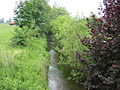
Andelsbach near Hausen am Andelsbach

Andelsbach near Hausen am Andelsbach
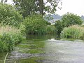
Confluence of the Andelsbach (left) and Kehlbach (right)
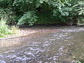
Mouth of the Andelsbach (front) into the Ablach (rear)


Individual evidence
- ↑ a b c Height according to the contour line image on the background layer Topographic map from the online map server of the State Institute for the Environment, Measurements and Nature Conservation Baden-Württemberg (LUBW). See the → web links .
- ↑ a b c Length according to the water network layer ( AWGN ) of the LUBW's online map server. See the → web links .
- ↑ a b catchment area after the layer aggregated areas 05 of the LUBW's online map server.
- ^ Meyers Konversationslexikon, 4th edition, 1885-1892
- ↑ Leopold von Zedlitz-Neukirch: New Hydrographic Lexicon for the German States , 1833, page 21.
- ↑ Lake area according to the layer standing waters of the LUBW's online map server.
- ↑ Catchment area according to the basic catchment area (AWGN) layer of the LUBW's online map server.
- ↑ a b c d e f g Length measured on the background layer of the topographic map of the LUBW's online map server.
- ↑ a b c d e f g h i j k Catchment area measured on the background layer topographic map of the LUBW's online map server.
- ↑ a b c Height according to the blue lettering on the background layer Topographic map of the LUBW's online map server.
- ↑ The Hungerberggraben shows on aerial photos a stretch of over 0.8 km longer than its polygon on the water network layer (AWGN) of the LUBW's online map server with short twisted sections.
- ↑ Brief online description of the Kreuzäcker nature reserve in Denkingen.
- ↑ Valley length measured on the hollow line from the beginning of the open valley floor, above it in the forest for at least another kilometer.
- ↑ Short online description of the Taubenried nature reserve in Ostrach .
- ↑ Catchment area added up from the sub-catchment areas according to the basic catchment area (AWGN) layer of the LUBW's online map server.
- ^ François de Beaurepaire, Les noms des communes et anciennes paroisses de l'Eure , éditions Picard 1981.
- ↑ Removal of the consumption warning . In: Scroll. Bulletin of the Krauchenwies community with the districts Ablach, Bittelschieß, Ettisweiler, Göggingen and Hausen . dated March 6, 2009
literature
- Topographic map 1: 25,000 Baden-Württemberg, as single sheet No. 7921 Sigmaringen, * No. 8020 Meßkirch, No. 8021 Pfullendorf, * No. 8022 Ostrach, No. 8121 Heiligenberg, No. 8122 Wilhelmsdorf (* only for the catchment area)