Rothenlachen
|
Rothenlachen
community forest
|
|
|---|---|
| Coordinates: 47 ° 54 '58 " N , 9 ° 10' 28" E | |
| Height : | 689 m above sea level NN |
| Area : | 2.17 km² |
| Residents : | 43 (December 31, 2014) |
| Population density : | 20 inhabitants / km² |
| Incorporation : | 1st January 1971 |
| Postal code : | 88639 |
| Area code : | 07578 |
|
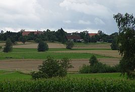
North-east view of Rothenlachen
|
|
Rothenlachen is a suburb of the municipality of Wald in the district of Sigmaringen in Baden-Württemberg , Germany .
geography
Geographical location
Rothenlachen is about five kilometers west of Pfullendorf . The small village is located on a terminal moraine of the Würm glaciation and on the main European watershed . Precipitation in the northern part of the village flows over the Kehlbach , Andelsbach , Ablach and Danube into the Black Sea , while that of the southern part flows over the Linzer Aach into Lake Constance and from there over the Rhine into the North Sea .
Expansion of the area
The total area of the Rothenlachen district is 217.26 hectares (as of December 31, 2014).
history
A pile dwelling colony was discovered near Rothenlachen , which was examined by the Princely Hohenzoller archivist Karl Theodor Zingeler in 1893. In Rothenlachen, in the “Leopoldswald” area, there are two burial mounds of a Celtic clan from Celtic times . Furthermore, a people's castle (ring wall system) is known.
The village was first mentioned in 1224 when it was donated to the Wald monastery . The place was originally in the area of Goldineshuntare , then in Gau Ratoldesbuch and later in the county of Sigmaringen . In the course of the 13th century it passed to the Wald monastery, in 1474 also the lower court and the village rule and at the end of the 16th century local serfdom. In the first half of the 16th century, Rothenlachen formed a judicial and administrative district with the neighboring villages of Riedetsweiler and Ruhestetten . After the destruction of Ruhestetten in the Thirty Years War, the place was considered "half a community".
With the transition of the umbrella bailiwick of the Wald von Hohenzollern-Sigmaringen monastery to Austria in 1783, the place left the county of Sigmaringen. In 1806 the village, like the entire forest territory, fell to the Principality of Hohenzollern-Sigmaringen through the secularization of the monastery due to the Reichsdeputationshauptschluss and in 1850 to Prussia as the Hohenzollern country . From 1806 Rothenlachen belonged to the princely and from 1850 to 1862 to the Prussian Oberamt Wald , since then to the Oberamt and from 1925 to the Sigmaringen district . In the 13th century, lords of Eberhardsweiler, von Ertingen, von Steinfurt and Counts of Nellenburg owned and owned the place .
On January 1, 1971, the previously independent community of Rothenlachen was incorporated into the community of Wald.
Population development
| was standing | Residents |
|---|---|
| Dec 31, 2010 | 38 |
| Dec 31, 2014 | 43 |
politics
coat of arms
In a split shield in front in black a double row of red and silver slanting bars , in back in gold two black plowshares one above the other.
The Cistercian bar is a reminder of the centuries-long rule of the Wald monastery. The two plowshares indicate the agricultural character of the municipality.
Culture and sights
Buildings
- The Marienkapelle is located in Rothenlachen .
Individual evidence
- ↑ a b Rothenlachen on the website of the community of Wald
- ↑ See communications from the Grossherzoglich Badische Landesanstalt. Volume 1. ed. from the Geological State Institute Baden, 1893. p. 49.
- ^ Citizens' protest against gravel mining . In: Südkurier from November 9, 2007
- ↑ Falko Hahn: Gravel pit in the grave hill country . In: Südkurier of October 17, 2007
- ↑ See find reports from Swabia. Volume 2. ed. from the Society for Pre- and Protohistory in Württemberg and Hohenzollern. E. Schweizerbart'sche Verlagbuchhandlung, 1930. p. 17.
- ^ Federal Statistical Office (ed.): Historical municipality directory for the Federal Republic of Germany. Name, border and key number changes in municipalities, counties and administrative districts from May 27, 1970 to December 31, 1982 . W. Kohlhammer, Stuttgart / Mainz 1983, ISBN 3-17-003263-1 , p. 533 .
- ↑ Information from Werner Müller, Mayor of the Wald community, dated January 11, 2011.
literature
- Wald community (ed.): 800 years of forest . Meßkirch 2008, ISBN 978-3-00-023978-6 .
- Walther Genzmer (Ed.): The art monuments of Hohenzollern . tape 2 : Sigmaringen district. W. Speemann, Stuttgart 1948.
Web links
- Rothenlachen on the website of the municipality of Wald


