
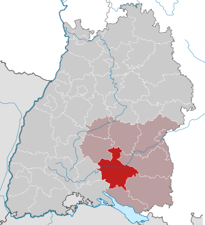
District of Sigmaringen
| coat of arms | Germany map |
|---|---|

|

Coordinates: 48 ° 5 ' N , 9 ° 13' E |
| Basic data | |
| State : | Baden-Württemberg |
| Administrative region : | Tübingen |
| Region : | Lake Constance Upper Swabia |
| Administrative headquarters : | Sigmaringen |
| Area : | 1,204.34 km 2 |
| Residents: | 130,873 (Dec. 31, 2018) |
| Population density : | 109 inhabitants per km 2 |
| License plate : | SIG |
| Circle key : | 08 4 37 |
| NUTS : | DE149 |
| Circle structure: | 25 municipalities |
| Address of the district administration: |
Leopoldstrasse 4 72488 Sigmaringen |
| Website : | |
| District Administrator : | Stefanie Bürkle ( CDU ) |
| Location of the district of Sigmaringen in Baden-Württemberg | |
  |
|
The district of Sigmaringen is located in the south of Baden-Württemberg . The district together with the Lake District and the district of Ravensburg the Upper Swabia region in Swabia .
geography
location
The district of Sigmaringen has shares in the Swabian Alb , Upper Swabia , the Linzgau , the Upper Danube Valley and the Alpine Foreland . The highest point is the Schnaitkapf near Schwenningen at 921 m above sea level. NN , the highest mountain not belonging to the Swabian Alb is 837.8 m above sea level. NN the highest . The lowest point is on the Danube near Herbertingen at 541 m above sea level. NN . The geographic center of the district is the Josefslust wildlife park in the Sigmaringen district. The European main watershed crosses the southern district, south of it drains towards Lake Constance / Rhine, north towards the Danube.
Waters
The watercourses in a circle:
- Ablach (33 km)
- Andelsbach (30 km)
- Danube (60 km)
- Fehla (11 km)
- Kehlbach (16 km)
- Lauchert (44 km)
- Linz Aach (52 km)
- Ostrach (29 km)
- Ringgenbach (6.4 km)
- Schmeie (18 km)
- Schwarzach (from Saulgau 11 km)
Neighboring areas
The district of Sigmaringen borders clockwise in the north, beginning with the districts of Reutlingen , Biberach , Ravensburg , Bodenseekreis , Konstanz , Tuttlingen and Zollernalbkreis .
nature
The district of Sigmaringen has the following 24 nature reserves . According to the protected area statistics of the State Institute for the Environment, Measurements and Nature Conservation Baden-Württemberg (LUBW), 1,966.14 hectares of the district are under nature protection, that is 1.63 percent.
- Blauen : 46.8 ha; City of Sigmaringen - Jungnau district
- Blochinger Ried : 27.8 ha; City of Mengen - District Blochingen
- Blochinger Sandwinkel : 26.6 ha; City of Mengen - District Blochingen
- Booser-Musbacher Ried : 96.4 ha (of which 30.5 ha in the Sigmaringen district); City of Bad Saulgau - Hochberg and Lampertsweiler districts
- Egelsee-Ried : 5.3 ha; City of Pfullendorf - Großstadelhofen district
- Egelsee meadows : 48.0 ha; Community of Wald - districts of Ruhestetten and Rothenlachen
- Fehlatal : 55.2 ha; City of Gammertingen - Gammertingen district, Neufra community - Neufra district, Hettingen city - Hettingen district
- Schwandorf wet meadows : 15.0 ha; Sauldorf municipality - Boll district
- Herdle : 63.9 ha; Neufra municipality - Neufra district
- Kreuzäcker : 19.1 ha; City of Pfullendorf - district of Denkingen
- Kreuzbühl : 4.3 ha; City of Meßkirch - Rohrdorf district
- Morning pasture : 38.5 ha; Inzigkofen municipality - Inzigkofen district
- Ölkofer Ried : 368.9 ha; Hohentengen municipality - Hohentengen and Ölkofen and Herbertingen municipality - Herbertingen municipality
- Pfrunger-Burgweiler Ried : 1,508.1 ha (of which 865 ha in the Sigmaringen district); Ostrach community - Ostrach district
- Ruhestetter Ried : 132.3 ha; Wald community - Ruhestetten district, Herdwangen-Schönach community - Herdwangen district and Pfullendorf district - Aach-Linz district
- Ruschweiler and Volzer See : 70.6 ha; Municipality Illmensee - districts Rusch hamlet and Illmensee
- Sauldorf quarry ponds : 144 hectares (124 hectares of which are in the Sigmaringen district); Sauldorf municipality - Sauldorf district
- Schwackenreuter Baggerseen-Rübelisbach : 104 ha (of which 27.2 ha in the Sigmaringen district); Sauldorf municipality - Sauldorf and Boll districts
- Black moss : 11.0 ha; Ostrach community - Habsthal district
- Taubenried : 136.5 ha; Municipality of Ostrach - districts Burgweiler , Magenbuch and Kalkreute and the city of Pfullendorf - district Pfullendorf
- Lower Au : 20.0 ha; City of Sigmaringen - Laiz district
- Waltere Moor : 97 ha, (23.8 ha of which in the Sigmaringen district); Sauldorf municipality - Sauldorf district
- Wasenried : 11.0 ha; Bingen municipality - Bingen district and Sigmaringen town - Sigmaringen district
- Zielfinger Vogelsee : 45.5 ha; City of Mengen - Rulfingen district and Sigmaringendorf community - Sigmaringendorf district
Land use
49.5 percent of the area of the district is used as agricultural land, around 39 percent is covered with forest. The 46,600 hectares of forest in the district are divided into the following forest owners:
- Municipal forest (39%)
- Large private forest (38%)
- Small private forest (16%)
- Kirchenwald (4%)
- State forest (2%)
- Federal forest (1%)
The 25 community and 63 church forests cover a total of 19,600 hectares, 1,100 hectares of state forest, around 17,000 hectares of large private forest of the former princely houses (Count Douglas / Prince zu Fürstenberg, Hofkammer Altshausen, Fürst von Hohenzollern group of companies - forest and Graeflich Königsegg'sche Betrieb) and 7,900 hectares Private forest of over 6,000 small private forest owners. The forest managed by the federal government is in the restricted military area ( Heuberg military training area ). In the state forest of the district there are 440 hectares of protected forest , which is completely left to itself. Since 1991, the largest contiguous forest area in Baden-Württemberg has been created in Pfrunger-Burgweiler Ried. Protected areas in nature and landscape protection in the district that are of supraregional importance are the " Upper Danube Valley " and the " Pfrunger-Burgweiler Ried ".
The tree species distribution in the Sigmaringen district is as follows:
- Spruce (58%)
- Beech (21%)
- Oak (4%)
- Pine (3%)
- Larch (3%)
- Fir (2%)
- Douglas fir (1%)
- other deciduous trees (6%)
- other conifers (2%)
The wood supply in the Sigmaringen district is 15.5 million cubic meters. Over a year, 500,000 cubic meters of usable wood grow in the forests of the district. Hurricanes like Wiebke (1990) and Lothar (1999) as well as the super summer 2003 led to considerable forest damage in the forest, as a result of which the control of wooden beetles had to be intensified. The district is divided into 19 forest districts, each of which is headed by a district manager.
caves
In the area of the district there are a variety of caves u. a. the Amandahöhle , Bittelschießer Höhle , Burghöhle Dietfurt and Petershöhle .
climate
There are two privately operated weather stations in the Sigmaringen district to collect weather data . A third was operated by the Bundeswehr, but it is no longer connected to a network. The data collected is used by the Meteomedia weather service , among others . A weather station located in the area Sigmaringer Laiz ( position 580 m above sea level. NN ), a second in Pfullendorf ( position 630 m above sea level. NN ).
history
The district of Sigmaringen was created in 1925 through the merger of the two Prussian regional offices Sigmaringen and Gammertingen (see Hohenzollernsche Lande ). After 1945 the district of Sigmaringen was part of the state of Württemberg-Hohenzollern , which was added to the state of Baden-Württemberg in 1952. Since then he has belonged to the administrative district of Südwürttemberg-Hohenzollern and the administrative district of Tübingen . This district formed the southern part of the territorially very fragmented Hohenzollern country; eight exclaves belonged to his area (including Achberg on the Bavarian border), and two places (Warmtal, Burgau) were administered as condominiums with the Saulgau district; See also the section on cities and municipalities before the district reform as well as the article Territorial peculiarities in southwest Germany after 1810 .
The Baden-Württemberg district reform brought about the dissolution of the old district and the establishment of the new district of Sigmaringen on January 1, 1973. In addition to most of the old Sigmaringen district, this includes additional areas in the west, east and south around Meßkirch , Saulgau and Pfullendorf . 30 communities in the Saulgau district , 21 communities in the Stockach district , seven communities in the Überlingen district and the municipality of Bronnen in the Reutlingen district fell to the new Sigmaringen district .
During the district reform (in some cases even before) the exclaves were cleaned up; some by being connected to the main area of the district through the district reform (Beuron, Thalheim), others by changing the district affiliation (Langenenslingen). Some communities far from the district town also fell to other districts between 1969 and 1975 ( Biberach , Konstanz , Ravensburg (Achberg), Reutlingen , Tuttlingen and Zollernalbkreis ).
The municipalities that left or came to the district before or after January 1, 1973 are listed here.
On December 1, 1971, the community Ingelswies was reclassified to the Stockach district .
On January 1, 1972, Storzingen was also awarded to the Stockach district. The city of Trochtelfingen moved to the district of Reutlingen . On February 1, 1972 Egelfingen came to the Saulgau district . On July 1, 1972 Otterswang was reclassified to the Überlingen district .
On May 1, 1973 the districts of Höhreute, Niederweiler and Tafern of the Illmensee community were reclassified to the Wilhelmsdorf community, which belongs to the Ravensburg district .
After the community reform has been completed, the district of Sigmaringen still comprises 25 communities, including 9 towns. There are no large district towns . The largest city in the district is Bad Saulgau , the smallest municipality is Beuron .
Administrative history of the district area

The area of today's Sigmaringen district was divided between numerous lordships until 1802. The center of the district around Sigmaringen and Krauchenwies belonged to the Hohenzollern County of Sigmaringen since 1535 ; the County of Veringen was also Hohenzollern to the north of it. Austrian were u. a. the so-called Danube Cities quantities and Saulgau and the domination Werenwag the west of the county area, Prince bergisch the reigns Jungnau , Meßkirch and Holy Mountain in the north, west and south. Large parts in the east of today's district area belonged to the Fürsteten Grafschaft Scheer ; other worldly territories were u. a. the imperial city of Pfullendorf and the area of the barons of Speth. Ecclesiastical property belonged to the abbeys and monasteries (some of which were under Austrian sovereignty) Salem , Petershausen , Buchau , Wald , Heiligkreuztal , Habsthal , Beuron and Zwiefalten .
Through the Reichsdeputationshauptschluss 1803 and the Rheinbund act 1806, the land was redistributed and then belonged in parts to Baden , Württemberg and the Principality of Hohenzollern-Sigmaringen (which came to Prussia in 1850 ).
On the Baden side, the district offices of Pfullendorf and Überlingen, as well as several civil offices, which were dissolved in the middle of the 19th century, were established. From 1849 there were only the district offices of Meßkirch and Pfullendorf, which were added to the Stockach and Überlingen districts in 1936.
The Oberamt Saulgau was established on the Württemberg side . Some places also belonged to the Oberamt Riedlingen , which was combined with the Oberamt Saulgau to form the Saulgau district in 1938 .
The Hohenzollern regional offices of Achberg , Gammertingen , Ostrach , Sigmaringen , Straßberg , Trochtelfingen and Wald were established in the Hohenzollern area, some of which were dissolved in the course of history. After the transition to Prussia in 1850, only the upper offices of Gammertingen and Sigmaringen existed from 1862, which were combined in 1925 to form the Sigmaringen district.
Population development
The population figures are census results (¹) or official updates from the Baden-Württemberg State Statistical Office (main residences only).
|
|
In 2009, people from a total of 123 countries of origin lived in the Sigmaringen district. The proportion of foreigners was seven percent, another eight percent have a migration background , less than the Baden-Württemberg state average of 26 percent.
In 100 years of migration history , seven waves of migration can be identified for the district. These are the Alpini, forced laborers and soldiers, the displaced, the guest workers from southern Europe, the guest workers and refugees from Turkey , the oriental Christians , the Russian-Germans , as well as the refugees and other immigrants from Africa, Asia and South America. Between 1945 and 1955, the former Hohenzollern Altkreis Sigmaringen was forced under difficult conditions to accept over 6,000 displaced persons , while the Saulgau district took in over 7,000 in their towns and villages. These people came from East Prussia, West Prussia, East Brandenburg, East Pomerania, Silesia, Yugoslavia and Hungary. Extrapolated to today's Sigmaringen district, the displaced persons made up 14.4 percent of the population in 1960, which corresponds to every sixth district resident. On average for the state of Baden-Württemberg of 24.7 percent, this is a rather below-average rate.
In the French occupation zone - the old district of Sigmaringen was one of them - there were 6,000 evacuees from the Ruhr area, Pforzheim and Friedrichshafen after the war. The French occupation zone initially refused to accept displaced persons, but had to bow in 1947 and in the course of the state equalization many displaced persons came to what is now Baden-Württemberg. Some were in Danish camps for two years. Biberach was the transit camp. From there the “refugees”, as they were still lovelessly called by the Upper Swabians at that time, were driven to Sigmaringen. The “resettlement barracks” stood at the Sigmaringen train station for those arriving and were distributed to the surrounding communities; the mayors had to provide living space. Unemployment among the displaced was high; they found jobs on farms as agricultural workers or on construction sites as unskilled workers.
politics
The district is administered by the district council and the district administrator.
District council
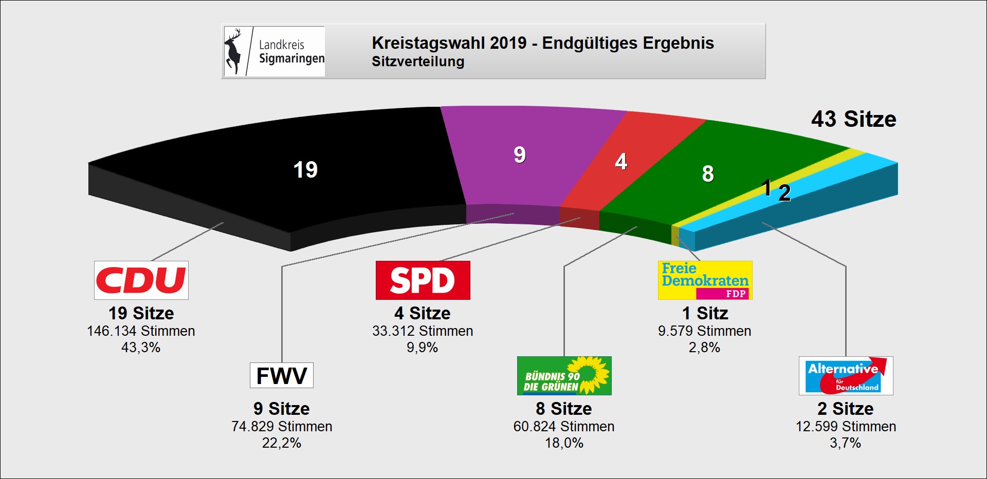
The district council is elected for five years by those entitled to vote in the district. The local elections on May 26, 2019 led to the following final result:
| Parties and constituencies |
% 2019 |
Seats 2019 |
% 2014 |
Seats 2014 |
% 2009 |
Seats 2009 |
% 2004 |
Seats 2004 |
% 1999 |
Seats 1999 |
% 1994 |
Seats 1994 |
% 1989 |
Seats 1989 |
||
| CDU | Christian Democratic Union of Germany | 43.3 | 19th | 52.9 | 22nd | 51.8 | 27 | 52.0 | 26th | 46.5 | 25th | 50.5 | 25th | 47.3 | 21st | |
| FW | Free voters | 22.2 | 9 | 22.9 | 9 | 22.2 | 10 | - | - | - | - | - | - | - | - | |
| Flat share | Electoral associations | - | - | - | - | - | - | 29.3 | 13 | 34.7 | 16 | 25.3 | 12 | 27.1 | 11 | |
| SPD | Social Democratic Party of Germany | 9.9 | 4th | 11.9 | 5 | 11.0 | 5 | 11.5 | 5 | 13.3 | 6th | 14.8 | 7th | 14.7 | 6th | |
| GREEN | Alliance 90 / The Greens | 18.0 | 8th | 10.7 | 5 | 6.8 | 3 | 5.2 | 2 | 2.7 | 1 | 8.0 | 3 | 6.6 | 2 | |
| FDP | Free Democratic Party | 2.8 | 1 | 1.6 | 1 | 3.8 | 1 | - | - | 1.4 | - | - | - | - | - | |
| JL | Boy list | - | - | - | - | 4.4 | 2 | - | - | - | - | - | - | - | - | |
| REP | The Republicans | - | - | - | - | - | - | 2.0 | - | 1.4 | - | 1.3 | - | 4.3 | 1 | |
| AfD | Alternative for Germany | 3.7 | 2 | - | - | - | - | - | - | - | - | - | - | - | - | |
| total | 100.0 | 43 | 100.0 | 42 | 100.0 | 48 | 100.0 | 46 | 100.0 | 48 | 100.0 | 47 | 100.0 | 41 | ||
| voter turnout | 59.7% | 52.1% | 54.0% | 57.0% | 60.2% | 70.7% | 68.9% | |||||||||
- WG: Voter associations, as the results from 1989 to 2004 cannot be broken down into individual groups of voters.
District Administrator
The district council elects the district administrator for a term of eight years. He is the legal representative and representative of the district as well as chairman of the district council and its committees, but has no voting rights in the committees . He heads the district office and is an official of the district. His area of responsibility includes the preparation of the district council meetings and its committees. He calls meetings, chairs them and implements the resolutions passed there. His deputy is the first state official .
The district administrators of the former Saulgau district from 1945 to 1972 are shown in the Saulgau district article .
The Oberamtmen or district administrators of the Oberamt or the district of Sigmaringen since 1807:
- 1807–1817: Karl Honorat von Huber
- 1817–1825: Karl von Schütz
- 1825–1828: Friedrich von Laßberg (son of Joseph von Laßberg )
- 1828–1836: Andreas Franz Kempter
- 1836–1845: Karl von Schütz
- 1845–1850: Carl von Sallwürk
- 1851–1852: Anton von Sallwürk
- 1852–1853: C. Homann (office administrator)
- 1853–1854: Hermann Mock (official administrator)
- 1854–1856: Thaddäus Bachmann (acting)
- 1856–1859: Jakob Franz Hubert Raitz von Frentz
- 1859–1873: Leopold Otto Albrecht von Manstein
- 1873–1883: Hermann Mock
- 1883–1890: Otto von Westhoven
- 1890–1903: Heinrich von Meer
- 1903-1920: Philipp Longard
- 1920–1921: Georg Lang von Langen (as deputy)
- 1921–1923: Anton Reiser
- 1923–1924: Paul Schraermeyer (acting)
- 1924: Carl Alexander Gregor Müller
- 1924–1945: Robert Seifert
- 1945–1967: Ernst Rothenbacher
- 1967–1975: Max Gögler
- 1975–1980: Dietmar Schlee (1980–1992 Minister in Baden-Württemberg)
- 1980–1997: Jürgen Binder
- 1998-2014: Dirk Gaerte
- since 2014: Stefanie Bürkle
District finances
The district finances are quite stable, but suffered a slight slump due to the economic crisis. The 2007 administrative budget concluded with an addition rate of over 6 million euros to the asset budget, and the allocation to the reserve (budget: 0.00 euros) was just under 4 million euros.
coat of arms
The coat of arms of the district of Sigmaringen shows a striding golden deer in red above a humbled silver bar. The coat of arms was awarded on June 9, 1978 by the Baden-Württemberg Ministry of the Interior .
The stag is the coat of arms of the county of Sigmaringen , which has been documented since 1483. The bar is derived from the Austrian coat of arms and symbolizes the earlier affiliation of some areas of the district to Upper Austria .

The Hohenzollern district of Sigmaringen until the district reform in 1972 had a very similar coat of arms, which had been adopted by the district council on October 11, 1954: "A striding golden stag above a red and black shield base in red."
See also: List of coats of arms in the district of Sigmaringen
Economy and Infrastructure
economy
In the Future Atlas 2016 , the Sigmaringen district was ranked 262 out of 402 districts, municipal associations and independent cities in Germany. The district is in last place in Baden-Württemberg and is one of the regions with a "balanced risk-opportunity mix". In the 2019 edition, it was ranked 277 out of 401.
The most important branches of industry in the district of Sigmaringen are mechanical engineering, metal production and processing, wood processing and processing, chemicals and plastics, electrical engineering, leather, textiles and clothing, whereby the economic structure includes traditional craft and family businesses as well as specialist companies specializing in future technologies. There are also service companies and financial institutions. Industrial and commercial focuses are in Bad Saulgau, Pfullendorf, Mengen, Meßkirch, Gammertingen, Sigmaringen, Sigmaringendorf, Ostrach, Krauchenwies and Hettingen.
The district of Sigmaringen has (as of 2009) the lowest wage level in Baden-Württemberg with an average salary of around € 30,300. The national average is around € 36,300. Nevertheless, the district has the highest growth in income millionaires - measured from 2004 to 2007 - in Baden-Württemberg.
Well-known companies based in the district of Sigmaringen:
- AHWI Maschinenbau , Herdwangen-Schönach, manufacturer of agricultural and forestry machines
- Alno , Pfullendorf, kitchen manufacturer
- Claas , Bad Saulgau, manufacturer of harvesting machines
- Columbus , Krauchenwies, the world's oldest globe manufacturer
- Geberit Produktions GmbH, Pfullendorf, European market leader in sanitary technology
- Gmeiner-Verlag , Messkirch, publishing house
- Hohenzollerische Landesbahn , Gammertingen, transport company
- Hohenzollerische Landesbank Kreissparkasse Sigmaringen , Sigmaringen, financial institution
- SRH Kliniken Landkreis Sigmaringen GmbH , Sigmaringen, owner of the three hospitals Sigmaringen, Pfullendorf and Bad Saulgau
- Knoll Maschinenbau , Bad Saulgau, manufacturer of conveying and filter systems as well as pumps
- Kramer , Pfullendorf, construction machinery
- Primion Technology , Stetten am kalten Markt, security technology
- Sparkasse Pfullendorf-Meßkirch , Pfullendorf, financial institution
- Fürst von Hohenzollern group of companies , Sigmaringen, conglomerate with Zollern GmbH & Co. KG, Sigmaringendorf, steel and mechanical engineering
- Vinzenz von Paul GmbH, Sigmaringen, social services and institutions
- Volksbank Bad Saulgau eG, Bad Saulgau, one of the large Volksbanks in Baden-Württemberg
energy
In Herbertingen, the Vorarlberger Illwerke built a large-scale distribution system to supply southern Württemberg and the Rhineland with electrical energy as early as 1929 . The RWE , the main shareholder together with the Zweckverband Oberschwäbische Elektrizitätswerke (OEW), built a new substation for the north-south line here . In 2006 there was a partial update of the 1998 regional plan for Lake Constance and Upper Swabia on the subject of "Renewable Energies". In addition to areas for photovoltaics , this included the communal " Ringgenbach photovoltaic system " on the site of the disused circular waste dump in the Messkirch district of Ringgenbach, the " Neuhaus photovoltaic system " in the Neuhaus district of Stetten, the " EnBW Leibertingen solar park " and the "Inzigkofen photovoltaic system / Pault ”, three locations for wind turbines also designated for the district :“ Judentenberg ”(municipality of Illmensee),“ Storzingen ”(municipality of Stetten am kalten Markt) and“ Inneringen ”(city of Hettingen). The minimum size of the priority areas for regionally important wind power plants is to be dimensioned according to the requirements of the association so that the construction of at least three currently marketable wind power plants, so-called reference plants, is possible at this location. There are already three wind turbines on the Judentenberg. For various reasons, the locations of individual wind turbines such as those in the Mengening district of Blochingen, Schwenningen, on the Bäumlehof near Leibertingen and on the Höchst (near Wilhelmsdorf) will not be expanded. The monastery-owned Danube hydropower plant is located in Beuron . There are also various systems for generating energy from biomass and biogas . With 42 plants, the district is currently (2011) the fourth largest producer of electrical power - behind Biberach, Ulm and Ravensburg. A total of 110,000 MWh of electricity was produced. This could supply 24,400 households with more than two thirds of the residents in the district with electricity. Ten percent of the agricultural area in the district is required for the production of biomass. This currently corresponds to 21 percent of the arable land, in 2007 it was 15 percent. Krauchenwies is the headquarters of a large manufacturer of wood pellets .
armed forces
The Bundeswehr has more than 5,000 civilian and military employees (formerly 11,000 post ) is the largest employer in the district and an important economic factor in rural areas. Around 4600 soldiers and conscripts are stationed at four locations (as of January 2011):
- Oberschwaben-Kaserne Mengen / Hohentengen , Hohentengen: 200 soldiers, around 600 conscripts, 40 civilian employees, founded in 1939.
- Heuberg camp , Alb barracks and Heuberg military training area , Stetten am kalten Markt: 1,800 posts (1,094 soldiers, 504 conscripts), 386 civilian employees, up to 4,800 soldiers can be accommodated during exercises, founded in 1910
- Staufer barracks , Pfullendorf: around 800 posts, a negligible number of conscripts, around 70 civilian employees, founded in 1959
- Graf-Stauffenberg-Kaserne , Sigmaringen: 1425 posts (1050 to 1150 soldiers, 200 conscripts), 213 civilian employees, founded in 1959
Medical units were stationed in the Nonnenhof barracks in Laiz until 1993. It has been used as the district's green center since 2000 and is owned by the city of Sigmaringen.
traffic
aviation
There are five airfields in the district :
- Airfield quantity Hohentengen ( ICAO : EDTM) airfield three kilometers east of amounts
- Pfullendorf airfield (ICAO: EDTP), airfield two kilometers south of Pfullendorf
- Saulgau airfield (ICAO: EDTU), special airfield 1.38 kilometers northeast of Bad Saulgau
- Glider airfield Leibertingen , glider airfield 1 kilometer east of Leibertingen
- Sauldorf-Boll ultralight airfield (Rudi-Rebholz-Flugplatz), ultralight airfield 5.6 kilometers west of Sauldorf
rail


The Sigmaringen district is accessed by several railway lines that are used for both passenger and freight traffic , including three partially disused and dismantled lines. In detail these are:
- the Tuttlingen – Inzigkofen railway in the Beuron - Inzigkofen section
- the Tübingen – Sigmaringen railway in the Storzingen - Sigmaringen section
- the Ulm – Sigmaringen railway in the Sigmaringen– Herbertingen section
- the Herbertingen – Isny railway in the Herbertingen– Bad Saulgau section
- the Kleinengstingen – Sigmaringen railway in the Neufra –Sigmaringen section
- the Radolfzell – Mengen railway in the Sauldorf –Mengen section
- the Altshausen – Schwackenreute railway in the Ostrach - Roth (Baden) section
- the Krauchenwies – Sigmaringen railway line
The Sigmaringen railway junction , where all railway lines active in passenger traffic meet, is particularly important for the district . From here there are also free connections to the state capital Stuttgart . The district is connected to the NALDO transport association.
Street
The district area is not touched by any federal motorway . It is therefore only accessible through federal , state and district roads with a total length of over 870 kilometers, for the maintenance and care of which the road maintenance departments of the district in Bad Saulgau, Meßkirch and Sigmaringen with their branch offices in Pfullendorf, Schwenningen and Gammertingen are responsible.
Federal roads in the district area:
- The B 32 begins in the Allgäu on the B 308 near Heimenkirch and leads via Wangen im Allgäu to Ravensburg - Weingarten - Bad Saulgau - Herbertingen - Scheer - Sigmaringen - Gammertingen - Burladingen and ends north of Hechingen on the B 27 .
- The B 311 begins in Tuttlingen and leads via Meßkirch - Mengen - Herbertingen - Riedlingen - Ehingen (Danube) to Ulm .
- The B 313 begins on the B 10 east of Plochingen and continues via Köngen - Wendlingen am Neckar - Nürtingen - Metzingen - Reutlingen - Pfullingen - Lichtenstein - Gammertingen - Sigmaringen - Meßkirch and ends in Stockach .
The most interesting road in the district is the Donautalstraße - mapped as state road 277 - between Sigmaringen and Beuron. It was built between 1852 and 1858 by the Prussian and Baden road administrations and runs several times through rock tunnels.
Long-distance cycle path
The section of the Danube Cycle Path , which is located in the district of Sigmaringen, is considered to be one of the most scenic between Donaueschingen and Vienna .
tourism
Tourism is one of the most important economic factors in the district. In addition to the opportunities to experience leisure time in nature in the Obere Donau Nature Park , the district also offers some man-made sights. These include many clerical buildings, such as the Beuron Monastery , the Habsthal Monastery or the Sießen Monastery , where Sister Maria Innocentia Hummel worked for a long time. Castles how the Sigmaringen Castle , the Wildenstein Castle , the ruins of chert are often found in the county. The cultural offer is completed by a large open-air theater stage, the Sigmaringendorf forest stage , as well as several nationally known museums, for example the Roman Museum in Ennetach or the Celtic Heuneburg . The list of museums in the Sigmaringen district provides an overview .
education
The district of Sigmaringen is responsible for the two vocational school centers in Bad Saulgau and Sigmaringen, each with a commercial, commercial, home and agricultural school, as well as the two special educational and advisory centers with a focus on intellectual development Aicher-Scholl-Schule Bad Saulgau (Renhardsweiler) and Fidelis School Sigmaringen.
District facilities
The district of Sigmaringen, together with the city of Pfullendorf, is a partner in the Kliniken Landkreis Sigmaringen GmbH, which was founded in 1996. The company operates the Sigmaringen district hospital (380 beds), the Pfullendorf hospital (136 beds) and the Bad Saulgau district hospital (107 beds). The share capital of over 5 million euros is divided between the two shareholders, the district of Sigmaringen (74%) and the Pfullendorf hospital fund (26%). That is why the district administrator is also the chairman of the supervisory board and the mayor of Pfullendorf is his deputy, regardless of who is the official. In addition to the three hospitals, Kliniken GmbH operates a service GmbH and a medical center.
In addition, a psychiatric nursing home, the so-called Anna House with 66 places in Sigmaringen, is sponsored by the company.
Holdings
The district of Sigmaringen has holdings in companies that are managed in a private legal form (as of August 2011). These include various majority holdings: "Kliniken Landkreis Sigmaringen GmbH" (74%), "Kliniken Landkreis Sigmaringen Service GmbH" (51%), "Medical Care Center for Clinics" (100%), "Business Development and Location Marketing Company Landkreis Sigmaringen GmbH (WIS) "(50%)," Energieagentur Landkreis Sigmaringen GbR "(50%) and" Technologie- und Innovationszentrum Pfullendorf GmbH "(25%). In addition, there are various minority holdings: "Quality and Management in Hospitals" (20%), "Flugplatz Mengen-Hohentengen GmbH" (15%), "Hohenzollerische Landesbahn AG" (14%), "FbBW vehicle provision Baden-Württemberg" (20 %), Transport association "Neckar-Alb-Donau GmbH" (12.5%), "Termingesellschaft Pfullendorf mbH" (10%), "LGP Lagerhausgesellschaft Pfullendorf mbH" (65%), "Oberschwaben Tourismus GmbH" (6.6%) ), "Internationale Bodensee-Tourismus GmbH" (8.2%), Zweckverband "Oberschwäbische Elektrizitätswerke (OEW)" (6.2%), "Bodensee Location Marketing GmbH" (1.6%), "BMS Innovationsfonds GmbH" (100 %), "Bodenseefestival GmbH" (1.3%) and "Baugenossenschaft Bad Saulgau eG" (0.6%).
District waste management

The in-house operation "Kreisabfallwirtschaft" has generated annual fee surpluses since 2002. For this reason, not only have the waste fees been reduced twice since then, the in-house operation has also built up reserves for years. The old landfills in Marbach and Pfullendorf have been completely backfilled, closed and renatured since 1983. The fenced-in landfills are in the so-called "aftercare phase", which means that the landfills are inspected and soil samples are taken at regular intervals. It can last between 30 and 100 years. The district waste management estimates the aftercare costs at 19.5 million euros. 13.5 million euros were generated through provisions for fees. The remaining six million euros are to come together through further fee reserves as well as revenues generated from the Ringgenbach photovoltaic system . This is intended to ensure that garbage charges remain stable in the years to come. The Ringgenbach landfill, on the other hand, will remain as a "waste disposal facility" even after its closure in mid-2010 - after it has been completely filled. Since 1998 no household waste has been accepted there. Since then, only slightly contaminated soils can be delivered. The district will continue to maintain the Menningen rubble dump until 2025.
Communities


Agreed administrative communities and municipal administration associations
- Agreed administrative partnership between the city of Bad Saulgau and the Herbertingen community
- Community Administration Association Gammertingen with headquarters in Gammertingen; Member municipalities: cities of Gammertingen, Hettingen and Veringenstadt as well as the municipality of Neufra
- Municipal Administration Association in Mengen with its seat in Quantities; Member municipalities: towns of Mengen and Scheer as well as the municipality of Hohentengen
- Agreed administrative partnership between the city of Meßkirch and the municipalities of Leibertingen and Sauldorf
- Agreed administrative partnership between the city of Pfullendorf and the communities of Herdwangen-Schönach, Illmensee and Wald
- Local government association Sigmaringen with seat in Sigmaringen; Member communities: City of Sigmaringen and communities of Beuron, Bingen, Inzigkofen, Krauchenwies and Sigmaringendorf
- Agreed administrative partnership between the municipality of Stetten am kalten Markt and the municipality of Schwenningen
| city | coat of arms | Area km² |
Resident December 31, 2018 |
PE density PE per km² |
Height above sea level |
|---|---|---|---|---|---|
| Bad Saulgau | 97.34 | 17,509 | 180 | 587 | |
| Gammertingen | 52.97 | 6.320 | 119 | 662 | |
| Hettingen | 46.06 | 1,783 | 39 | 644 | |
| amounts | 49.80 | 9,896 | 199 | 561 | |
| Messkirch | 76.24 | 8,418 | 110 | 616 | |
| Pfullendorf | 90.56 | 13,437 | 148 | 654 | |
| Scheer | 18.72 | 2,490 | 133 | 577 | |
| Sigmaringen | 92.85 | 17,278 | 186 | 580 | |
| Veringenstadt | 31.25 | 2.168 | 69 | 631 |
| local community | coat of arms | Area km² |
Resident December 31, 2018 |
PE density PE per km² |
Height above sea level |
|---|---|---|---|---|---|
| Beuron | 35.11 | 650 | 19th | 625 | |
| Bingen | 37.01 | 2,703 | 73 | 600 | |
| Herbertingen | 38.64 | 4,792 | 124 | 562 | |
| Herdwangen-Schönach | 36.52 | 3,442 | 94 | 605 | |
| Hohentengen | 36.57 | 4.155 | 114 | 594 | |
| Illmensee | 24.92 | 2,029 | 81 | 692 | |
| Inzigkofen | 28.76 | 2,795 | 97 | 630 | |
| Krauchenwies | 42.76 | 5,007 | 117 | 599 | |
| Leibertingen | 47.20 | 2.118 | 45 | 806 | |
| Neufra | 28.39 | 1,852 | 65 | 680 | |
| Ostrach | 108.93 | 6,757 | 62 | 611 | |
| Sauldorf | 49.72 | 2,505 | 50 | 646 | |
| Schwenningen | 19.33 | 1,658 | 86 | 870 | |
| Sigmaringendorf | 12.47 | 3,643 | 292 | 569 | |
| Stetten am kalten Markt | 56.47 | 4,788 | 85 | 768 | |
| Forest | 43.87 | 2,680 | 61 | 657 |
The "old" district of Sigmaringen

Origin, scope and location
Before its dissolution on December 31, 1972, the district covered not quite two thirds of the former Prussian province of Hohenzollerische Lande with an area of 725 km² and had emerged in 1925 from the Hohenzollern regional offices of Gammertingen and Sigmaringen . The remainder was taken by the Hechingen district . The district stretched as an irregular area, especially in the south, with a length of 59 kilometers and a maximum width of 18 kilometers from the central Swabian Alb to the Lake Constance area. The northernmost point at Haidkapelle in the Trochtelfingen district was 14 kilometers south of the city of Reutlingen , the southernmost - apart from the Achberg exclave - near Höllsteig (today the municipality of Owingen ) in the district of Oberndorf (today the municipality of Herdwangen-Schönach ) eight kilometers north of Überlingen . Not quite 80 km² were accounted for by exclaves , in the east Langenenslingen with Billafingen on Württemberg, to the south the sub-community Tautenbronn on Baden, to the west Beuron and Bärenthal between Württemberg and Baden, Thalheim , Tiergarten and Igelswies on Baden. The Achberg exclave was eight kilometers north of Lindau on the border between Württemberg and Bavaria. Included in the district were the Württemberg exclave Mägerkingen with Bronnen , Hausen an der Lauchert and Mariaberg in the north, Jettkofen , Wirnsweiler and the Baden towns of Wangen and Dichtenhausen in the south .
The district was bordered to the northwest by the Hechingen district of Hohenzollern , the Württemberg district of Reutlingen to the north, the Württemberg districts of Münsingen and Saulgau to the east, the Baden districts of Überlingen and Stockach to the south and the Württemberg district of Balingen to the west .
Municipalities before the district reform
Before the district reform in Baden-Württemberg in 1973 , the (old) district of Sigmaringen had a total of 74 communities , including 5 towns, since 1925 .
On March 7, 1968, the state parliament of Baden-Württemberg set the course for a community reform. With the law to strengthen the administrative power of smaller municipalities , it was possible for smaller municipalities to voluntarily unite to form larger municipalities. The beginning in the old district of Sigmaringen was made on January 1st, 1969 by the municipality of Burgau, which was incorporated into the municipality of Dürmentingen and thus changed to the district of Biberach. In the period that followed, the number of communities steadily decreased. On January 1, 1969, the Achberg community also moved to the Wangen district and the Gaisweiler community to the Überlingen district. As a result of the community reform, the Sigmaringen district also lost other communities before the district reform. On December 1, 1971, the Igelswies community was incorporated into the city of Meßkirch and thus moved to the Stockach district. The municipality of Storzingen also moved to the Stockach district on January 1, 1972, because it was incorporated into the municipality of Stetten am kalten Markt. On January 1, 1972, the city of Trochtelfingen moved to the district of Reutlingen .
The remaining communities of the (old) district of Sigmaringen went on January 1, 1973 mainly in the new , enlarged district of Sigmaringen.
The largest municipality in the old district of Sigmaringen was the district town of Sigmaringen. The smallest community was Burgau.
The old district of Sigmaringen included last an area of 710 square kilometers , and had in the census in 1970 a total of 55,367 inhabitants.
The table shows the population development of the old district of Sigmaringen up to 1970. All population figures are census results.
|
|
In the table, the municipalities of the old district of Sigmaringen are before the municipal reform.
fauna
The wolf is one of the extinct animal species in the Sigmaringen district . The last wolf in the region was hunted near Gauselfingen on January 18, 1831 , after breaking into pens near Kettenacker , Harthausen and Feldhausen in June 1830 and killing three sheep. The animal preparation , called " Isegrim " by the population , is in the "Hubertussaal" at Sigmaringen Castle . Another extinct predator is the lynx . Armin Hafner, known as the Danube Valley Guide, is one of the few who saw this animal with their own eyes, in August 2005 “on the hide”, as he says. In the snowy winter that followed, the Danube lynx was spotted several times and photographed with an infrared camera in the dark - when it pecked at a hunted deer. The experts could not determine whether it was a kuder (male) or a female. The age is also in the dark, as is the origin. But since autumn 2006 the lynx has gone underground. A first and second genetic comparison between the carcass of the animal that was run over on January 1, 2007 on Autobahn 8 near Laichingen - around 50 kilometers away - and traces of excrement from the Danube has not yet confirmed the suspicion. The once exterminated beaver is on the rise again; it was first spotted again in 1998 in the “Blochinger Sandwinkel” nature reserve near Mengen. Intensive hunting and habitat destruction ensured that the last animals in Baden-Württemberg were sighted on the Danube and Iller near Ulm in 1834. Striking traces of the shy animals have since been found on the tributaries of the Danube, Ablach ( Krauchenwieser Seenplatte ), Ostrach ( Pfrunger-Burgweiler Ried ) and Schmeie (mouth of the Danube), as well as on the Danube itself. Areas are recorded in Inzigkofen, Gutenstein and St. Maurus. If it was estimated in April 2010 that there were around 30 beaver territories with three to four animals each in the Sigmaringen district, so that one could assume around 120 beavers, in May 2015 the number was around 300 beavers. The griffon vulture , which was indigenous to the 18th century and then exterminated, has been sighted in the Danube valley again and again in recent years.
License Plate
On July 1, 1956, the district was assigned the distinguishing sign SIG when the vehicle registration number that is still valid today was introduced . It is still issued today.
Until the 1990s, vehicles from the old Saulgau district received license plates with the letter pairs SC to ZZ and the numbers from 1 to 999.
literature
- District of Sigmaringen. (= The city and rural districts of Baden-Württemberg in words and numbers; Issue 58) . Published by the Ministry of the Interior and Ministry of Economics in Baden-Württemberg, processing and printing of the State Statistical Office of Baden-Württemberg, Stuttgart, 1972.
- The state of Baden-Wuerttemberg - official description according to districts and municipalities (in eight volumes); Edited by the Baden-Württemberg State Archives Department; Volume VII: Tübingen District, Stuttgart 1978, ISBN 3-17-004807-4 .
- Dirk Gaerte (ed.), Edwin Ernst Weber (conception): The three-country circle Sigmaringen. A guide to nature, economy, history and culture . Meßkirch: Gmeiner Verlag, 2007; ISBN 978-3-89977-512-9 .
- Meinrad Häberle: The district of Sigmaringen, 1925–1972: a contribution to its history . Jan Thorbecke Verlag, Sigmaringen 1985; ISBN 3-7995-4081-4 .
- District of Sigmaringen (Ed.): Local history series of publications of the district of Sigmaringen
- Volume 1: Ewald Gruber: The Ostracher song manuscript: an heirloom of the popular Baroque from Upper Swabia . Sigmaringen 1980.
- Volume 2: Edwin Ernst Weber: Anton Hiller (1893–1985): a sculptor from Upper Swabia; Booklet accompanying the exhibition in the Sigmaringen district office from October 24 to November 18, 1993. Sigmaringen 1993.
- Volume 3: Edwin Ernst Weber: Between pilgrimage, poverty and liberalism: the local history of Engelswies in village testimonies. Sigmaringen 1994.
- Volume 4: Otto H. Becker, Herbert Burkarth, Falko Hahn: From dictatorship to occupation: The end of the war in 1945 in the area of today's Sigmaringen district. Sigmaringen 1995, ISBN 3-931634-00-0 .
- Volume 5: Christoph Schmider, Edwin Ernst Weber: Municipal and ecclesiastical archive maintenance in rural areas. History, problems and perspectives using the case study of the Kreenheinstetten parish and parish archive. Sigmaringen 1997. ISBN 3-931634-01-9 .
- Volume 6: Eugen Baacke: Foreign Home: Immigration to Southwest Germany from 17. – 20. Century; Contributions from the Veringer Forum 1996. Sigmaringen 1997.
- Volume 7: Edwin Ernst Weber: For the cause of freedom, the people and the republic: the revolution of 1848/49 in the area of today's district of Sigmaringen . 1998, ISBN 3-931634-02-7 .
- Volume 8: Edwin Ernst Weber: Renitenz and Genius: Messkirch and the Baden Lake District between 1848/49 and the Kulturkampf. UVK-Verlags-Gesellschaft, Konstanz 2003, ISBN 3-89669-761-7 .
- Volume 9: Edwin Ernst Weber: Monasteries in the Sigmaringen district in the past and present. Kunstverlag Josef Fink, Lindenberg 2005, ISBN 3-89870-190-5 .
- Volume 10: Hubert Krins: Monk and artist: Father Ansgar Dreher OSB; Work and Memory, [Exhibition Sigmaringen, September 17 – November 12, 2006]. Beuroner Kunstverlag, Beuron 2006, ISBN 3-931634-06-X .
- Volume 11: Edwin Ernst Weber: Victims of Injustice: Stigmatization, Persecution, and Destruction of Opponents by the Nazi Tyranny using case studies from Upper Swabia. Thorbecke, Ostfildern 2009, ISBN 978-3-7995-1070-7 .
- Volume 12: Wolfgang Manecke, Mark Vogl: Historic organs in the three-country district of Sigmaringen: with an inventory of all known pipe organs in the churches of the district. Gmeiner Verlag, Meßkirch 2010, ISBN 978-3-8392-1152-6 .
Web links
- Official website of the district
- Literature from and about the district of Sigmaringen in the catalog of the German National Library
Remarks
- ↑ According to other information, 33 percent
- ↑ According to other information, 47,000 hectares
- ↑ According to other information, 20,000 hectares
Individual evidence
- ↑ State Statistical Office Baden-Württemberg - Population by nationality and gender on December 31, 2018 (CSV file) ( help on this ).
- ^ Karlheinz Fahlbusch (kf): Sigmaringen is the center . In the Südkurier edition of March 29, 2003
- ↑ LUBW's protected area statistics ( page no longer available , search in web archives ) Info: The link was automatically marked as defective. Please check the link according to the instructions and then remove this notice. , As of October 29, 2015
- ↑ Source: Statistics for the EUREGIO Lake Constance. In: Listed! The ten districts of the Lake Constance region… In: Südkurier from February 25, 2011 and in: Ders. dated July 2, 2011
- ↑ a b c Tasks of the forest department ( page no longer available , search in web archives ) Info: The link was automatically marked as defective. Please check the link according to the instructions and then remove this notice. (PDF; 35 kB) from May 31, 2010; Retrieved August 27, 2011
- ↑ a b c The forest in the district of Sigmaringen: mixed beech forest in the north, conifers in the south . In: Jennifer Kuhlmann (jek): Review of the year of the forest . In: Schwäbische Zeitung of January 2, 2012
- ^ Walter Jäger: Forest Budget 2012 , ed. v. District Office Sigmaringen (forest department), 2011
- ↑ Local responsibility of the district manager ( memento of the original from March 5, 2016 in the Internet Archive ) Info: The archive link was inserted automatically and has not yet been checked. Please check the original and archive link according to the instructions and then remove this notice. (PDF; 41 kB) from November 8, 2011; Retrieved January 2, 2012
- ↑ a b Federal Statistical Office (ed.): Historical municipality register for the Federal Republic of Germany. Name, border and key number changes in municipalities, counties and administrative districts from May 27, 1970 to December 31, 1982 . W. Kohlhammer, Stuttgart / Mainz 1983, ISBN 3-17-003263-1 , p. 533 f. and 548 ff .
- ↑ Jennifer Kuhlmann (jek): Cultural Focus 2010 “Migration and Integration”. Migrants tell their stories . In: Schwäbische Zeitung from May 8, 2010
- ^ Isabell Michelberger (imi): Conversation near and far . In: Südkurier of July 27, 2010
- ↑ lecture. Rößler describes arrival . In: Schwäbische Zeitung. dated November 3, 2010
- ↑ a b Vera Romeu (from right): Kreiskulturforum. Exhibition looks at the suffering of the displaced . In: Schwäbische Zeitung from October 20, 2010
- ↑ exhibition. The history of integration in view . In: Schwäbische Zeitung from October 16, 2010
- ↑ Slide show. Escape routes for displaced persons . In: Südkurier of October 2, 2010
- ^ The integration of the expellees in the Sigmaringen district. Exhibition October 18 to December 10, 2010 . ed. from the district of Sigmaringen and the district culture forum
- ↑ District election 2019 - final result. Retrieved September 18, 2019 .
- ↑ [1] ( Page no longer available , search in web archives ) Info: The link was automatically marked as defective. Please check the link according to the instructions and then remove this notice. Distribution of votes in the district elections 1989–2009
- ↑ [2] ( Page no longer available , search in web archives ) Info: The link was automatically marked as defective. Please check the link according to the instructions and then remove this notice. Distribution of seats in district elections 1989–2009
- ↑ District elections 2019. Statistical State Office Baden-Württemberg, accessed on September 18, 2019 .
- ^ Franz Muncker: Laßberg, Joseph Freiherr von . In: Allgemeine Deutsche Biographie (ADB). Volume 17, Duncker & Humblot, Leipzig 1883, pp. 780-784.
- ↑ Karlheinz Fahlbusch (kf): District Administrator Gaerte: "The fat years are over" . In: Südkurier of February 3, 2009
- ↑ Karlheinz Fahlbusch (kf): Kugler: “Do not shake the principle” . In: Südkurier of July 9, 2008
- ↑ Future Atlas 2016. (No longer available online.) Archived from the original on October 2, 2017 ; accessed on March 24, 2018 . Info: The archive link was inserted automatically and has not yet been checked. Please check the original and archive link according to the instructions and then remove this notice.
- ↑ PROGNOS future atlas. Handelsblatt, accessed on December 10, 2019 .
- ↑ The district shows its economic strength. People find work in local companies . In: Living and working in the region. District of Sigmaringen - tradition and future are closely related . Special publication in Schwäbische Zeitung from December 21, 2011
- ↑ District of Böblingen 2009 with the highest level of earnings. (No longer available online.) Baden-Württemberg State Statistical Office, August 24, 2011, archived from the original on November 25, 2011 ; Retrieved on May 28, 2012 (press release No. 293/2011). Info: The archive link was inserted automatically and has not yet been checked. Please check the original and archive link according to the instructions and then remove this notice.
- ↑ - ( Memento of the original from November 11, 2013 in the Internet Archive ) Info: The archive link was inserted automatically and has not yet been checked. Please check the original and archive link according to the instructions and then remove this notice.
- ↑ wind energy . In: Südkurier of March 25, 2011
- ↑ Siegfried Volk (siv): More land for wind turbines . In: Südkurier of March 25, 2011
- ↑ (rsp): Association slows down wind turbine construction . In: Schwäbische Zeitung of July 23, 2005
- ↑ Arno Möhl (mö): There are 42 biogas plants in the district. In: Ders: Biogas: More wheat than corn still grows in a circle. Bernd Gommeringer, Head of the Agriculture Department in the District Office, on cultivated areas and vulnerabilities. In: Schwäbische Zeitung from 23 August 2011
- ↑ Arno Möhl (mö): Biogas: More wheat than corn still grows in a circle. Bernd Gommeringer, Head of the Agriculture Department in the District Office, on cultivated areas and vulnerabilities. In: Schwäbische Zeitung from 23 August 2011
- ↑ Michael Hescheler (fxh): District Administrator and Mayor present paper on Bundeswehr locations. Collected arguments for maintaining the garrison - Dirk Gaerte fears economic collapse due to fewer posts . In: Schwäbische Zeitung from January 13, 2011
- ↑ Jennifer Kuhlmann (jek): Resolution. District council calls for the sites to be retained . In: Schwäbische Zeitung from November 10, 2010
- ↑ 5000 employees work in four barracks in the Sigmaringen district . In: Südkurier of January 13, 2011
- ↑ Simone Dürmuth: series. There are more than 4600 soldiers in the district . In: Schwäbische Zeitung from October 30, 2010
- ↑ Teacher for 40 years . In: Wochenblatt of August 25, 2005
- ↑ Requirements for the realization of the “Green Center” in Sigmaringen in the former Nonnenhof barracks created ( Memento of the original from July 18, 2011 in the Internet Archive ) Info: The archive link was automatically inserted and not yet checked. Please check the original and archive link according to the instructions and then remove this notice. . Press release of the Ministry for Rural Areas and Consumer Protection Baden-Württemberg from March 2, 1999
- ↑ Rescue workers well equipped for the winter . In: Südkurier of December 24, 2011
- ↑ a b Karlheinz Fahlbusch (kf): District often financially committed . In: Südkurier of August 3, 2011
- ↑ Guy-Pascal Dorner: Participation. The district is also involved in several private companies . In: Schwäbische Zeitung from November 8, 2008
- ^ Guy-Pascal Dorner: District waste management. Own operation will also create reserves in 2008 . In: Schwäbische Zeitung from November 10, 2008
- ^ Guy-Pascal Dorner: Aftercare phase. Work is by no means over . In: Schwäbische Zeitung from November 10, 2008
- ↑ Guy-Pascal Dorner: At a glance. The cost is 19.5 million . In: Schwäbische Zeitung from November 10, 2008
- ↑ Guy-Pascal Dorner: Ringgenbach. Landfill remains a disposal interface . In: Schwäbische Zeitung from November 10, 2008
- ↑ Martina Goldau (mag): Peterchens Mondfahrt and a lot of snow . In: Südkurier of December 8, 2006
- ↑ It remains tight for the quiet hunter . In: Südkurier of August 18, 2007
- ↑ beaver tracks Gutenstein . In: Südkurier from December 1, 2005
- ↑ A contender named Beaver . In: Südkurier of April 14, 2005
- ↑ Florian Unger: Nature. Dam across the Ostrach. Beavers are at work in Pfrunger-Burgweiler Ried - worrying about congestion and flooded meadows . In: Südkurier of November 11, 2008
- ↑ Hermman-Peter Steinmüller (hps): Biologist assumes an increasing number of beavers - plans for an observation platform . Rodents bite into the Danube valley . In: Südkurier from January 16, 2010
- ^ Eileen Kircheis: On the banks of the Danube. Beavers threaten new orchards in Laiz . In: Schwäbische Zeitung from April 12, 2010
- ↑ Siegfried Volk (siv): tree damage. Beavers feel at home in the Seepark . In: Südkurier of May 4, 2015
- ↑ lecture. Are the vultures returning? In: Südkurier of November 11, 2008
- ↑ Ute Korn-Amann (uka): Lecture. The vulture will soon be circling again . In: Schwäbische Zeitung from November 15, 2008
Alb-Danube District | Baden-Baden | Biberach | Lake Constance district | Boeblingen | Breisgau-Upper Black Forest | Calw | Emmendingen | Enzkreis | Esslingen | Freiburg im Breisgau | Freudenstadt | Göppingen | Heidelberg | Heidenheim | Heilbronn (Land) | Heilbronn (city) | Hohenlohekreis | Karlsruhe (State) | Karlsruhe (city) | Constance | Loerrach | Ludwigsburg | Main-Tauber district | Mannheim | Neckar-Odenwald district | Ortenaukreis | Ostalbkreis | Pforzheim | Rastatt | Ravensburg | Rems-Murr-Kreis | Reutlingen | Rhein-Neckar District | Rottweil | Schwäbisch Hall | Schwarzwald-Baar district | Sigmaringen | Stuttgart | Tübingen | Tuttlingen | Ulm | Waldshut | Zollernalb district
.svg)
Basking | Backnang | Baden-Baden | Balingen | Biberach | Boeblingen | Bruchsal | Book | Bühl | Calw | Crailsheim | Donaueschingen | Ehingen | Emmendingen | Esslingen | Freiburg (city) | Freiburg (State) | Freudenstadt | Friedrichshafen | Göppingen | Hechingen | Heidelberg (city) | Heidelberg (Country) | Heidenheim | Heilbronn (city) | Heilbronn (Land) | Black Forest | Horb | Karlsruhe (city) | Karlsruhe (State) | Throat | Constance (city) | Constance (Country) | Künzelsau | Lahr | Leonberg | Loerrach | Ludwigsburg | Mannheim (city) | Mannheim (State) | Mergentheim | Mosbach | Muellheim | Münsingen | Neustadt | Nürtingen | Offenburg | Öhringen | Pforzheim (city) | Pforzheim (Country) | Rastatt | Ravensburg | Reutlingen | Rottweil | Säckingen | Saulgau | Schwäbisch Gmünd | Schwäbisch Hall | Sigmaringen | Sinsheim | Stockach | Stuttgart | Tauberbischofsheim | Tettnang | Tübingen | Tuttlingen | Überlingen | Ulm (city) | Ulm (State) | Vaihingen | Villingen | Villingen-Schwenningen | Waiblingen | Waldshut | Cheeks | Wolfach