Blochingen
|
Blochingen
City quantities
|
|
|---|---|
| Coordinates: 48 ° 4 ′ 12 ″ N , 9 ° 20 ′ 42 ″ E | |
| Height : | 555 (550-633) m |
| Area : | 7.55 km² |
| Residents : | 902 (December 20, 2010) |
| Population density : | 119 inhabitants / km² |
| Incorporation : | 1st January 1975 |
| Postal code : | 88512 |
| Area code : | 07572 |
|
Blochingen
|
|
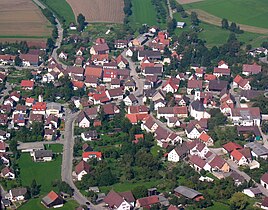
Blochingen is a suburb of the city of Mengen with 902 inhabitants (as of December 20, 2010) in the Baden-Württemberg district of Sigmaringen in Germany .
geography
location
Blochingen is located on the left bank of the Danube not far from the confluence of the Ablach and Danube rivers at the foot of the Swabian Alb , around two kilometers north of the city center of Mengen, at an altitude between 550 and 633 m above sea level. NN .
The Blochinger Mühlbach , which comes from Heudorf, flows through the village . Beavers have resettled in the renatured Danube floodplains in recent years . The municipal area covers around 755 hectares (status: 23 December 2010).
history
The ending " -ingen " gives Blochingen an Alemannic origin. However, grave finds in the place such as the finger-tongue sword and urn grave gifts indicate that the Celts were already settled at the end of the Bronze Age (1200 to 800 BC) .
Blochingen was first mentioned in a document in 1231. Until 1282 Blochingen was under the Count of Veringen-Nellenburg . In a copy of the purchase letter from May 19, 1282 in the copy books of the Landgraviate of Nellenburg from 1758, the sale of the County of Diengau ( Diengoweu ) and Ergau ( Erregou ) with Blochingen by Count Mangold von Nellenburg to King Rudolf von Habsburg is certified. From then on, Blochingen was part of Scheer's rule and was owned by the Habsburgs. In 1314 Habsburg pledged the rule to Count Wilhelm von Montfort (the rich). With the unification of the County of Friedberg with the rule of Scheer in 1369, Blochingen was part of the County of Friedberg-Scheer .
Blochingen came in 1447 under Duke Albrecht of Austria as pledge to Hans vom Stein von Ronsberg. On April 20, 1452, Duke Sigmund of Austria gave it back to Truchsess Eberhard von Waldburg as pledge, three days later with a document dated April 23, 1452 as his own. In 1456 the lien holder, knight Berthold vom Stein, vacated the county.
With the expiry of the Waldburg-Scheer line with the death of Leopold Augustus on October 1, 1764, the County of Friedberg-Scheer came about in the so-called Scheerer Recess of October 23, 1764 to the contract on the sale of the county to the princes of Thurn and Taxis from 22 October 1785. In 1806 sovereign rights over the county of Friedberg-Scheer and thus Blochingen fell to the Kingdom of Württemberg with the Pressburg Peace Treaty . Thurn und Taxis remained the rulership; a pratrimonial office and a rent office remained in Scheer. From the regional reform of 1813, Blochingen belongs to the Württemberg Oberamt Saulgau .
On May 18, 1816, due to heavy rainfall, the Blochinger Mühlbach swelled so much that it tore away the town hall, the school building and four private houses and four people died. The event that became known as the “Bloching Flood” was thematized in the Bloching fool's figure of the water men and Bloigeweible.
Blochingen was part of the Saulgau district after the Oberamt Saulgau was renamed in 1934. From 1938 Blochingen was an independent municipality in the newly formed Saulgau district . In the course of the Baden-Württemberg district reform in 1973 , it was dissolved on January 1, 1973 and Blochingen was added to the former Prussian district of Sigmaringen . On January 1, 1975 the incorporation took place according to quantitative.
politics
coat of arms
The coat of arms of the formerly independent municipality of Blochingen shows in silver over a lowered blue wavy bar a blue cloth scissors opened upwards.
Culture and sights
Buildings
- The Catholic parish church of St. Pelagius was rebuilt in 1820, the rectory in 1772. In the interior of the church there are sculptures from the 15th century and a late Baroque figure of St. Joseph by Franz Joseph Christian (1739–1798).
- There is also the St. Verena Chapel , on the height towards Beuren , and the Schächer Chapel , towards Scheer.
annotation
- ↑ District area 7,548,672 m²
Individual evidence
- ↑ a b Information from Sabine Reger, Head of the City of Mengen, from January 13, 2011.
- ↑ The panorama path around Scheer . P. 49f. In: Wanderbar ... the most beautiful routes. Experience the Sigmaringen district . Sigmaringen district office, Schönebeck printing company, Meßkirch 2004.
- ↑ Blochingen Fool's Association
- ^ Federal Statistical Office (ed.): Historical municipality directory for the Federal Republic of Germany. Name, border and key number changes in municipalities, counties and administrative districts from May 27, 1970 to December 31, 1982 . W. Kohlhammer, Stuttgart / Mainz 1983, ISBN 3-17-003263-1 , p. 549 .
Web links
- District information on the website of the city of Mengen
- Official website of the Blochingen suburb

